
Become a supporter
There’s a handy map key (or legend) that shows you what the road and symbol colours mean. Click the link at the corner of the screen, by the credits.
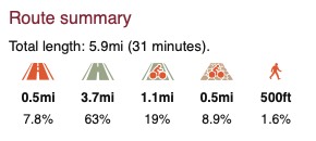
When you’ve planned a route, it’s highlighted in blue and green on the map. Blue for paved sections; green for unpaved.
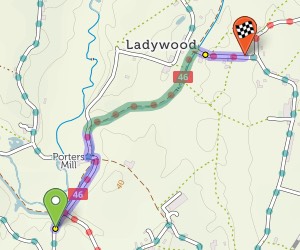
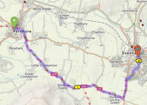
You’ll see summary statistics on the left. These show how much there is of each road type:
From left to right: busy road, other road, paved cycleway/trail, unpaved trail, pushing section.
The ‘layer’ icon on the map allows you to switch to the OpenStreetMap map style, which is less clear but shows more features.
Find out more about how to use our map and cycle route planner.
It’s this easy:
If the route doesn’t go the way you want, you can simply drag it. A new numbered ‘via point’ will appear.
You can also extend the route by clicking points on the map. On desktop: Tick the option on the left that says ‘Click map to add more points’, then click at the new end of your route. On mobile: Quickly double-tap (iPhone) or long-press (Android) the new end of your route.
You can remove a via point by clicking on it and selecting ‘Remove via’ in the popup.
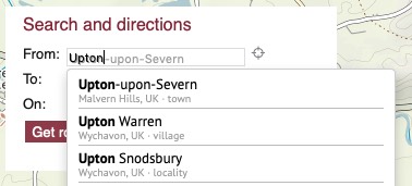
You can type street or town names for the start/end of your route. A pop-up menu will appear as you type – choose the matching place. Click ‘Get route’ when you’ve chosen the start and end.
Our map data doesn’t have house numbers recorded, so just type the street name and town, not the number.
You can add a via point at a named place, too. Click ‘Add at…’ and type the name.
We aim to choose a balanced route that prefers smooth surfaces, but sometimes go off-road to avoid hills, busy roads or long detours. If you’re on a road bike, you might prefer to stay on tarmac at all times. Flick the switch from ‘Paths & roads’ to ‘Paved only’ to change this.
Journeys don’t have to be A–B: you can plan circular round-trips too. Choose your start and end points as per usual, then click ‘Round-trip’. We’ll try to find you a different journey for the way back. (Note that sometimes it won’t be different, particularly on short journeys or in areas with few roads.)
If you just want a ride but you don’t mind where, we can do that too. Click just one start place on the map, or type it next to ‘From:’, then click ‘Suggest a ride’. Up to three circular routes will show on the map:
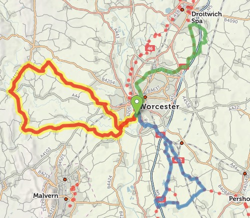
Choose the one you want by clicking on it. You can drag the slider to change the distance.
All things being equal, we choose paved routes. But if a dedicated cycleway is unpaved, or it’d save a stretch on a busy or hilly road, we’ll sometimes choose an unpaved route instead.
On the basemap, unpaved trails are shown with brown dots or dashes; unpaved roads have dashed edges. When you plan a route, the unpaved sections are highlighted in green, contrasting with the usual blue.
If you want to stick to paved sections only, then change the toggle beneath the from/to places. You can even restrict just the section between two via points to paved-only: click the first via point to bring up a popup, and change ‘Go any way’ to ‘paved’.
I’m working on adding more route guides to cycle.travel – not with the full stage-by-stage breakdown (that requires cycling the route, ideally) but with maps, photo galleries, and accommodation finder.
What signposted routes have you enjoyed and would like to see in a cycle.travel guide? I’m keen to hear suggestions.
You may log into cycle.travel’s app or website using an account you set up on the cycle.travel website, or using a third-party login (including Facebook, Twitter, Google, Apple). This is solely a convenience so you don't have to click an email confirmation link.
Data which we process: When you log in with a third-party service, we may receive your name, email address, and/or user ID from that service. This is only stored on our server to allow you to log in. You may choose to publish journeys or travelogue posts using your name or email, but this is entirely optional. Journeys can be saved as ‘private’ in which case no-one will see your name.
We do not use any other user data from these services. We do not use your account to publish posts, tweets, etc. on that service.
If you have any questions or feedback, please email info@cycle.travel from the email address with which you registered the account.
When you register as a user of cycle.travel, we’re grateful for your trust in us, and we aim to remain worthy of that trust.
We will not share the information you give us (your name, email address and exact location) with anyone. We may use your generalised location to show more relevant content (for example, content relating to your nearest city), and your exact location to improve the site experience (for example, centering the map at the right point).
We do not collect any other personal information. However, you should be aware that by saving routes or other information, you may be volunteering your personal information. When you save a route, we offer an option to make the route private, which will conceal the route title and details. Routes that are not marked as private are publicly viewable.
If you choose to upload your cycle.travel routes to another service, the terms and conditions of that service will apply. Our integrations are ‘upload only’; we do not download your activity or route data from any other service.
cycle.travel is not intended for sole use by children. Please ensure you supervise children when using this app.
When you ride a route with the cycle.travel app, we may collect data about road conditions and rider speed. This data will be stored on our servers anonymously, without any information linking it to your account or any other personally identifying information, and is used to improve our routing calculations. You can disable this by changing the ‘Send route feedback’ setting within the app, or by refusing/disabling permission when asked to permit sensor usage.
If you register an account, you can choose to upload your travel tiles, which record your approximate location while riding to an accuracy of c. 3km. This is disabled by default; you can enable or disable this by changing the ‘Upload travel tiles’ setting within the app.
We use cookies on the cycle.travel website for two purposes:
We do not run content from third-party advertisers and networks. Some images on cycle.travel may be hosted on third-party servers who will receive your IP address when these are viewed.
You may at any time inspect and delete your cookies using your browser settings.
You can delete your account by choosing ‘Delete your account’ on your profile page. All your saved routes and other content will be removed. We do not retain any other data about you.
Right to be forgotten (GDPR): See above for how to delete your account. If you have identified further data that you would like to be erased, please email info@cycle.travel with details of the information concerned. You can find out more about the right to be forgotten at gdpr-info.eu.

cycle.travel’s coverage takes a further leap forward today with mapping and route-planning for Australia and New Zealand.
We’re delighted to bring the world’s best bike route-planning to the Southern Hemisphere. You can now use cycle.travel to plan a quiet, enjoyable route anywhere in Australia and New Zealand.
As in many other countries, we’re using real traffic data to make sure you’re routed along the roads with the fewest motor vehicles. We’ve adapted our routing engine so it’s best suited to the distinctive characteristics of Australian and NZ roads. Our maps highlight the New Zealand Cycle Trail and recreational routes in Australia without being cluttered with unpleasant routes along motorway hard shoulders.
We’ve also got all the familiar features you’d expect from cycle.travel – circular routes, ride suggestions, hotels and campsites, paved-only mode, and much more. Head over to the map and give the new area a try.


Made in the Cotswolds. Published by Éditions Système D Ltd.
Log in with your cycle.travel account:
| Password |
Or simply use your account on:
