
Become a supporter
The iOS version runs on any iPhone or iPad running iOS 15 or later.
The Android version will work on an phone running Android 8.1 or later.
You can download maps and your planned routes to use offline.
Use the offline maps option to download the maps for the area you want to ride.
Once you’ve planned your route (or loaded an existing route), turn wifi and mobile/cell reception off.
Use the “Dim between turns” option (in App Settings) – this turns the screen off between turns, lighting up again when it’s time to turn off.
First of all, you’re helping to keep the map and routing servers running, and enabling me to continue working on the website and app – for which thank you! You’ll also get these benefits on the app:
You’ll also get the supporters’ features on the website too, including the extra maps and downloadable PDFs.
* Not yet available on Android.
cycle.travel’s mobile app – available for iPhone and Android – is the companion to this website. Use it to navigate along the route you’ve planned, or simply as a quick and easy route-finder when you’re out on your bike.
They’re designed to complement each other!
Use the website when you’re planning a ride, researching a holiday or browsing through cycle routes.
Use the app for directions when you’re on your bike, or for quick-and-easy routing across town.
Across the bottom of the app screen, you’ll see a set of buttons. Click the Settings icon at the right. You’ll see Help in the menu that appears. This is your quick-start guide to the essential features.
This manual, here on the cycle.travel website, goes into more detail. Click the section headings near the top of the page to browse the pages.
The bottom panel can be dragged up and down. Drag it up to see buttons and the elevation graph. Drag it down to leave more space for the map.
The speedometer doubles as your pause/stop button! Tap it to pause a ride. Your ride will resume when you restart. Tap it again to stop, and clear the route.
The arrow button on the map gets you back to your current location if you’ve panned away.
Yes! Unlike most apps, turn-by-turn directions, offline maps, and international coverage are all free with cycle.travel. You don’t need to pay to “go premium” or “unlock regions”.
cycle.travel is created by one cycling developer (that’s me, aka Richard), and the mapping and routing servers do cost quite a lot to run. So if you enjoy the rides that cycle.travel plans for you, I’d love it if you were to become a supporter for a few pounds/euros/dollars a month. This helps me keep the servers running, and means I can spend more time building new features for the app and website.
To say thanks, supporters get extra features including:
* This isn’t yet available in the Android version.
When you’re planning a route, cycle.travel has always offered the option to export a print-ready PDF in one of several scales. PDF maps are great as a fallback for electronic navigation, or even as the sole means of navigation if you don’t have a phone or GPS device to hand.
Our PDF maps are a little bit special in that they’re “vector maps”. They’re not just on-screen maps pasted into a PDF, but rather, maps generated specially in PDF format. This means they look smoother and can be printed out at any scale without blurring.
Is there a downside? Well, sort of. We’re really proud of the PDF maps, but they’re hard work for our server to generate. Generating each map ties up the server for several seconds, during which it has reduced capacity to plan routes or simply serve the cycle.travel website. At busy times this can cause problems.
To help manage this, from mid-November, our PDF map export will be available for cycle.travel supporters only. This will mean we can keep providing the facility without it becoming prohibitively expensive to do so.
There are no other existing features that I’m planning to put behind this ‘paywall’. PDF cuesheets will still be available free to everyone, and so will pre-generated PDF maps for each route guide. It’s simply that generating the PDF maps takes up a disproportionate amount of server resources.
You can be a cycle.travel supporter for just £2 per month, compared to £5.99 upwards for other routing sites. cycle.travel offers lots of features for free that require premium membership elsewhere, such as multi-day routes, direct Garmin Connect transfer, private routes, (almost) unlimited waypoints – and several features of our upcoming iPhone app. Thank you to everyone who continues to support the site!
cycle.travel’s iPhone app is now ready for beta testing!
The app provides cycle.travel’s routing, turn-by-turn instructions, and offline maps. There’ll be more features in future versions of the app, but right now, you can enjoy a bike ride with cycle.travel on your handlebars. Here are a few of the questions you might have about the beta release.
It works in mainland Europe and Britain, North America, Australia and New Zealand.
Yes, it does. You can log in with your Apple ID too. If your cycle.travel account has the same email as your Apple ID, you’ll see all your c.t routes there.
Apple uses the TestFlight app on your phone to distribute the app. This will tell you if there’s a new version available. I’m continually working on fixing issues with the app, so you should see new versions pop up there that fix issues identified so far!
cycle.travel supporters get these extra features in the app:
Some of the third-party maps, in particular Ordnance Survey and IGN, are in a different projection to the one used by most online maps. That means we can’t show them as part of the main map display, which only supports the standard projection. The map library view allows us to show these maps though without all the features of the main map.
The cycle.travel app usually starts from your current location.
If you want to start from a different place, pan to it on the map, then long-press on the map and choose ‘Set as start point’.
Alternatively, type the name into the place entry (top left), tap it (but not the >), and choose ‘Start from here’.
An Android app is planned for 2023. Although the app code is completely different on iOS and Android, some of the background work (in particular, the maps) can be common to both, so it should take less long than the iOS app.
I might look at producing a bare-bones Android app before then, so if you have any ideas about the absolute basic functionality you’d need, let me know!
You can use the ‘Send feedback’ link in the app. Alternatively, leave a comment on this post, or post on the cycle.travel forum. Thanks!
Ordnance Survey maps are justly famed for their clear, detailed coverage of the British countryside. Generations of cyclists have planned their adventures with an OS map or two stuffed in their panniers or mounted on their handlebars.
You can now use the OS Landranger (1:25k) and Explorer (1:50k) maps right here on cycle.travel. The same great cycle.travel routing… but with an Ordnance Survey map background. It’s perfect for planning off-road adventures or finding the quietest rural lanes.
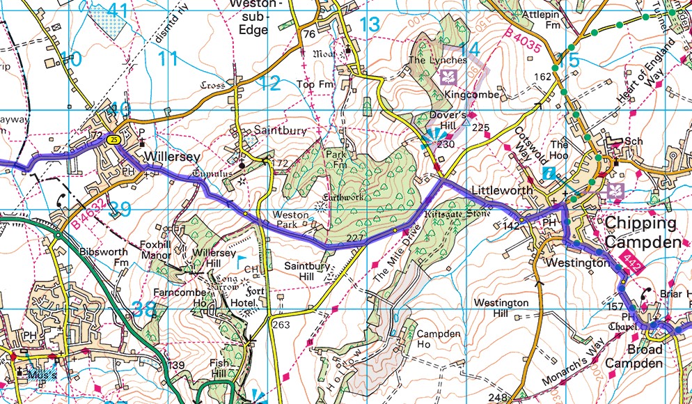
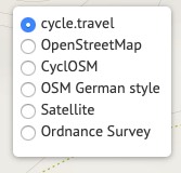
Because OS charge for access to their maps, we can’t offer this free to all-comers – so it’s a cycle.travel supporter benefit. Sign up as a supporter (for just £2 a month) and you’ll get access to the OS maps. Just choose them in the map switcher in the top right-hand corner:
Happy planning!


Made in the Cotswolds. Published by Éditions Système D Ltd.
Log in with your cycle.travel account:
| Password |
Or simply use your account on:
