
Become a supporter
1.7 miles, 10-15 minutes. Easy, cycle tracks, mostly quiet and flat roads, but Barton Lane can have some traffic and has a moderate climb.
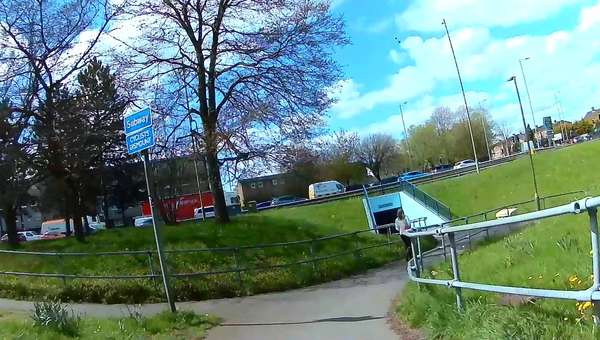
Notes: Thornhill is the Park & Ride to East of Oxford.
* Start in front of P&R on cycle path and head west towards city.
* This merges on to a quiet 'service road' (London Road).
* At the ring road, after a sharp left bend, go into a subway under the ring road. There is ramp down, a half-barrier with a gap of 1.16m and an incline up the other side. If you are unable to dismount, then I think you will be ok, but be ready for the short climb. The subway has a 'Cyclists Dismount' sign, but if you are unable to dismount, and you are ready for the ramp down and up, you should be ok. If you experience problems here, please let us know and we will see what can be done. (See also comments by Sharon Curtis).
* Emerging from the subway, turn right. Then take surface crossings over A420 London Road so you are heading north to the left of the ring road on North Way service road.
* Follow this until you bend left on Barton Lane, which later becomes St Andrews Rd. This climbs at up to 3.5%.
* Go past the Old High Street turn. Turn left on Osler Rd.
* Don't take the Ivy Lane turn into the campus, unless you wish to explore your way through a maze.
* Instead continue to a main entrance, with a big 'The John Radcliffe Hospital' sign, 20 Zone and cycle track and helipad visible just inside. Head on to the cycle track and follow it in to the hospital campus.
* A JR site map showing cycle parking is available in JPG or PDF here (although parking by the heart centre is not currently in use). Cyclists are asked to dismount in some places, which may be difficult for disabled cyclists.
3.4 miles (15-25 minutes). Intermediate: Mostly cycle lanes and quiet roads, but Warneford Lane is difficult until July 2022, and there is a hill to climb (albeit on a now quiet road).
Notes: Redbridge is the Park & Ride to South of Oxford. This route goes via Donnington Bridge and Cowley Road, on mostly traffic-free routes, taking advantage of traffic filters old and new (May 2022).
* Start in front of P&R bus stops and cycle along shared pavement North towards city.
* Cross at traffic lights (press button for crossing signal) and go up shared path on other side 'the wrong way' to Canning Crescent.
* Then cross road, turning right to join the Donnington Bridge protected cycle path.
* There's an inevitable climb, we chose Morrell Avenue as the climb is less steep than Divinity Road, and it is now protected by a cycle lane.
* Warneford Lane is now greatly improved with protected cycle lanes on both sides.
* We choose Sandfield Road rather than Headley Way for the final approach to minimise junctions and crossings.
* The JR Hospital is BIG, the site is over 700m across. This route enters at the South, which is ideal for the Women's Centre and (round to the left) the Main Entrance and Emergency Dept. A bike is a great way to get around the hospital area, but be careful of people walking, wheeling and in vehicles, and slow down or wheel your bike where appropriate.
* A JR site map showing cycle parking is available in JPG or PDF here (although parking by the heart centre is not currently in use). Cyclists are asked to dismount in some places, which may be difficult for disabled cyclists.
2.8 miles, 15-20 minutes. Intermediate: Mostly cycle lanes and quiet roads, but Warneford Lane is difficult until July 2022 and there is a hill to climb (albeit on a now quiet road).
Notes: Redbridge is the Park & Ride to South of Oxford. This route goes via Donnington Bridge and Cowley Road, on mostly traffic-free routes, taking advantage of traffic filters old and new (May 2022).
* Start in front of P&R bus stops and cycle along shared pavement North towards city.
* Cross at traffic lights (press button for crossing signal) and go up shared path on other side 'the wrong way' to Canning Crescent.
* Then cross road, turning right to join the Donnington Bridge protected cycle path
* After crossing the river, turn left into Meadow Lane.
* Continue to the end, turn right onto Jackdaw Lane, and cross onto Bullingdon Road., then East Avenue, Morrell Avenue)
* At Cowley Road, turn right, then left onto East Avenue bending left after 400m.
* At the top, turn right into the Morrell Avenue cycle lane ad climb to the roundabout, using the left hand cycle lane to join the Warneford Lane protected cycle lane. Warneford Lane now benefits from protected cycle lanes on both sides.
* At the traffic lights, position to turn right, into Roosevelt Drive, and follow to the hospital entrance.
2 miles, 10-15 minutes. Easy: Cycle tracks and quiet roads, mostly flat - St Ebbes Street at the end is a small climb.
Notes: Redbridge is the Park & Ride to South of Oxford.
You can ride straight up the Abingdon Road, but this route takes the quieter, but twistier and slower back roads. It's more pleasant, going (legally) through parks, but there are tight turns that requires checking for inclusivity. The route uses the girder-constructed 'pipe bridge' across the River Isis (Thames). People with large cycles may wish to cycle a little further upstream and use the 'gas works' bridge, with its wonderful spiral ramp. Please post a comment on what has worked, or not, for you.
* Start in front of P&R bus stops and cycle along shared pavement North towards city.
* Crossing of Old Abingdon Road (near Go Outdoors) is more complex than it should be, but helped by signals. Just aim for Bertie Place, which is quiet and will lead you into Bertie Park and then Wytham Street. You basically follow NCN5 (white number in red square) from here to the river.
* At the river turn left, and then a sharp left up the ramp of the metal girder 'pipe bridge'. On the other side, descend the ramps, turn left onto Friars Wharf, turn right onto Trinity Street and right again onto Blackfriars Road, to reach a toucan crossing.
* After crossing Thames Street (aka Oxpens) near the ice rink, don't be tempted to ride up Old Greyfriars St unless you want to access the Westgate Centre. Instead, follow the route (and NCN 5) on a separated pavement and continue up St Ebbes St into the centre of Oxford.
There are cycle parking places and cafes at the end of the route.


Made in the Cotswolds. Published by Éditions Système D Ltd.
Log in with your cycle.travel account:
| Password |
Or simply use your account on:
