
Become a supporter
bikepacking.com/routes/attack-of-the-buns/
Attack of the Buns is a 3-day bikepacking route exploring Australia’s Southern Tablelands and Highlands by linking up three significant sections of car-free, wild, forest trails with quiet gravel backroads and short paved sections through four towns. It’s a perfect route for a long weekend that will spoil nature lovers with a buffet of lush landscapes, wildlife, majestic cliffs, and rock formations.
This route was designed with the intention of sharing some of the most beautiful areas in the New South Wales region of Australia within a three or four day trip. It is the perfect balance of smile-inducing landscapes, remote adventure, and accessibility for those of us who aren’t elite athletes. This is one for the nature lovers. Riders will be delighted with the amount of variety this route packs into three days, from the expanses of forest to the the abundance of camping options, the countless little side trips, and especially the hidden treasures including waterfalls, babbling streams, mossy rock formations and awe inspiring cliffs. In addition, there are plenty of opportunities for spotting iconic Australian wildlife, including wombats, kangaroos, wallabies and lyrebirds
Dominated by wide, smooth gravel country roads and car-free fire trails (fire roads for those in the USA), each day the route will take you through an ever-changing buffet of Australian landscapes, including dry eucalypt, sandy coastal woodlands and lush rainforest. You’ll crisscross through national parks several times and have plenty of time away from civilisation without being too far away from supplies.
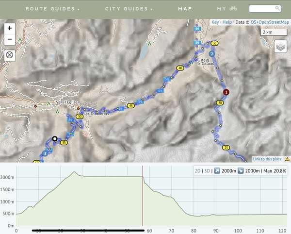
bikepacking.com/routes/zillertal-trail/
Featuring three breathtaking passes, the Zillertal Trail connects the Italian and Austrian sides of the Zillertal Alps in a challenging and rewarding loop. Riders will pedal a diverse mix of trails, enjoy Austrian and Italian cuisine, experience the rugged natural environment, and see two distinct sides of the range, each with its unique history and people...
The Zillertal Trail is a 177-kilometer bikepacking loop through the Italian and Austrian Alps. This route guides those brave enough to ride over three spectacular passes in the Central Eastern Alps. It’s a loop that starts and finishes in Brunico, right by the train station to allow for an easy connection. You’ll find that it stitches a lot of popular and lesser-known cycling sections together into a single route that can usually be completed in three to five days. The natural environment along this track is alpine at higher elevations, with colorful flowers, glacial lakes, and perhaps even snow-capped peaks. The valleys are lush and green, with good infrastructure available to offer accommodation or a taste of local cuisine.
The Zillertal Trail provides a looped adventure over passes that can only be crossed by bicycle or on foot, just north of the well-known Dolomites of Italy. It contains traces of old border posts with Austria, impeccable vistas from each pass, and resource-rich valleys to help you on your way before every climb. The region it crosses in Italy is called Südtirol, an area that was once part of the Austro-Hungarian Empire but was annexed to Italy in 1919 at the end of World War I. This fusion of cultures provides an interesting historic background, as well as a mixture of food that’s very nicely catered to bikepackers’ wishes: rich Austrian bakery treats but also pizza, pasta, and gelato.
Hi Richard, I think the routing is 99% perfect so that just leaves 1% to kvetch about 😄
I found that I was routed on this short, very steep stretch instead of either of the longer, shallower alternatives (which I don’t think are “busy roads”). Even with MTB gearing and no luggage, I had to push.
Is this down to map resolution limitations or is it a conscious choice to prefer a shorter segment? I humbly propose that this steepness of road should be avoided — even for a 500 meter segment. 😁
Hi, on this route which includes “direct” routing between two points (cable car), the elevation profile has a very long perfectly flat section — improbable in the Alps 😉 . The length of the flat section is much longer than the length of the “direct” segment.
https://cycle.travel/map/journey/495502
The iOS app displays the elevation profile correctly (I think)
Sorry if this is already documented somewhere…
This station does not show up when searching in app. How should it be tagged to show up in search?


Made in the Cotswolds. Published by Éditions Système D Ltd.
Log in with your cycle.travel account:
| Password |
Or simply use your account on:
