
Become a supporter

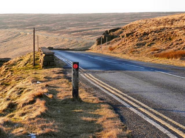
This is Britain’s quietest A road: the A844 on the Isle of Bute, with under 100 cars a day and barely an HGV to speak of.
It’s a bit different to the Victoria Embankment, the A3211, carrying thousands of cars and trucks every hour.
Most cycle route-planners can’t tell the difference: all they know is that it’s an A-road. Ever since we launched cycle.travel’s route-planner, we’ve wanted to do something about this. Now we have.
cycle.travel now chooses routes based on how busy a road is – not just what it says on the signs. We’re using real traffic data for every A road in Britain to track the number of cars, HGVs and bikes on each road, and choosing better routes based on that. Roads with the most HGVs get penalised; roads with very little traffic get promoted.
Try the route-planner now at cycle.travel/map.

We’ve launched this for Cycle To Work Day 2014, to help people find better routes in London and other cities. Check out a route from Stratford, East London, to the City. Our route-planner knows that the road through Bow and Whitechapel, despite being a Cycle Superhighway, has heavy traffic with many HGVs – so it chooses a route via a traffic-free towpath instead.
It’s not just useful for commuters: it helps you find a better leisure route, too.
Take a route from Manchester to Huddersfield. Amazingly, there’s one A road across the Pennines, the A640, with precious little traffic. Our route-planner knows this – and will choose it in preference to the busier A roads, or a winding route on rough tracks.
Or how about Oban to Fort William? The A road on the east side of Loch Linnhe is busy and dangerous; that on the west side is quiet and relaxing. So our route-planner recommends it – with a ferry at each end to cross the loch. Of course, it also uses Sustrans’ new traffic-free Caledonia Way where it’s been opened.
This is one of a series of improvements we’ve made to the route-planner this summer. We’ve improved the circular route function, so you can now find leisure rides wherever you might be. We’ve adjusted the elevation sensitivity, so very steep hills get an extra penalty. And we’ve expanded our coverage from Britain to the whole of Western Europe – in beta for now, but due a full launch later this month.
There’s still more to come – we’ll be adding traffic data for selected B roads and minor roads in coming weeks. We hope you find it useful, and look forward to your feedback on the forums. Enjoy!
The day after London Mayor Boris Johnson unveiled ambitious plans for new cross-London cycleways, Secretary of State for Transport, Patrick McLoughlin, has given a speech on “Keeping London Moving” – and it doesn’t mention cycling once. The rundown of “essential transport infrastructure” covers Crossrail, Thameslink, night-time tube services, airports, HS2, and “record investment in our roads”. But in a speech that starts by looking back to the days when it took “an hour and a half to travel just five miles from Paddington station to the Bank”, there’s no mention of the congestion-busting alternative for five-mile journeys. Bikes? What bikes?
Believe it or not, Britain’s long-distance trains are among the best in Europe for bike carriage. A First Great Western train to Cornwall has 6-12 bike spaces. A German ICE express has 0. But things are changing: carfree.fr reports that new French TGVs will offer up to three bike spaces, Austrian Railjets have six, and future ICEs will have eight. A new EU regulation requires that “railways shall enable passengers to bring bicycles on the train”, though with several caveats.

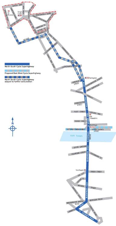
Hot on the heels of plans for a East-West Cycle Superhighway, revealed yesterday, Transport for London has published plans for a North-South Cycle Superhighway from Kings Cross to Elephant & Castle.
But unlike the East-West route, which will be fully segregated all the way from the Westway to Tower Bridge, part of the North-South route will be built as a ‘quietway’ – a back-street route without major new infrastructure.
The route will be segregated south from Farringdon, with a two-way cycle track being built along Farringdon Road, Blackfriars Bridge and Blackfriars Road. North of Farringdon station, the route is envisaged as “a ‘Quietway’ back-street cycle route to King’s Cross”. TfL says the northern section is “subject to further consultation […and…] to further discussion with the Borough of Camden”.
If the consultation shows support for the proposals, the two routes are set to open in March 2016.
As with the east-west route, the main principle is taking away motor traffic lanes to build a two-way cycle track, four metres wide, and separated from the main road by a physical barrier. Turns will be prohibited, minor roads closed, and bus stops relocated to minimise the chances of cyclists coming into contact with drivers.
‘Bus stop bypasses’ will take cyclists past pedestrians waiting for a bus, to a similar design to that used between Bow and Stratford. Traffic lights will be reworked at junctions, with one typical design being “Cyclists run with ahead traffic to maximise green time; turning traffic held back”. Again, unlike the existing Superhighways, the route will not be painted blue.
For the ‘Quietway’ section north of Farringdon, no firm plans have yet been published and TfL says it will launch a separate consultation.
The segregated route proper starts at Farringdon, where TfL is considering either a two-way cycle track, or two one-way tracks (one on each side of the road) “to ensure that the connection between the two sections does not create any barriers or conflict”.
If the latter is chosen (‘Option B’), this might involve lighter ‘semi-segregation’ (such as plastic wands or bollards) rather than a strong barrier; vehicles would be able to cross the track on the eastern side for loading, disabled access, and motorbike parking. ‘Option A’ is a full two-way lane on the west side.
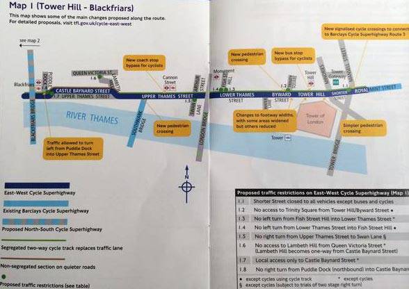
From New Bridge Street and across Blackfriars Bridge, the plan is for a two-way, four-metre track on the western side. Blackfriars Junction, on the north bank, would be the link with the East-West Superhighway, with one slip road being given over entirely to pedestrian and cyclist use. The footway would be narrowed on Blackfriars Bridge “to its historic width of five metres”, with two traffic lanes retained in either direction (one bus, one car).
The two-way track continues onto Blackfriars Road, though with various accesses across it into the One Blackfriars development. One street (Ufford Street) would be closed, and several turns banned, to reduce the number of conflicts. The wide island between cycle track and road would be available “for deliveries and for setting-down bus, coach and taxi passengers”.
There would be no segregated track provided on Lambeth Road, which TfL describes as a “non-segregated section on a quiet borough road”, but it would resume for St George’s Road and the final run to Elephant & Castle.
TfL is honest that “our analysis shows the proposals would mean longer journey times for motorists and bus, coach and taxi passengers along most of the route, both during construction and once complete”. However, they believe that the benefits for cyclists would be worth it, and that the new route would make Blackfriars Road a more pleasant place for pedestrians too.
TfL is inviting comments at consultations.tfl.gov.uk/cycling/northsouth, where the full documents can be viewed. The consultation is open until Sunday 12 October, and there will be public exhibitions in Blackfriars during September.
The London Cycling Campaign has already welcomed the plans. Its chief executive, Ashok Sinha, said:
“Overall, LCC is really pleased to see commitments to substantially reallocate carriageway space to ensure protected space for cycling – particularly on the east-west superhighway, where cyclists regularly make up almost half of traffic during the morning peak. LCC’s main concerns are that some of the planned new junctions are not safe enough and that the width of the new cycle tracks is too narrow in places. We’d encourage all our members and supporters who use the routes to feed back on the proposals on the TfL website.”

London’s cyclists will, at last, get a safe way to cross town from east to west if new plans from Transport for London get the go-ahead.
Plans are being announced tomorrow (Wednesday 3rd) for east-west and north-south Cycle Superhighways, with Dutch-style separation from car traffic. But plans for the east-west route have leaked a day early – and they promise a step-change in Central London cycling.
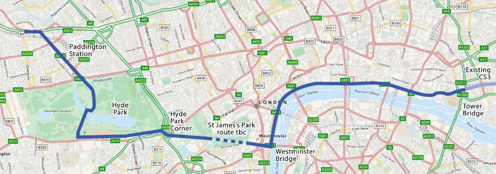
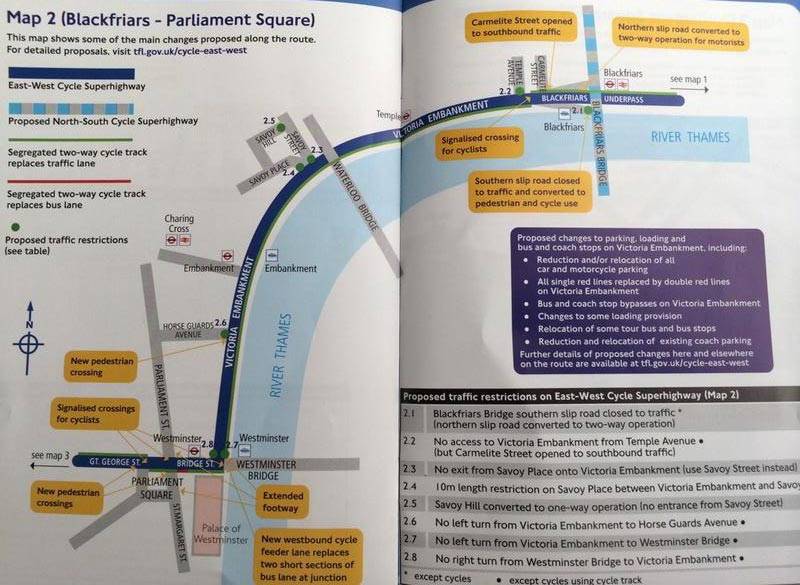
The new route will run from Tower Bridge, along the Embankment, to the Houses of Parliament – where it will turn ‘inland’ to head through Hyde Park to Paddington and the Westway. The route will connect with the existing CS3 at Tower Bridge, and a mooted new cycleway over the Westway. (Base map: OpenStreetMap data, cartography by Mapquest.)
The route will be a “wide kerb-segregated cycle track”, offering protection from motor vehicles. Existing traffic lanes will be removed to make space for the new cycle track.
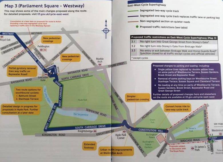
In most cases the track will be two-way, but on Westbourne Terrace, near Paddington, there will be two one-way cycle tracks “replacing a traffic lane in both directions”.
To achieve this, several junctions will be torn up and turns for motorists restricted. Horse Guards Road, between Green Park and Whitehall, and Shorter Street, at Tower Bridge, will be closed to through traffic. A raft of banned turns will be introduced to prevent motorists cutting across the cycle lane. At Blackfriars Bridge, an entire slip road will be closed to traffic, to become the link between the east-west and north-south Superhighways.
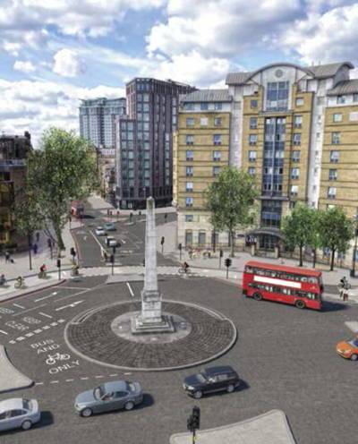
Perhaps the most high-profile changes will be at Parliament Square, where a new cycle track will replace existing car and bus lanes. Traffic signals will guide cyclists past traffic here, with the route swapping to the south side of the road then back to the north. Then on the northbound side of Constitution Hill, opposite Buckingham Palace, the existing horse ride will become a two-way cycle track.
However, the route plans are not yet finalised – particularly through the Royal Parks. TfL has not yet been able to come up with a finalised design for St James’s Park, saying merely “Proposals are subject to discussion with the Royal Parks”. A circuitous route has at least been identified at Hyde Park, passing through the centre of the park using South Carriage Drive and West Carriage Drive, but even then TfL admits “Detailed design is still in progress… further consultation at a later date”.
And in an unusual change for London’s Cycle Superhighways, the mockup images are bereft of light blue paint on the cycle lanes – reflecting the end of Barclays’ sponsorship?
The plans will be officially launched tomorrow, together with designs for a north-south Cycle Superhighway from Kings Cross to Elephant & Castle, via Blackfriars Bridge. TfL is also planning a number of feeder ‘Quietways’ along back streets, to give convenient links from the two Superhighways into the City and West End.
Once the plans are live, you will be able to have your say at TfL’s consultation website, tfl.gov.uk/cycle-east-west.
The plans were posted to Twitter by user @hodadr – many thanks! – who also noted wryly: “of course, when the black cab drivers hear of this there will be uproar”.


Made in the Cotswolds. Published by Éditions Système D Ltd.
Log in with your cycle.travel account:
| Password |
Or simply use your account on:
