Become a supporter

A new cycleway in Bolton will provide a safe, direct route for local cyclists – but don’t expect a scenic view.
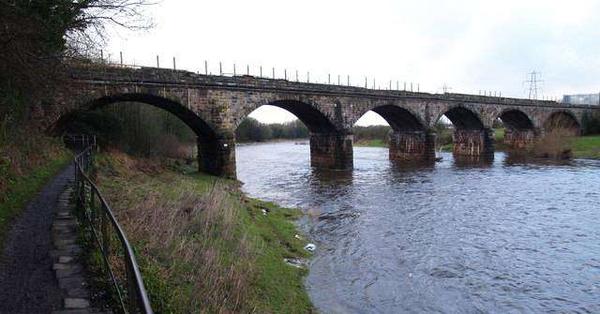
Concerns about local children throwing stones from the Darcy Lever viaduct have led councillors to insist that the cycleway should be “caged” as it passes over the viaduct.
According to the Bolton News, a local resident told the council planning committee:
“My big concern is there will be more vandalism to the properties next to the cycleway. Kids might start throwing stones onto the houses below.”
The route will follow a disused railway between Bolton and Bury. Another councillor asked for a similar cage over a road bridge, saying “I don’t want to see kids throwing rocks on to cars travelling at 50mph”.
The new cycleway has been planned for 17 years but has only now got the go-ahead. This section will run from Darcy Lever towards the town centre, crossing the busy A666 dual carriageway on a bridge. Eventually, the route is planned to run further towards Bury, and to become part of a regional cycle route from Wigan to Rochdale.

With weather forecasters promising a brief Indian summer, perhaps the time has come for this pedal-powered ice cream parlour, spotted in Los Angeles. Peddler’s Creamery, in their words, “produces high quality artisan bicycle-churned organic dairy and non-dairy ice cream and frozen desserts”. And you can even churn your own: the Peddler’s Club invites locals to come along and pedal constantly at a 15mph speed to make ice-cream. “After pedaling 75 miles, you get a pint of ice cream to enjoy; after pedaling 175 miles, you get a flavor named in your honor for a week.” Like an exercise bike… just with ice cream at the end.

A long-disused railway viaduct in Carlisle could finally be opened up for cycling and walking access – thanks to, of all people, the Highways Agency.
The Government body, which runs the motorway and trunk road network, incongruously took over a number of old British Rail structures as part of the current Government’s ‘Bonfire of the Quangos’, which saw the last remnants of British Rail abolished.
Now, they are responding positively to a long-running local campaign to open up the Waverley Viaduct over the River Eden. The bridge, in the west of the city, would link Hadrian’s Cycleway with National Cycle Network route 7, and provide a way for people from north-west Carlisle to easily access the infirmary. Cycle Carlisle describe it as “a safe, green easy route from the north of the city to the south”.
A Highways Agency spokesman told the News & Star:
“We are indeed in ongoing discussions with a group about re-opening the viaduct for pedestrian access. Although we are limited in the kind of practical support we can offer and issues such as the planning permission still need to be resolved, the Highways Agency is very supportive of the [local campaign] group’s aspirations and the idea of them forming a trust to help reopen and manage the bridge.”
The bridge could also become part of the English Coastal Path, mooted as a long-distance walk around England’s coastline – following the successful paths in Wales and the South-West. Likewise, Hadrian’s Cycleway and NCN 7 together form a coastal cycling route around the Solway Firth.
You can find out more about the campaign for the viaduct at www.savethewaverleyviaduct.co.uk.

The final design for a busy Oxford junction has received a thumbs-down from local cyclists.
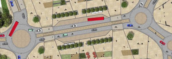
Frideswide Square, outside the railway station, is being rebuilt by Oxfordshire County Council. Early designs were criticised by Oxford cyclists in April. Now the County Council has published a final version of the junction – and it hasn’t won over any more hearts and minds.
The design includes three roundabouts and no dedicated cycle tracks. Instead, the space between the road and the buildings on either side will now be designated as ‘shared use’, to be used by cyclists and pedestrians equally. The plans have been reworked from the earlier design to give a tree-lined barrier between the road and the shared-space area, plus larger bus stops.
Legally, the existing footway will be converted to a cycle track under the Highways Act 1980. The council says:
“Oxfordshire County Council is proposing to install shared use footway and cycleway areas within the north and south sides of the proposed transformation of Frideswide Square, Oxford in front of the rail station. The aim of the proposal is to improve the safety of both pedestrians and cyclists travelling between the rail station and Oxford city centre.”
Speaking to the Oxford Mail, council leader Ian Hudspeth said the aim was “to try and make it as easy as possible for people to cycle there”.
However, Simon Hunt from cycling campaign Cyclox pointed out “Any roundabout is always a concern for cyclists and here we have got three.” Local cyclists have described the plans as “another stitch-up” and “impossibly inconvenient”.
Comments are invited by Friday 12th September via www.oxfordshire.gov.uk/frideswidesquare. Work is due to start immediately afterwards.

If you’re feeling left out by the current craze for electric bikes, a Kickstarter-toting entrepreneur might have the solution: an affordable(-ish) conversion kit. For £350 plus shipping, the curiously-named Barak comprises a motor for the hub, a battery, and a controller. It’s the brainchild of Micah Toll, who has a good pedigree in the e-bike industry, so should prove more than a flash in the pan. (Or, of course, you could just pedal like the rest of us.)
Log in with your cycle.travel account:
| Password |
Or simply use your account on: