
Become a supporter
I'm a bit of a late adopter, just installed the app on my iPhone.
I've selected on of my existing routes and wish to export a .tcx of it, so I can send it to my Wahoo.
I routinely do this by opening the website on my phone, however the app only offers to expert to a GPX track.
Am I trying to do something that the app can't do please? Maybe the answer is to move from exporting as .tcx to .gpx track?
Hi
Just a comment that sub folders for saved routes would be dead handy please. As I create more routes, the current flat structure is a bit inelegant.
Thanks
Graham
Hello Richard
I'm putting together route through Warwickshire and c.t will not route through a particular point. I've had a look in the OSM and am not able to identify anything wrong, perhaps you could have a look please? If you are able to fix it, and it's something I could have done if I'd had the requisite knowledge, some pointers would be appreciated.
I'd like to route from Frankton to Birdingby. I've created a test route and have moved the start and end points to show the section through which routing is not possible. It seems to be where the footpath comes in from the North.
https://cycle.travel/map/journey/215394
Thanks, Graham
Hi. I usually create a ride on my desktop computer and save it. Then open on my iPhone 5s and create a .tcx course file, that I then sync with my Wahoo Elemnt Roam.
Today I couldn't select .tcx course and when I looked closer, see that option is sort of "greyed out" on the phone. The radio dot isn't full circle, see screen shot. This is a "something changed" condition.
I managed in the end by creating the .tcx course file on my desktop and emailing it.
Would you mind having a look at this please? It's not a showstopper however would be more inconvenient without access to a desktop PC as when away from home on tour. And if something is broken, who knows what the next manifestation will be ?-)
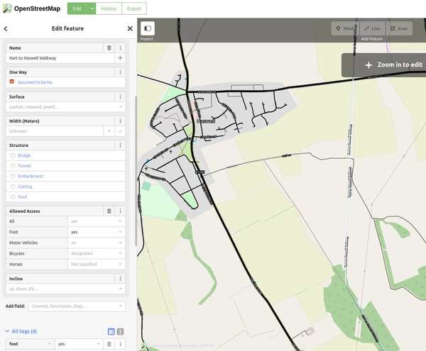
How does c.t decide what counts as paved please?
Context of the question is I rode the Hart to Haswell Walkway as part of a longer loop a couple of days ago however it's this bit that is https://cycle.travel/map/journey/135543 that prompted the question. In the OSM there is no value specified for the surface, see image below.
What is actually on the ground isn't paved. Some of it is loose matchbox sized stone, some is muddy puddles, some is wooden boardwalk. Whilst it was passable on a touring bike with care, I'd have been carrying my road bike. I last rode it in the summer of 2017 on the touring bike and it was just as rough, but drier!
The reality is it was probably compacted when first constructed. I'd probably tag it as unpaved now, as the more precise tags seem to refer to the surface as it is intended to be, and do not take in to account neglect.
I am planning to update the OSM surface tag by the way.


Made in the Cotswolds. Published by Éditions Système D Ltd.
Log in with your cycle.travel account:
| Password |
Or simply use your account on:
