
When planning your route, it’s good to know what the road or track quality will be like. Clicking on any section of your planned route will open up a popup, from where you can choose:
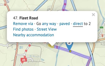
Although cycle.travel tries to find the best cyclable route between any two places, there’ll be times when you want to take a direct route that cycle.travel doesn’t permit – for example, on a path where cycling isn’t officially permitted, or on a road that hasn’t made it into the OpenStreetMap source data yet.
You can still plan a route including such a section. Put a via point on either side of the straight line section. (Don’t worry about the no doubt circuitous route it’ll choose.) Then click the first via point, and in the popup bubble, select ‘Go direct’. The route will change to take a straight line to the next via point.
You can see an elevation profile for any route you plan. Just click the elevation button on the left.
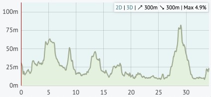
Moving your mouse over the elevation profile will show that place on the map, and vice versa. If you drag the route, you’ll see that the elevation profile is updated as you do. The total climb and descent, and the steepest gradient, are listed in the corner of the profile.
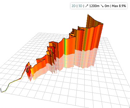
You can even click ‘3D’ to see a 3D elevation profile of the route!
There are two additional buttons on the left: one to reverse your route, one to undo the last change you made.
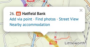
You can delete all the via points before or after a certain point. This is useful if you’re splitting a long route into several sections. Right-click the point (or click while pressing Command on a Mac), then choose ‘Delete before’ or ‘Delete after’.
cycle.travel can generate a colour map PDF of your journey. First save the journey, then click the ‘PDF’ button. You’ll be asked to choose a scale – City scale is the largest scale (most close-up), Local and Touring are in between, and Long-distance is the smallest scale (most zoomed out). The PDF typically takes a few seconds to generate.
For each journey, detailed turn-by-turn instructions appear in the left-hand panel. You can have a compact printed form of these, called a ‘cue sheet’. Save the journey and click ‘PDF’ as above, but then choose ‘Cue-sheet (instructions only)’.
Creating an account on cycle.travel lets you customise your map preferences. Log in, go to ‘My bike’ then ‘Profile’. Here you can choose miles or kilometres, your average speed and number of miles per day, and whether clicking on the map always adds new via points.
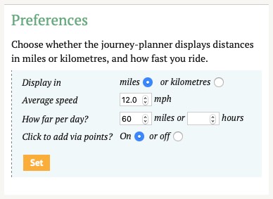
You can also set your home country, which helps cycle.travel guess whether you mean France or Texas when you type ‘Paris’; and your home location, which is used to centre the map when you first view it.


Made in the Cotswolds. Published by Éditions Système D Ltd.
Log in with your cycle.travel account:
| Password |
Or simply use your account on:
