

Ok, this is perhaps the biggest feature suggestion I have! I apologise in advance because I think it'll be difficult to implement, but it's enough of a problem that I think it's worth stating.
Normally, a "road closed" sign is good news for cyclists. It means there'll be little or no motor traffic for a while, and there's almost always a pedestrian access that (at least conventional) cycles can squeeze through. Sometimes, that's not the case, though, and we have to find another route on the fly. Doing this with cycle.travel is hard, because the only control points we have are via-points.
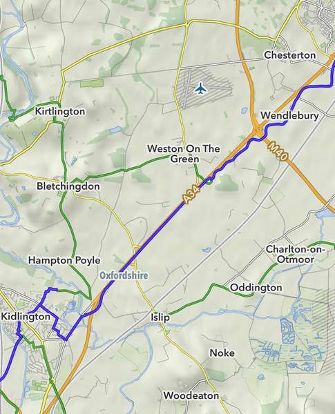
I hit this problem a couple of days ago in Oxfordshire, where an important chunk of NCN51 is (really) closed. The attached screenshot should be clear; I was heading northeast from Kidlington, and at the time couldn't see an alternative other than the truly miserable path beside the A34. (The blue line is my GPS trace.) Now I can see it on a bigger screen, I think I could have taken small roads through Islip, Charlton-on-Otmoor, etc, with the additional benefit of skipping Bicester (which it turns out, is incredibly hostile for cyclists), but I couldn't see that at the time.
The screenshot is from MapOut. They seem to be happy with user screenshots but I have to say “© OpenStreetMap contributors”.
The Sustrans closure sign unhelpfully said words to the effect of "work it out for yourself", but C.T could have done a much better job here. However, with positive via-points alone, I first have to decide for myself what the diversion should be. That's rather fiddly at the side of the road. It'd be really very useful if I could put a negative via-point in to say "actually, don't go this way". My understanding of the routing algorithm suggests that it would be difficult to implement, but I seem to hit something of this nature once or twice on most multi-day trips.
Thanks!


Comments
If your feature request is for a 'negative' - don't go this way - viapoint I can't offer any opinion except to point out that such a feature needs to clear if it is to be applied to 'this' or 'any future' route preparation. The fantastic 'Markers' feature is a great way to remind ourselves.
In relation to your specific issue there are a few options using the website on your phone. (I am not familiar enough with the app to comment).
Firstly, on a blank map enter your location, your destination (either actual or where you know the diversion ends) and let CT plan your route. Most times it's going to generate the route that you can't follow. Now click on 'Find Alternative' and CT should find at least one alternative way. Sometimes, varying the start point (perhaps back a km) will give more options.
We can also choose different options (Paved, Gravel, Any) to offer more choice.
Secondly, we can take a DIY approach. Taking CT's suggested (unpassable) route, add a viapoint on the section that you cannot travel on and manually move this in different directions. We can see CT 'lock on' to an alternative route. 'Dropping' the viapoint lets us assess the route and if unhappy, move the VP again.
That's 3 distinct options for your scenario (excluding the main road)
We could also just use out start point and use 'Suggest a ride' to see if CT suggests a different way of getting to where we want to go. Pot luck!
It's worth remembering that changing the underlying map can highlight bike routes, too.
All in all, CT is pretty well equipped for dealing with the scenario presented.
Now, 'stress' planning on the side of the road may not be a lot of fun and is even more difficult in bright sunshine or especially rain but it does require internet access. For offline route planning OSMand is a very useful app and has the 'negative viapoint' option. Not the easiest app to master, though.
This is a tricky one. As you say, the routing algorithm doesn’t really lend itself to negative waypoints.
I do wonder whether something could be built along the lines of the ‘Alternative route’ feature, which under the hood is not entirely different from what you’re suggesting – it keeps looking for a route until it finds one that is more than n% different. So in this case, it would keep looking for a route until it finds one that doesn’t go through that point. Might work… but wouldn’t be easy.
I’ll give it some thought but, until then, I find that dragging the route and watching how it changes often reveals interesting alternatives – you’ll often find that c.t settles down to a particular alternative as you drag.
Coincidentally I was in Bicester the other day looking at cycling facilities. It’s better than it was now that Sheep Street allows cyclists (except on Fridays), but it’s still pretty hostile – the number of side-road crossings between Wendlebury and the town centre is just silly.
Thanks both!
On “find alternatives”: this is a good suggestion, thanks! It doesn’t show I’m the UI if I have any via points already set so it means making a new, temporary route to my next stop, but that’s often Ok. Actually since I tend to plan on a big screen first and almost always set a via point somewhere along the route, I’d assumed that the mobile rendering just couldn’t fit it into the UI. I was wrong about that, so perhaps it’s something to try next time.
I do use markers for local roads that I know to be closed, or for poor choices before CT picks up my OSM updates, and that works Ok for advance planning.
I think in different conditions I might have been able to come up with a nicer route by looking at the wider map, but it was hot and bright and I was tired and sweaty :-)
I’d not visited Bicester before. It looks like I didn’t visit Sheep Street but I spent a lot of time waiting for crossings over huge roads. There’s a lovely cafe in Launton though!
I’d also not long come off the path beside the A40, which is surprisingly good, so hoped that the A34 version would be similar. OSM does reflect the surface difference, but that’s too much detail for side-of-the-road planning.