
Become a supporter
Ok, this is perhaps the biggest feature suggestion I have! I apologise in advance because I think it'll be difficult to implement, but it's enough of a problem that I think it's worth stating.
Normally, a "road closed" sign is good news for cyclists. It means there'll be little or no motor traffic for a while, and there's almost always a pedestrian access that (at least conventional) cycles can squeeze through. Sometimes, that's not the case, though, and we have to find another route on the fly. Doing this with cycle.travel is hard, because the only control points we have are via-points.
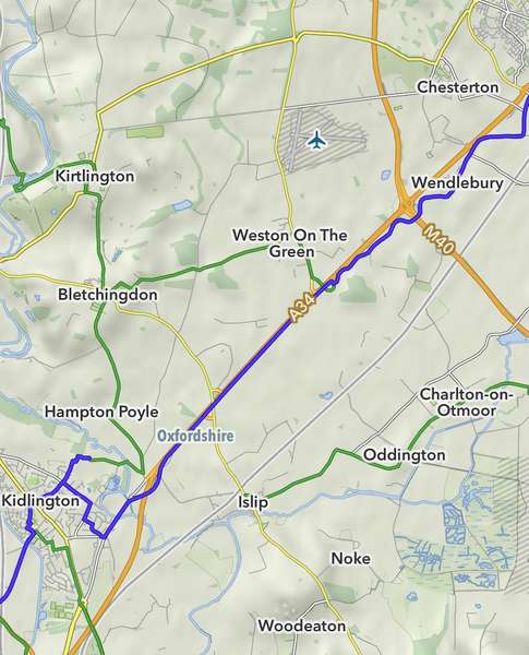
I hit this problem a couple of days ago in Oxfordshire, where an important chunk of NCN51 is (really) closed. The attached screenshot should be clear; I was heading northeast from Kidlington, and at the time couldn't see an alternative other than the truly miserable path beside the A34. (The blue line is my GPS trace.) Now I can see it on a bigger screen, I think I could have taken small roads through Islip, Charlton-on-Otmoor, etc, with the additional benefit of skipping Bicester (which it turns out, is incredibly hostile for cyclists), but I couldn't see that at the time.
The screenshot is from MapOut. They seem to be happy with user screenshots but I have to say “© OpenStreetMap contributors”.
The Sustrans closure sign unhelpfully said words to the effect of "work it out for yourself", but C.T could have done a much better job here. However, with positive via-points alone, I first have to decide for myself what the diversion should be. That's rather fiddly at the side of the road. It'd be really very useful if I could put a negative via-point in to say "actually, don't go this way". My understanding of the routing algorithm suggests that it would be difficult to implement, but I seem to hit something of this nature once or twice on most multi-day trips.
Thanks!
In the iOS app I’ve noticed some glitches with the elevation profiles that I think are caching problems.
I’m not exactly sure how to reproduce it, but I think I’ve seen it when accidentally extending the route to some point along it, producing a roughly mirrored profile, but then it doesn’t get refreshed when I delete the accidental waypoint.
I’ve also seen the profile get out of sync, so one route is displayed with the profile of another, but I’ve been unable to reproduce that.
I’ve attached a screenshot, but I also just noticed that the app didn’t think I was signed in at the time. It could be related, since the routes are private!
Restarting the app seems to force a profile refresh.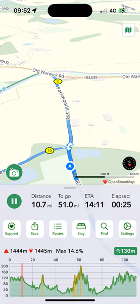
I’ve noticed that the “elapsed” figure is often a vast under-measurement. It always seems to increase monotonically, but slower than real time. I’ve been getting to the end of a day’s ride and seeing elapsed times of 2-3 hours, which makes me look really fast, but is clearly wrong :-)
I’m using iOS’s “low power mode” so I wonder if some event fires less often than normal.
Hi!
I have a couple of simple suggestions for marker rendering.
Thanks!
Example: https://cycle.travel/map/journey/784956
On the web interface, the northern part is coloured green and the southern part is blue. However, the colour changes at the via point, wherever it is, so moving it changes the green/blue split. The whole western (dashed) section should be green/unpaved, I think.
It also changes the paved/unpaved summary on the left.


Made in the Cotswolds. Published by Éditions Système D Ltd.
Log in with your cycle.travel account:
| Password |
Or simply use your account on:
