Become a supporter

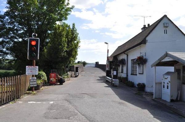
Local cyclists can now cross Hay-on-Wye’s historic toll bridge for free, thanks to a deal negotiated by local bike shop Drover Cycles.
The crossing over the River Wye, a short way north of the town at Whitney-on-Wye, charges a 10p toll to cyclists – a level fixed in an Act of Parliament. But when cyclists cross the bridge in the evening, there’s no toll-keeper on duty to collect tolls, and the “auto-toll” device fails to register their presence.
Maggie Taylor, who bought the bridge with her husband for £400,000 in 2012, explained to the Hereford Times:
“The 10p toll has been a bit of a pain to implement and collect, and it did feel a bit churlish to charge cyclists – but our hands were tied. The toll is set by Government and we couldn’t just waive it.”
Instead, Drover Cycles has agreed to pay an annual licence on behalf of local cyclists – both those from the Velo Hay cycling club, and the shop’s customers. Anna Heywood said:
“We frequently go over the bridge on our Wednesday evening rides. The auto-toll isn’t set up for collecting fees from cyclists and there wasn’t always someone on hand to take our 10 pence pieces. We realised other cyclists weren’t paying either and didn’t want Maggie and Grahame to miss out, so agreed an annual licence with them.
"We decided it’d be a nice bit of extra value to offer to our customers. With the arrangement in place we can promote more local bike rides heading out that way. Besides serving as a convenient river crossing, the bridge is a great place to stop for tea or coffee.”
Even including new constructions such as the Humber and Severn bridges, there are only around 20 toll bridges left in England and Wales. Several, such as the Whitney bridge and Aldwark Bridge in Yorkshire, carry low levels of motor traffic and so form useful parts of cycling routes. Others, however, still carry busy traffic to this day – such as Swinford Bridge in Oxfordshire, where local cyclists are campaigning for a traffic-free roadside path to be built.

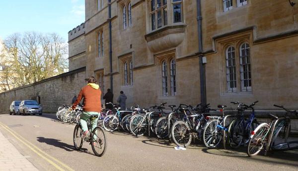
Oxford’s cycle campaign Cyclox, with support from CTC and Sustrans, has launched a ‘Vision for Cycling’ in the university city.
The proposals set out a future where “the wellbeing of the city is supported by clean air and active travel” – and outlines the work needed to get to that aim. The new manifesto was presented to Ian Hudspeth, leader of Oxfordshire County Council, in a photo-call this week.
The Vision states that “Oxford is already one of the best cities for cycling in the UK, but with cycling at about 17% of all trips we are far behind some of our European neighbours”. It believes that this could reach 25% by 2020, including 30% of journeys to work.
To achieve this, it calls for at least £10 to be spent per head on cycling, led by “an inspirational Cycling Champion”. It proposes that Oxford should aim for a “comprehensive unbroken inclusive dual cycling network”.
The dual network, which provides both fast, direct routes (‘cycling freeways’) and less busy ‘quietways’, is a long-standing aspiration for Cyclox:
“The standards to which the two networks are constructed should be no different, but the engineering designs are likely to have to solve different problems. Freeway route design must pay greatest attention to minimising the hazards of close traffic. Quiet routes will have to take especially into account interactions with pedestrians, whether shared-space or segregated.
“This means a continuous, uninterrupted route, provided for cyclists in both directions. A constantly-heard criticism of the present provision is that it is not continuous. Signs that display ‘End of Cycle Lane’ must be consigned to the museum.”
Outside Oxford, the document calls for better routes to nearby towns and villages such as Eynsham, Abingdon and Woodstock.
The full document can be viewed online here.

The Government has announced a £2m windfall for councils around Britain to encourage cycling, walking and public transport.
Among the winning schemes are a Tyne & Wear plan to encourage kids to cycle to school, and cycling promotion in Stratford-on-Avon (Stratford Greenway, pictured). Transport Minister Baroness Kramer said:
“These successful schemes have changed how people travel, with communities now making healthier and greener choices. Dozens of great projects have been delivered already under this fund and I’m glad we’ve been able to support more today.”
The schemes receiving funding are:
Local contributions will bring the total to around £3.6m.

An ambitious plan to transform a Liverpool flyover into a ‘bike route in the sky’ has sailed past its first hurdle.
The Churchill Way Flyover is proposed for demolition by Liverpool City Council, at a cost of up to £4m. But the Friends of the Flyover think it would be better reinvented as a public space, cycle route and walkway, with markets, allotments, and exercise areas along its length.
The first challenge for the Friends was to raise £40,000 for studies into the project – which they succeeded in doing on Monday night. 361 people chipped in to help pay for the work. The money will be used to undertake detailed surveys, work out business plans, and consult with the council, Liverpool John Moores University, and National Museums Liverpool.
Kate Stewart, from Friends of the Flyover, told the Liverpool Echo:
“It has really been quite overwhelming to see how much the city is taking it to heart. Lots of businesses have been supportive and it feels more like a partnership across the city. The public have been incredible.”
The project is deliberately modelled on New York’s High Line, where a mile-long disused railway viaduct became a public open space. If it comes to fruition, there will be cafés, independent shops, and market stalls along the length of the flyover.
For cyclists, a new route would be opened up between the city centre and Lime Street station, currently an unpleasant experience on a bike. The flyover would be lit at night thanks to wind and solar energy generation.
Find out more at the Friends of the Flyover website.

The European Parliament has voted to reduce the blind spot on lorries – but action could still be four years away.
MEPs voted this morning to adopt new standards first put forward last year. Following lobbying from cycling organisations across Europe, the new legislation says that lorries must be built with larger windows and rounded fronts:
“The new cab profile will also contribute to improving road safety by reducing the blind spot in the driver’s vision, including under the windscreen and to the side of the vehicle, which should help save the lives of many vulnerable road users such as pedestrians or cyclists. The new cab profile should therefore, after an appropriate transitional period, become mandatory.”
According to the European Cyclists’ Federation, HGVs are implicated in almost one-fifth of fatal accidents on Europe’s roads. CTC, the British cycling charity, says that lorries comprise only 5% of traffic yet are involved in 18% of cycling fatalities:
“The outdated brick-shaped design of lorry cabs creates ‘blind spots’ around the cab making drivers unable to see cyclists and pedestrians close by. This is particularly dangerous when drivers make manoeuvres, especially left-turns, which can result in the lorry cutting across the path of a cyclist (during the period 2000-2010, 55% of cyclists deaths occurred when lorries made a left-turn).”
But the new legislation won’t come into force immediately. First it has to be approved by the European Council, which comprises the heads of each country in the EU. Concerns have already been expressed that the British government may seek to overturn or water down the proposals.
The Greek government, which currently holds the presidency of the EU, is aiming to secure member states’ agreement in June. If the adoption of this text takes place in 2014/2015, says the EU, the new trucks could be expected to be seen on the roads by 2018-2020.
The London Cycling Campaign has been at the forefront of calls for safer lorries. It points out that lorries are involved in half the cyclist fatalities in Greater London, even though they make up only a small fraction of motor traffic. It wants London councils to install safety equipment on their lorries and those of contractors even in advance of the 2018 date; 11 councils have already signed its pledge.
Log in with your cycle.travel account:
| Password |
Or simply use your account on: