
Become a supporter

Since launching cycle.travel in 2013, we’re delighted to have become the route-planner of choice for thousands of bike tourers, recreational riders and city commuters.
But our number one requested feature has always been from road bikers – who love cycle.travel’s routing on quiet lanes and cycleways, but want a guarantee that they’ll never be sent off-road onto gravel or earth.
That day is now here. You can now choose “paved only” when planning your route, and cycle.travel will stick to asphalt roads, cycleways and bikeable paths. Just click the new toggle switch:
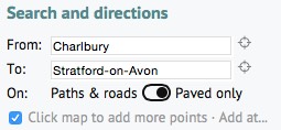
All our route-planner features are still usable in paved mode – route suggestions, round-trips, draggable via points – and it’s as fast as ever. Better still, you can switch between route types during a journey: just set a via point, then click that point and choose ‘paved’ or ‘any way’.
Head over to our map and route-planner to get started.
Our route-planner and maps are always free to use. Several users have asked for a way to support the site.
If you’d like to show your support, you can now make a donation via Patreon, the number one site for supporting online creators. All supporters will get a regular monthly newsletter with the latest news, tips and reflections from cycle.travel.

You can now use cycle.travel to plan a route anywhere in Europe – from the Adriatic to the Baltic and beyond.
We’ve expanded our map and route-planner to include Eastern Europe and Scandinavia. It’s all with the same lightning-fast route-planner that hates busy roads and loves quiet lanes and cycleways. You can plan a round-trip from Athens to Norway’s North Cape in seconds – a full 6,819 miles there and back. Try it!
We’re always fine-tuning our calculations to ensure the best routing. The latest changes, now rolled out across the whole of Europe and North America, include special logic to avoid really steep hills; smarter routing away from busy multi-lane roads in cities; and clearer turn instructions in rural areas. We also tweak our routing in specific regions to take account of local cycling characteristics: recent changes here include better handling of London’s new Quietway routes, and a more sceptical approach to several US states where designated cycle routes follow busy, dangerous routes. Meanwhile, we’ve also updated our cartography to have clearer, more attractive hillshading.
Countless bike tourists are now using cycle.travel to plan cycling expeditions across Europe and North America. The feedback from cyclists who’ve had happy holidays following a cycle.travel route is the best part of running the site (check out this 33-page thread on the Cycling UK forum) – thank you all so much for your support. Our traffic for 2018 is up almost 100% on 2017 and we have big plans for 2019, so stay tuned!
Our newly added countries are:
No, we’re not suggesting the use of performance-enhancing substances (apart from cake), but when you absolutely have to take that shortcut…

When you’re planning a route with cycle.travel, sometimes you just want to take the direct route between two points. Maybe there’s a path that (horror of horrors!) is missing from OpenStreetMap, our map data source; maybe cycle.travel is trying fervently to keep you off a busy road, and you’d rather grit your teeth and ride on; or maybe you just want to make like Lance and engage in a bit of accidental cyclocross.
It’s pretty easy. Just plot your via points as normal, then click the one where you want to go off piste, and choose ‘Go direct’:

And voila, routing en direct. As they say on all the best descents in France.
Other new features on our route-planner include PDF ‘cue sheets’ for turn-by-turn directions; coverage of Slovakia and Hungary; improved GPX and TCX export for your GPS unit or phone apps; and dozens of little tweaks to make the routing even better. Head over to the route-planner and try them out for yourself.

Scotland’s canals are run by a Government body with the does-what-it-says-on-the-tin name of Scottish Canals. All four of them are open for cycling.
Fort William to Inverness. This waterway along the Great Glen joins several lochs, including Loch Ness, with several canal sections. The canal was built with a towpath but the lochs obviously weren’t! For cyclists, the best route is along NCN 78 (the Caledonian Way), which links the gravelly canal towpath with forestry tracks, a converted railway path, and minor roads. It’s not ideal for fast road bikes but fine on anything that can handle a bit of gravel.
Lochgilphead to Crinan. Famously pretty yacht canal that shortens the route to the Hebrides. Fully suitable for cyclists, and part of the long-distance Caledonian Way.
Glasgow–Falkirk and Falkirk–Edinburgh. A continuous towpath cycling route between Scotland’s two greatest cities. In Glasgow, there’s a spur from the main route at Maryhill towards the city centre. Otherwise, you can continue to Port Dundas along the canal, and from there to Dumbarton on a tarmac cycleway. The surface is generally good, often light gravel though occasionally a little muddy: the Union Canal is the more erratic of the two. Signposted throughout as NCN route 754.

West Stockwith, near Gainsborough, to Worksop and Chesterfield. Unimproved grassy footpath from the Trent to Worksop, except within Retford. Resurfaced as NCN 6 for a couple of miles west of Worksop, and then muddy but rideable on a suitable bike up to the old tunnel at Kiveton. On the other side of the collapsed tunnel, parts of the towpath have been upgraded in conjunction with nearby railway paths to form NCN 67, part of the Trans-Pennine Trail.
Long Eaton to Langley Mill, near Nottingham. Suburban canal in D.H. Lawrence contry. Good all-weather surface from Long Eaton to the edge of Ilkeston as part of NCN 67, which then heads west via the long-lost Nutbrook Canal. The Erewash continues from Ilkeston to Langley Mill with an unpaved but firm enough surface, popular with local cyclists.
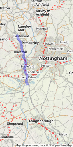 Erewash Canal
11mi
Open in route-planner »
Erewash Canal
11mi
Open in route-planner »
Watford Gap to Leicester. Very rural towpath, not suitable for cycling apart from the branch into Market Harborough, and within Leicester city centre.
Nottingham to Grantham. Derelict canal slowly being restored to navigation. Good quality compacted surface from the edge of Nottingham – though the line in Nottingham city centre is lost – past Cotgrave to Harby. It then becomes a grassy footpath until near Bottesford, where the surface improves as part of NCN 15 into Grantham.
Rambling network of rivers and lakes (‘broads’). Generally no cyclable towpaths but there are plenty of enjoyable country lanes in the area. (Run by the Broads Authority.)
Cambridge towards Ely. Very popular for cycling within Cambridge (downstream from Jesus Green) and out to Waterbeach. Not rideable north of there. The connection from Waterbeach to NCN 11 at Lode, and from there to Ely, is sadly still missing. (Run by the Conservators of the River Cam and Environment Agency.)
King’s Lynn to Ely and Bedford. No consistent cyclable path though sometimes minor roads run along its banks. Short cycleways for a short way south of King’s Lynn, again south of Ely, and in Bedford town centre. Good NCN routes on quiet roads and railway paths in the area. (Run by the Environment Agency.)
Northampton to Peterborough and Wisbech. No cyclable path except within Peterborough and Northampton. (Run by the Environment Agency.)
Leicester to Nottingham. Now resurfaced and improved from Leicester as far north as Syston/Cossington. Also cyclable on the canal section within Loughborough. Otherwise a rural river with no opportunity for cycling.
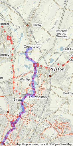 Leicester to Cossington
7mi
Open in route-planner »
Leicester to Cossington
7mi
Open in route-planner »
Nottingham to Gainsborough and the Humber. Rideable from Trent Lock and Long Eaton to Nottingham along the ‘Big Track’ cycle path. Otherwise, generally no cyclable path but some minor roads run directly along the riverbanks in its lower, tidal reach.
Market Deeping to Spalding and the Wash. No consistent towpath, but nearby field paths and minor roads along the banks are often cyclable, several as part of NCN 12. Could form part of a very enjoyable ride for those with sturdy bikes! (Run by the Environment Agency.)
Lincoln to Boston. NCN 1 runs alongside on a converted railway trackbed, the ‘Water Rail Way’, and on quiet lanes. The Fossdyke Navigation, a Roman canal, continues west from Lincoln and is cyclable as far as Saxilby.
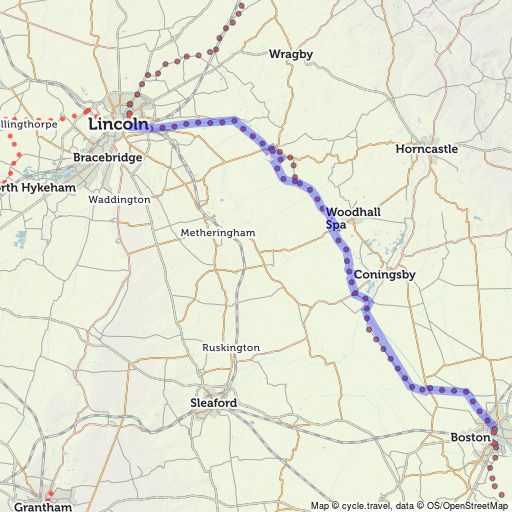 Water Rail Way
33mi
Open in route-planner »
Water Rail Way
33mi
Open in route-planner »


Made in the Cotswolds. Published by Éditions Système D Ltd.
Log in with your cycle.travel account:
| Password |
Or simply use your account on:
