
Become a supporter

Today cycle.travel’s route-planner gets the biggest single improvement since it launched – a new feature we call Smart Turns.
cycle.travel now casts a forensic eye over every turn and junction on your route. Turns across busy roads get downrated; so does weaving from street to street in cities; so does any turn where you have to dismount. Routes with fewer turns are preferred, and safe crossings (e.g. ‘toucan’ crossings) get a bonus too.
The result is safer and simpler routes in both town and country. But, more than that, the turn-by-turn directions for each route are also clearer and more reliable.
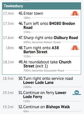
New instructions like ‘Cross major road’ and ‘Leave town’ help you navigate each step at a time. Two-stage turns, where the road flares past a central island, are shown as one clear instruction. So too are doglegs, where a left is followed immediately by a right. Plus there are new symbols to highlight unusual sections of route: unpaved trails, busy roads, ferries, and sections where you need to push.
We’ve also made it easier to follow long-distance cycle routes, such as EuroVelo or the National Cycle Network, without repeatedly dodging off-route and back on again.
As well as this major new feature, we’ve made dozens of smaller improvements to cycle.travel’s route-finding. It’s now smarter about routing on unpaved tracks, particularly in mainland Europe. Roads with (legally) cyclable hard shoulders get a better rating. Cycle contraflows and other one-way systems are handled better.
We’ve made a concerted effort to improve OpenStreetMap’s minor road data in the rural US, so you can find a safe, enjoyable route without having to ride down an Interstate or other busy road.
Finally, we’ve added Croatia and Mexico to the route-planner. Mexico doesn’t yet have height data but we’re working on it!
These improvements are partly laying the groundwork for two exciting new additions to cycle.travel this summer – watch this space.
As always, the foundation of cycle.travel’s route-planning is the wonderful OSRM project, and the data contributed to OpenStreetMap: big thanks to all the OSRM developers and OSM contributors for their hard work.

The Rhone Cycle Route, a 1,100km tour beside the river through Switzerland and France, has been anointed as the newest member of the EuroVelo route network.
The designation as EuroVelo route 17 is intended to give the Alps-to-Mediterranean route the same popularity as the successful EuroVelo cycleways along the Rhine, Loire and Danube rivers.
The Rhone route passes through Geneva, Lyon and Avignon before splitting into two final legs to the Med – one to Montpellier, one to Marseille. The Swiss section has a rapid descent from the headwaters to Lake Geneva, while the French section is mostly flat. Over 50% of the French route is on traffic-free ‘greenways’.
The EuroVelo designation is awarded by the European Cyclists’ Federation, the umbrella group for cycling organisations, and partly funded by the European Union. You can find out more about EuroVelo 17 on their website.

Traffic signals in Austin, Texas, are to respond to approaching cyclists by staying green for longer.
An innovation being piloted by the city will encourage cyclists to use a dedicated smartphone app which reports their position to city networks. If the rider is approaching a traffic signal that’s about to turn red, the lights will stay green for a few seconds longer to let them across safely.
Technology has long been used to give ambulances and other emergency vehicles free passage across cities, but these are generally sensor-based rather than GPS. Austin’s initiative is also believed to be the first time that such technology has been used to encourage motorists out of their cars.
Teri Pennington, city CIO, explained the concept to Government Technology magazine:
“Our system pulls that GPS data, and if the light is close to turning red, it may hold a few more seconds. The app's GPS then tells the system it is past the light, and the system starts to watch the next light in your path.”
The app will use a speed filter to determine whether you’re travelling by bike, car or on foot. The system will also be used to smooth traffic flows after major events, such as football games, and to speed buses through the city.
Researcher Alexandros Nikitas, from the University of Huddersfield, makes a convincing case for the growth of urban bike hire schemes across the world – saying “they are seen to complement the city’s public transport services, and give the city a more human-friendly feel”. His research also suggests that such schemes are effective in promoting cycling to motorists.
Cycling forums are forever full of “what bike should I choose for my epic trip?” questions. It’s a fair bet that no-one has ever answered “a New York hire Citibike”. But that’s what Jeffrey Tanenhaus chose for his trans-American. Yes, he could have got a better bike for the $1,200 fine levied for late return. That’s kinda not the point…


Made in the Cotswolds. Published by Éditions Système D Ltd.
Log in with your cycle.travel account:
| Password |
Or simply use your account on:
