
Hi Richard,
On the following example, it seems like the elevation graph is stucked...
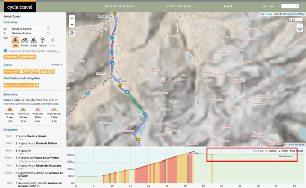
https://cycle.travel/map/journey/653430
All the best
Olivier

Become a supporter
cycle.travel now has Ordnance Survey maps
Plan multi-day adventures easily
Thanks to Swaledale Outdoor Club!
We’re now in Australia and New Zealand too
Stick to tarmac with our new routing option
cycle.travel expands to Scandinavia and Eastern Europe
Smart Turns – new on cycle.travel's route-planner
Hi Richard,
On the following example, it seems like the elevation graph is stucked...
https://cycle.travel/map/journey/653430
All the best
Olivier


Made in the Cotswolds. Published by Éditions Système D Ltd.
Log in with your cycle.travel account:
| Password |
Or simply use your account on:
Comments
Olivier, I'd be pretty sure that's because of using the 'direct to' feature.
If you split the route into 2, one part before what I presume is a train? and one part after you'll be able to see the elevation profile for both 'halves'. If both 'halves' are in the same folder you can see the 'whole' journey - especially if you recreate the stretch between viapoints 1&2.
Hi Hobbes, thank you for the trick - it works perfectly. Actually that bug is not a big deal for me, I just wanted to mention it so that Richard can keep busy when he's bored ;-)
Ah… I think I’ve figured out why that is. It basically seems to happen when you use the ‘direct to’ feature, and the via points on either side have an elevation difference of more than 300m. I will see if I can fix it – thanks for spotting.
I’ve worked out a fix for this but it’ll need the server to go down for five minutes or so, so it’ll go live in the next day or two. Thanks again!
Excellent, thank you !
After it had been working for a while, I get the feeling that the problem has come back...
https://cycle.travel/map/journey/982482
Grettings