

I was recently in Devon and wanted to test my Wahoo GPS with a cue sheet generated by cycle.travel so I planned a little loop round lanes that I know near Crediton. I was riding east from Shobrooke towards Thorverton and spotted something odd which would have confused me greatly if I didn't already know the roads there...
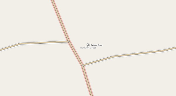
The road I was on comes to a T-junction at Raddon Cross with the road coming down from Raddon Hill. I needed to take a right and very shortly after that a left. The cue sheet just instructed me to take a left, as if my road had priority at the junction and I was bearing right. If I had obeyed the left turn instruction I would have in fact headed north up the hill.
I thought that the problem was probably caused by somebody making a mistake on OSM but that looks ok (Raddon Hill road straight through, others stop at it)?
If there is something wrong on OSM could somebody please explain it so I learn how to fix that kind of thing in the future - thanks.
I worked out how to correct a couple of mistakes I found in OSM-Todmorden and cycle.travel picked up my changes a week or so later.


Comments
I’m pretty sure that’s c.t doing something wrong rather than OSM! I’ll look into why – thanks for spotting it.
Cheers.
I have noticed the same thing happen a couple of times back up in the Calder Valley since then. Again, if I had been actually navigating from the cue sheet I would have got confused by missing instructions.
It happened again today. It may or may not be relevant (?) but all of the times that I can remember it happening were when 2 consecutive cue points would have only been (say) 5-20 metres apart.
Oh, and I had set announcing turns 30 metres early.
Yes, I think it’s something to do with the detection of dog-leg junctions going awry. Looking into it.
Hi Richard.
I recently plotted another route via that junction and that time it was handled correctly... Did you do something to fix the problem or is it something more random which might sometimes not fail?
I did something to fix the problem!
Thanks!