

Hi,
I'm planning a route along the Eurovelo 10 and came across come confusing behaviour on CT. It seems that in some places the path of EV10 depends on the zoom level. Not sure if this is a bug or a feature in the underlying data or in CT.
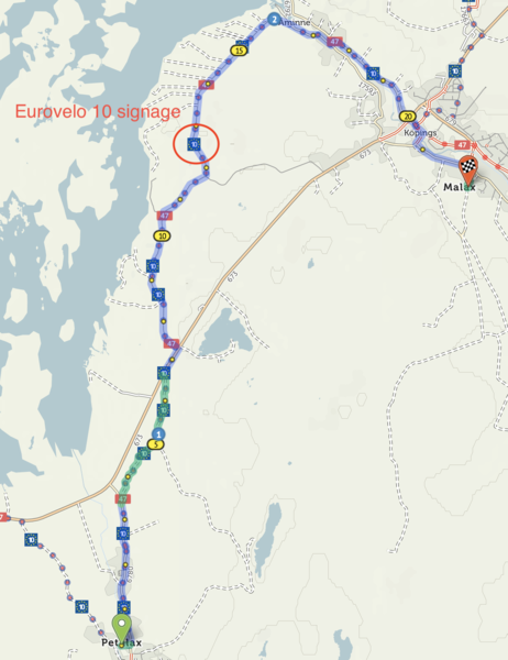
Take a look at this simple route https://cycle.travel/map/journey/388062
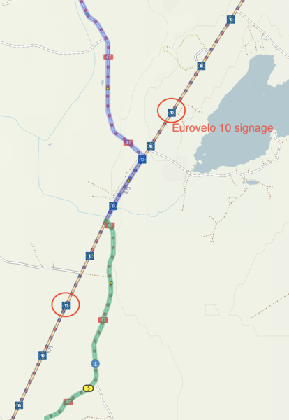
When you are zoomed out a bit, the route I've drawn follows the EV10 displayed on CT base map. But when you zoom in the route of EV10 changes on the base map and it no longer follows the smaller road, rather the signage is now on the big road.
Any ideas whats going on here?
I've also added two screenshots, just in case this is something others can not reproduce.
Br,
Sand


Comments
It’s showing as following the major road at all zoom levels to me.
I think what’s probably happened is that it was previously following the smaller road, and your browser has cached some of the old map tiles – it’s a bit of an occupational hazard with web maps. You can force it to refresh at a given zoom level by clicking ‘Link to this place’ in the bottom right, which will anchor the page at this particular location, then doing a force-refresh in your browser once or twice (often something like ctrl/shift+F5, or alt/shift+command+R).
cycle.travel uses OpenStreetMap as its source data, and OSM is currently showing the route as following the major road. Seems a slightly odd decision given that there’s a minor road alternative but EuroVelo route choices can be strange!
Force-refresh indeed fixed the issue and EV10 is now displayed consistently on all zoom levels. Thanks for the tip!
If I remember correctly, someone was asking in the forums an easier way to import Eurovelo routes to CT. I've found that the official GPX files they provide can be quite inaccurate (and also too long for CT to process) - making them somewhat useless. Thus, I'm now drawing the route by hand.
But. As CT uses OpenStreetMap as its source, would a routing feature like "From Helsinki to Copenhage using EuroVelo 10" be feasible? Would save the user from importing and/or drawing route data that essentially already exists in the underlying data.
As I don't understand all the technicalities involved, this might be a silly suggestion.
Generally what I’d suggest is to use the cycle route map:
https://cycle.travel/browse
(also at the top of the ‘Route guides’ menu)
From there you can choose from a couple of hundred routes, open them and customise them as you like. Lots of the EuroVelo routes are already on there but I haven’t yet added every route. I’ll have a look at adding Helsinki–Copenhagen etc. – let me know if there’s any others you’d like.
Oh, right. That looks just what I'm looking for! Just missing the one I need, the part of ev10 that follows the south and west coast of Finland https://www.openstreetmap.org/relation/2265095#map=6/62.365/26.477Essentially a mix of the Gulf of Bothnia and Gulf of Finland parts.