

Hello,
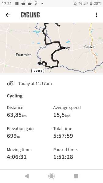
I've noticed high discepencies between the elevation gain shown on cycle.travel and the one recorded by my wahoo roam. for example in this trip https://cycle.travel/map/journey/217164 CT gives me 410m gain. while my wahoo gave me 699m gain. and I'm inclined to believe to later judging by the states of my legs :)
I've been traveling a lot around Belgium using cycle.travel but have only noticed this issue recently. the difference is sometimes up to a factor of 2.
I understand this might be due to the resolution of the elevation data but it makes planing a bit more hazardous. Has anyone else noticed this ? Or could there be an issue with the belgian elevation data specifically?
anyway thanks for the amazing website.


Comments
Hmmm. Do you have a link for this route on cycle.travel?
It's in the post but I'll put it back here again. https://cycle.travel/map/journey/217164 and I'll check that it's public
thanks!
Whoops, sorry - missed that! I’ll take a look.
I’ve had a bit of a fiddle with this and the good news (!) is that I’ve uncovered an issue with elevation on railway paths. I’ve fixed this now and done a little extra tweaking.
cycle.travel now shows 540m elevation for this route. This looks broadly right to me. I’m having difficulty seeing where the Wahoo gets its 699m from – it’s possible cycle.travel is still slightly understating the gain but not by 160m, I think. Even RideWithGPS (which tends to overstate total climb) is only showing 584m.
Thanks a lot, I don't mind a little under estimate. I'll report back here next time I ride on a railway path.
my first guess was that it was simply a side effect of a difference in resolution of the elevation data on the map and the sampling from the Wahoo. Maybe lots of little half meter ups & downs recorded yet not present on the resolution of a country-wide survey. something similar to the Coastline Paradox : https://en.wikipedia.org/wiki/Coastline_paradox
Thanks again and have a nice day
I experience the same, but I think GPS will tend to record more elevation gain - if there is 3m error in the position, due to the nature of some tracks, the evelvation may be 10 m wrong.
My GPS often records 50% more elevation than expected