

Hi there. Came across a strange quirk with TCX course export. I'm syncing to a Wahoo Elemnt ROAM, and when exporting with elevation data from the website (have clicked the elevation profile button before exporting), when it comes through to the device, the total climb is about 15x the actual elevation.
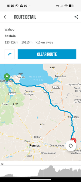
As an example, here's a route I rode at the weekend: cycle.travel/map/journey/876470 . Total climb in cycle.travel is 680m. On the Wahoo (both in the app, and on the device), it reckons at 10215m! Screenshot from the Wahoo app is below.
When riding, the device then obviously thinks that I'm doing a superhuman effort as it reckons all climbs are 15x higher/steeper than they are...
As an aside, exporting as a GPX route does seem to work successfully.
Wondering if you've seen this before, or have any insight? As there's a workaround of using a GPX route, not a huge deal, but it would be good to be able to use TCX courses too.
Thanks!


Comments
Guy, this happened to me 2 or 3 years ago in Spain and it would have been TCX routes too.
Richard advised me here that it was a Wahoo issue and it eventually sorted itself out.
I could see the relevant climbing info in CT so I wasn't too bothered by the multiples that Wahoo was telling me.
I don't believe the device recording was incorrect, though, so your hopes of superhuman climbing stats may be misplaced :-)
Thanks for the response Hobbes - appreciate it and glad to know I'm not alone!
However, I've been looking into it and actually managed to work out why this happened.
In the original route linked above, when downloading as TCX course, in the file there are a number of trackpoints with a not-a-number tag in the trackpoint: <AltitudeMeters>NaN</AltitudeMeters>
Using a simple script to go through and replace just these tags with the valid, integer AltitudeMeters tag from the previous trackpoint, writing out the new TCX, and then uploading it to the Wahoo app, we have something much better. Wahoo app shows 709m total elevation.
So my feature request for @richard, I guess, would be ensure that TCX course export does not contain any trackpoints with <AltitudeMeters>NaN</AltitudeMeters>.
(note that I also tried just removing these NaN altitude tags, instead of replacing them with the 'previous known good' altitude. This gave me a route with 1,611m elevation, so better than before, but not great: filling in data from the previous known good track point was a lot more accurate).
That’s odd! When I download it as a TCX course I don’t get NaN values at all. If you can reproduce it consistently then I’d love to know the steps to do so.
Hi Richard,
Definitely consistent on my end. I _am_ checking the 'Announce turns 30m in advance' box. If I un-check this box, no more NaNs.
Checked box, I get NaNs (on Windows, using either latest Chrome or latest Firefox, same result).
Hope this is enough to go on - if you can't reproduce do let me know and I can send a file and/or screencap.
Ah, that’s perfect – thank you. Yes, it’s the ‘announce turns’ that was doing it. I’ve just tweaked it and it looks good from here; let me know if that fixes it for you!
Ah, brilliant - that's sorted it! Wahoo app now showing 711m elevation which I'd say is well within tolerance for that route. Excellent, and thanks Richard for the quick fix! Appreciated!