
There are several areas I've noticed that my and my friends local knowledge know is a perfectly good rideable track, is there a way I can overide the automatic routeing to follow these tracks?
Cheers
Richard North Yorks

Become a supporter
cycle.travel now has Ordnance Survey maps
Plan multi-day adventures easily
Thanks to Swaledale Outdoor Club!
We’re now in Australia and New Zealand too
Stick to tarmac with our new routing option
cycle.travel expands to Scandinavia and Eastern Europe
Smart Turns – new on cycle.travel's route-planner
There are several areas I've noticed that my and my friends local knowledge know is a perfectly good rideable track, is there a way I can overide the automatic routeing to follow these tracks?
Cheers
Richard North Yorks


Made in the Cotswolds. Published by Éditions Système D Ltd.
Log in with your cycle.travel account:
| Password |
Or simply use your account on:
Comments
An example would be helpful. Create the route, make sure it's not tagged as private, copy the url and post it here.
Have you tried adding via points along the track you want to follow?
First thing to check is if you have the "paved only" toggle on or off.
If that's not the problem you could have a look that the OSM data is tagged properly.
Bear in mind that the track may be perfectly rideable but it may not be legal to do so and that will be reflected in the underlying data.
On the assumption that it is legal you could use the method outlined in this thread https://cycle.travel/forum/thread/4868 to plot a direct (straight line) route to where you want to go. Bear in mind, though, that for the straight line the PDF or export to a gps unit will not reflect the actual route. Things like distance and elevation will be off.
Depending on where in the world you are, I've learned that when CT does not direct me along the most obvious route there is normally a good reason for it! :-)
An example will make everything clearer
Yes - if you have an example then I’d be keen to see it to figure whether cycle.travel is making the right decision!
There’s no way to “personalise” routing decisions so that it always takes your favourite tracks, I’m afraid, but I’m always keen to improve the routes it chooses for everyone – whether that’s by improving the base map data or making cycle.travel’s choices smarter.
I've experienced the same thing here:
https://cycle.travel/map/journey/401474
https://connect.garmin.com/modern/course/147521970
they're the same route.Garmin shows the correct route.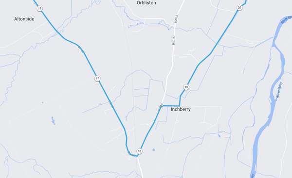
I think that’s because you’ve got via point 4 just south of the junction – probably by just half a metre or so! – so c.t is steering its route that way. If you move it a bit further up the B9103 it’ll go the way you expect.
Sorry for my slow response to your replies, HobbesOnTour, Richard Fairhurst and Jon Hunter, I've had a very busy few days. I will attempt to find an example in the next few days but I think HOT's comment about it not being a legal route is probably the main reason, I use Starva Heatmap for checking out route but I have noticed some of their heat tracks do go over sections that are not an official bridleway or road at times.
I was just curious and I feel happy now with the replies.
I do love Cycle Travel, on a visit to New Zealand this year it was brilliant for ride planning and exploring, also for walks we did in remote areas.
Last year in france having the IGN maps on my phone was amazing.
Thank you Richard and all who have helped making this awesome tool available