

The bridleway and footpath that link the Strawberry Line to Mendip Way and Yatton shops, and are marked as such on the ground do not appear to be in the planner. See the dogleg forced into my route: 'Stoke Bishop, BS9 to Sandon circular via Common Lane & Dolemoor Lane'


Comments
Is this what you wanted to do please?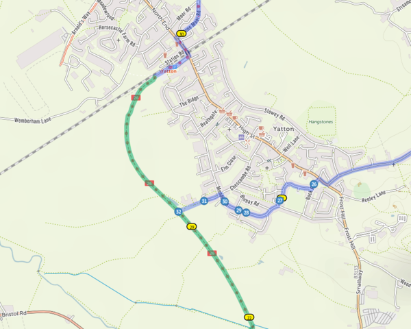
Yes, that looks like the bridleway. I usually use the footpath slightly to the south because the bridleway has deep puddles that never dry out. I suppose accommodating a preference for a footpath into a cycle planner is a bit difficult.
If I’m reading you right, the issue is with this and adjoining paths – https://www.openstreetmap.org/way/39178808?
These are currently marked in OpenStreetMap (which cycle.travel uses as its source data) as simply “tracks” with no indication of bike access. In the UK, cycle.travel won’t route over a track unless it’s marked as open to bikes. So (assuming this is the case) changing the details in OSM to say that bikes are allowed (bicycle=yes) will allow cycle.travel to route over it next time there’s a map update.
Worth noting too that cycle.travel won’t route over stiles (for obvious reasons!) – I think there might be one of those marked on the footpath.
Yes, Biddle Street is the bridleway (according to the 1:25000 map a special access lane) and Gang Wall the footpath, but I think that what is actually marked on the ground to reach Chescombe Road is the track slightly north of the footpath, seen on cycle streets. This is the route picked by Cycle Streets if you ask it for a short route from Chescombe Rd to the S-Line just S of the footpath, whereas given the same task cycle.travel goes round by Yatton station. (Quite why cycle streets scores Chescombe Road as having very busy sections is beyond me.)
Both have Sustrans signs as access routes from the Strawb Line to the centre of Yatton and are both rideable, although, as remarked, the puddles on the bridle path are so deep, wide and perpetual that I always go along the Gang Lane footpath. There are no stiles on the Gang Lane footpath between the village and the S-line, and I do not recall gates, although they may be pinned open.
Checked using test route that cycle.travel ignores these accesses, unlike Cycle Streets: https://cycle.travel/map/journey/175496
Also registered for Open Street Map and edited the two continuations of Chescombe Road and the short track SSW from it to have tag bicycle=yes, which seems to have taken effect in Open Street Map.
And it has finally sunk in what the difference, as you explained, between Cycle Streets and cycle.travel is. Cycle Streets will accept the tag all, with the unfortunate effect that you get routed down steps.
The OSM mods have now taken effect, including the links to Yatton village and Carditch Drove to Honey Hall