
Become a supporter

Cycling in London is the best way to arrive at work every day with a smile on your face. Whatever the slings and arrows of outrageous road design may throw at you, it’s (almost) always worth it.
But we can’t deny that the road design is, indeed, often outrageous. London’s main roads are not a flower-strewn paradise of cycling happiness and we wouldn’t pretend they were. Rather, they’re the busiest, most frenzied, and densest in Britain.
At every traffic light, an aggressive tide of cars, buses and lorries waits impatiently to push through. So although this page may appear stern, it’s because we want you to emerge safe from your encounters with London traffic.
As a general rule, most London cycling accidents happen at junctions: roundabouts where traffic is accelerating fast to get a space, complex networks of turnings such as the Kings Cross area, or simple left-turns where cars cut you up. You can’t avoid the last-named, but where possible, consider planning your journey to avoid the busiest major road junctions. Unfortunately, a Cycle Superhighway is no guarantee that the junctions will be safe.
Some roundabouts have pavement routes, but these are invariably slower, forcing you to balance speed against safety. When you do cross a busy roundabout, being assertive and ‘taking the lane’ will get you across more safely than skulking in the gutter and running the risk of being swiped by a left-turning vehicle (much though we hate to say it). Transport planners are experimenting with Dutch-style roundabouts, with a separate outer cycle path, which could offer salvation for these dangerous ‘gyratories’.
London traffic lights invariably have tight timing to usher the maximum number of cars through on each green. In other cities, skipping a red light might earn you an angry gesture or an annoyed beep. In London, it can be genuinely dangerous, particularly on the larger junctions where it takes several seconds to cycle across.
Many junctions have ‘advanced stop lines’ (ASLs), painted spaces for bikes at the front of a traffic light queue. By all means use these if they make your passage easier, but don’t expect much from them: cars frequently trespass on them, and the cycle lanes leading up to them can be dangerous gutters that put you at risk from queuing vehicles. Their main advantage is that they bunch cyclists together, keeping us out of lorries’ blind spots and making us more visible to drivers.
Mouthy cabbies are a London caricature, and the private-hire stealth vehicles of Addison Lee are the guys we love to hate.
All frivolity aside, though, the biggest danger on London’s roads are construction lorries – responsible for 40% of cycling fatalities. We would counsel patience and a very wide berth when you encounter these grumbling, stinking behemoths of the city streets. Please don’t be tempted to squeeze down their side, and don’t put yourself in a position where the driver’s inattention could kill you. Though a few boroughs are now insisting that their contractors fit cycle-safety technology and train their drivers, this is, as yet, a small minority.
London has the best bus service in Britain, and cyclists have full claim to the many bus lanes. Sharing space with a 15-tonne double-decker isn't always a relaxing experience, to say nothing of the taxis; but it helps whisk you through the traffic, and bus drivers are (by and large) skilful and professionally trained.
All the way from its source in the Cotswolds, the River Thames is a barrier to cycling. London is no different. Inevitably, every river crossing is crammed with traffic: Southwark Bridge is perhaps the best of a bad lot. Be especially careful at the junctions on either side where the bridge traffic gathers and disperses.
Dreams of a cycle-only bridge haven’t come to fruition, with Boris choosing to build a cable car instead. Still, there are alternatives in the east: the free Woolwich ferry and the Greenwich Foot Tunnel.

London's hire-bike network, aka Barclays Cycle Hire, is streets ahead of anything else in the UK. Cramming on a tube can become a thing of the past; once you've registered, these robust, if slightly clunky, bikes are free to use for half an hour within central London.
You'll never be first off at the lights, but you'll get there faster, and cheaper, than your subterranean counterparts. For outer-suburbanites, in particular, it takes away the hassle of forcing your bike onto an over-crammed commuter train: park your own bike at the station, pick up a Boris bike in town.
Bikes are hired from docking stations scattered around central London.
To rent a bike, you first need to buy ‘bike access’ for a day (£2), month (£10) or year (£90). You can do this at the docking station with a credit/debit card. (To save typing in your number each time, you can use a special key instead of a credit card; it costs £3.)
Once you’re signed up for the day, you can take a bike out for 30 minutes for free. Charges mount up after that: £1 for an hour, £6 for two, and so on. You can’t take a bike out for five minutes after returning the last one.
Only 30 minutes? Yes; this isn’t “bike hire” in the traditional sense, but simply a free bike for each journey you make. You don’t leave the bike outside a café while you’re chatting with friends; instead, you dock it, go to the café, and then take a new one afterwards. This maximises the number of bikes available at any time. Besides, you don’t want to have to pay for a replacement if it’s stolen while you’re hiring it…
Pressing ‘Hire a cycle’ on the docking station’s touchscreen prints out a little slip with a code on it. Find a bike, enter the code, wait for the green light, and firmly pull the bike out of the rack. (You’ll find this easier if you lift the back wheel up.)
You can return your bike to any docking station. Just push the bike back into the rack – and do it hard; a gentle nudge won’t lock the bike in place. A green light comes on to show you’ve done it properly. If it’s not fully slotted in, TfL will continue to charge you, which at £50 a day can be expensive. Docks are sometimes out of order, so if the light doesn’t come on, try another.
It’s common to find that the docks are full, especially at stations in the evening peak. Pressing ‘No docking point free’ on the touchscreen is your get-out-of-jail-free card, and gives you an extra 15 minutes to find another dock. The screen can also tell you which nearby docks have spaces.
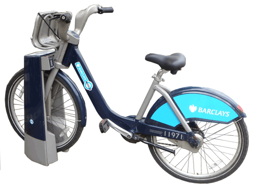
The practical, robust bikes are based on a similar scheme from Canada (‘Bixi’). What they may lack in speed, they make up for in stability, making them particularly practical in crammed central London streets. They have full mudguards, a half-basket to carry your bags, a kickstand, a bell, and dynamo lights which come on automatically.
Before undocking a bike, give the back wheel a spin to check it’s moving freely. If the brakes rub, move onto the next.
Then before pedalling off, adjust the saddle to your preferred height – it’s pretty easy to do, but beware that saddles can and do sink as you cycle along. Tightening the little nut should fix this.
Each bike has three gears, operated by twisting the right handlebar. They’re hub gears, so stop pedalling while you change. If you’re finding it hard going, check you’re in the lowest gear. If the bike’s still faulty, you can swap for another (in the opening minutes of your journey only) by docking it and pressing the ‘fault’ button.
There’s no timer on the bikes, so keep an eye on your watch in case you break the 30-minute limit.
The scheme mostly covers central London, as far north as Camden and south into Vauxhall. In the west, there are docking stations in Kensington and Shepherd’s Bush; in the east, Bow and the Isle of Dogs are the limit.
Do check before going further afield that there are docks in the area. We show docking stations on cycle.travel’s maps, and each terminal has a map, too. If you have a smartphone, there are several Boris Bike apps available which include maps and show you live availability.
The scheme is expanding into Wandsworth and Hammersmith & Fulham in winter 2013/spring 2014. Electric hire bikes are to be trialled in Muswell Hill, too.
By far the most complicated thing about Boris Bikes is the payment system. Once you’ve sussed that, everything else is easy.
You want a key. They only cost £3 and save a lot of hassle at the docking station. Register online to get one – you’ll need your credit/debit card details.
After that, your card will be automatically charged on each day you hire a bike. If you use the bikes often, then switch to the annual fee of £90 – it saves you money even if you only use them four days a month.
You can have up to four keys per account. This is handy for sharing among the family, but bear in mind that each key is charged separately: use two keys on one day, and you’ll be charged two access fees. (You can choose annual, monthly or daily charging for each key, so you could have your own annual key for the regular commute, and a spare daily key for when your partner joins you at weekends.)

570,000 journeys every day – that’s how popular cycling is in London. Almost half the traffic on London Bridge is two-wheeled. Bike shops and cycle cafés are everywhere. Boris bikes throng the streets.
It’s no cycling nirvana, of course, but a big, messy city. On the one hand you have traffic-free towpaths and Royal Parks; on the other, lethal gyratories and four-lane arterials. Just as if you were a cabbie, it's all about the 'knowledge'.
But once you've acquired that knowledge, those days of crowded tubes and erratic buses will seem like a distant memory. Cycling really is the only way to get across London.
We’re building this as a guide to cycling in London. You can already browse the menu for pages about surviving busy roads, Boris bikes, bike culture and more.
But above all, these are your pages, where you can share your London cycling expertise. Use your travelogue pages to post your tips and thoughts on city cycling, and we’ll incorporate the best into this guide.
And if you want to chat and discuss issues with other London cyclists, check out our new London cycling forum.
Panniers are ideal for touring, less so for quick trips around town. Backpacks leave you sweaty. Saddlebags are too small. There must be an easier way…
That was the thought process behind the ‘Transport’ commuter bike, a concept by three students from the Georgia Institute of Technology. Just as a car has a boot, this bike has built-in storage – except here, it’s in the front wheel.
The concept, sponsored by component manufacturer SRAM, is effectively a hubless, hollow front wheel. The storage area itself doesn’t spin, only the wheel around it. You just drop your existing bag into the ‘boot’ and cycle off.
It’s only a prototype so far, and given that it’s made of wood, it’s not a very rideable one either. Still, the student designers hope that it will inspire development of urban bikes.

A new bridge is to be built across the River Thames in Reading for cyclists and pedestrians – but the Reading Cycle Campaign isn’t happy.
The bridge will cross the river north of the railway station, between the two congested road bridges (Reading Bridge and Caversham Bridge) just east of Fry’s Island. It is intended to give a through-route between the suburb of Caversham and Reading town centre, via a new subway under the redeveloped Reading station.
Reading councillors approved the plans on Wednesday. The bridge will be funded by a £20.7m award from the Government’s Local Sustainable Transport Fund, which has paid for several cycle schemes across the country.
However, Reading Cycle Campaign believes the bridge is a missed opportunity. The crossing will be unsegregated shared use, where pedestrians and cyclists mingle. The Campaign believes that there should be separate lanes for cyclists and walkers.
“Essentially the council will be expecting cyclists to ride on the pavement,” it wrote in a statement of objection. “Almost all the riverside paths are already like this, and are for this reason unpleasant to cycle on. There is frequent conflict between users. If we end up with a poorly designed bridge we will have to suffer the consequences for many years to come.”
Separately, Reading Borough Council has launched a consultation on its new cycling strategy. It aims to double the number of people cycling to work by 2019. Comments are requested by 10th January 2014.


Made in the Cotswolds. Published by Éditions Système D Ltd.
Log in with your cycle.travel account:
| Password |
Or simply use your account on:
