Become a supporter

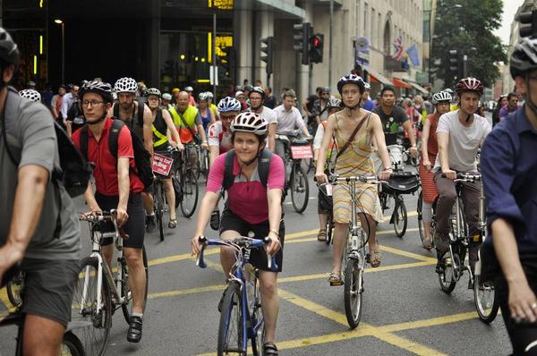
This Saturday, 17th May, thousands of cyclists will be taking to the streets to demand better cycling conditions – while having fun doing so.
The ‘Big Ride’ event, part of the Space for Cycling campaign, follows 2012’s London ride which attracted 10,000 riders. This year, the London Cycling Campaign is hoping to attract even more.
But it’s not just about London: five other cities will be holding Big Rides on the same day. Details are:
London will also have ‘feeder rides’ from locations around the city.
The London Cycling Campaign describes the event as “a fun ride with a serious message, telling politicians we want streets that are safe and inviting for everyone to cycle”. Riders are asked to dress colourfully and bring flags, banners and other paraphernalia. And to emphasise the fun aspect, the rally coincides with the annual Tweed Run, where 500 cyclists dressed in tweed take to the streets on a colourful variety of characterful bikes.
The rides are campaigning for the national Space For Cycling aims:
The Metropolitan Police have confirmed another cyclist has died in London following a collision with a lorry at the notorious Elephant & Castle roundabout. The accident took place at around 4pm today. Though the air ambulance was called, the male rider died at the scene.
The roundabout was described as “a terrible place for cycling and walking” by the London Cycling Campaign. Today’s accident took place at the southern roundabout, which is not proposed for improvements in the current Transport for London programme.

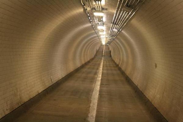
A survey by Friends of the Greenwich and Woolwich Foot Tunnels has revealed wide support for allowing cycling through the two tunnels.
Already, some 50% of tunnel users are cyclists, most of them pushing their bikes. But many cyclists ignore the (largely unpoliced) ban, seeing the tunnels as a safer, faster route across the Thames than the busy road bridges to the west.
56% of respondents to the web-based survey said they thought cycling should be allowed through the tunnels, with only 35% in favour of retaining the ban. A further 9% said cycling should be allowed overnight, so that lone women and other “vulnerable users” could pass through the tunnels more quickly.
However, despite the results of the survey, the Friends say they are not in favour of allowing cycling:
“In our view the tunnels are not suitable for shared use, at least during the daytime when there are large numbers of pedestrians moving through them, including small children and disabled people. In the case of the Greenwich tunnel at least, Fogwoft’s policy is reinforced by the London Cycling Design Standards, which define such things as minimum widths for shared-use paths. The Greenwich foot tunnel is simply too narrow for shared use.”
They do admit, however, that allowing cycling overnight may be possible.
Only 277 votes were cast, which the Friends describe as a “depressingly small” number. They say they will now follow up the opinion poll results with their own recommendations to the Royal Borough of Greenwich.
The Worcester Street/George Street junction in Oxford has long been open to bikes only, with other traffic unable to cross from one road to the next. Roadworks in George Street currently mean that traffic can pass in any direction, with the bike cut-through opened up to all traffic.
Now Oxfordshire County Council is considering making this permanent. The corners would be converted into a ‘shared use cycle facility’, so that (in the words of the Deputy Lord Mayor) “if so many cyclists are jumping red-lights any way, the pragmatic way to deal with that is to design in a safe way of them being able to avoid those red signals in the first place”. Cyclists have, however, given the plan a mixed reception.

We’ve seen some crap bikes in our time, but this takes it literally – yours for $110 (Canadian), a toilet trike. Created as a college art project, it’s more practical than it looks: the seller claims “the toilet seat part is great for carrying groceries”. He also claims that “when I rode this thing around town I was a freaking chick magnet”, which is perhaps stretching credulity a little. It’s for sale on Craigslist if you’re tempted.
Log in with your cycle.travel account:
| Password |
Or simply use your account on: