King's Lynn (0mi/230mi)
The suggested start/end of the route is a town that most car tourists now drive straight past on their way to the coast — unless they get stuck in the notorious summer Saturday traffic jams which cyclists can avoid — and they're missing a gem of an old walled market town, with a medieval Saturday Market Place, Town Hall and Minster at one end of the centre, a Tudor Tuesday Market Place with Victorian Corn Exchange at the other and modern shops along the (no cycling since 2018) High Street between the two.
.jpg)
At the end of the loop, the view entering the town is stunning but the signposted route through the very centre doesn't show you much, so I suggest you keep/turn left when the route signs direct you right near Whitefriars Gate (or Carmelite Arch) and follow the river onto South Quay past the old Hanseatic Warehouses (the only surviving ones in the country) to the Custom House often used as the town's symbol, then keep left to visit the Tuesday Market Place at the end of the road before making a U-turn and letting the one-way system take you to the Saturday Market Place where you can rejoin Route 1 after the Minster to weave between shops, car park and bus station to the rail station.
From the railway station, head towards the nearest church (St John's) and turn left into The Walks, then cross the railway with care and join the Sandringham Railway Path out of town onto a mix of cycleways and fairly quiet roads. From Castle Rising, the route uses the former main road, which is now a popular tree-lined route leading to its replacement, where a cycleway alongside takes you to a crossing on the edge of Sandringham itself.
Sandringham (9mi)
After a mile in the pine forest and the surprising Donkey Pond Hill, a wide drive leads to the visitor centre. Take the first car park entrance and ride round the closed gate ahead if you wish to refill your water bottle. There is cycle parking between the cafe, ticket office and toilets. The Queen's Sandringham House and Gardens is relatively expensive to visit (as is the cafe) but can easily fill half a day if you visit all the museum.
: © David Dixon, CC BY-SA 2.0.")
Once you've seen enough, rejoin the road and follow Route 1 onto rolling small hills past the sawmill and northwards. Keep an eye out for Boston's "Stump" church and Skegness on the Lincolnshire coast (visible across the Wash on clear days), and Snettisham Church with its landmark 52m spire. Snettisham Park Farm's cafe is another good refreshment option near the route, or there are some small shops, a pub and a cafe on the nearby High Street.
Ringstead (17mi) and possible Hunstanton loop
Possible loop: as you enter Ringstead village, there is a gravel car park on the left for a nature reserve which has a picnic area in a former quarry. A gravel road leads through the reserve and eventually connects to Downs Road in Hunstanton, but the town can also be reached by not turning off to follow Route 1 and instead following the main road uphill through the village past the Gin Trap pub, the village stores and the church, then following the road sign to Hunstanton. At the end of that, a few hundred metres left on the coast road brings you to a crossroads where all three ways ahead lead to different parts of the town, with the left arm being by far the quietest while the right is the shortest way to the beach.
.jpg)
After Ringstead, Route 1 rolls along a lumpy ridge about two miles inland from the coast. The riding is fairly gentle and the sea views are good but there is nothing much before Burnham Market. If you need something before then, quiet roads allow loops to visit Thornham Deli, Titchwell RSPB, or Burnham Deepdale cafe and return to the route without riding on much of the busy coast road.
The Burnhams (25-27mi)
Burnham Market, sometimes known jokingly as Chelsea-on-Sea, is the fashionable resort on this stretch of coast. It's annoying to reach by train and bus, so the increasing number of large urban 4x4s has resulted in changes to encourage people to park away from the central green and seasonal stream. A 20mph zone and painted footways have helped to reclaim the area a bit for its cafes and shops, but our route turns right just before entering the green and uses the quieter and picturesque Station Road to head towards sleepier Burnham Thorpe.

Still much smaller, Burnham Thorpe was Admiral Nelson's birthplace, although his nearest statue is in Norwich. The main memorial to him here that you'll see is the village sign, which is almost all about Nelson.
Holkham (31mi)
Two shortcuts are possible at Holkham's back gate: either follow the Route 1 signs forwards to bypass both Holkham and Wells, or continue straight on and instead of turning left ahead, follow road signs for Wighton to also bypass a gravel section.
It is worth following at least some of the Holkham/Wells circular if you have time. Turn left and enter through the awkward gates, if possible (it is sometimes closed and the signs covered) and ride along the avenue to the obelisk, then descend towards Holkham Hall and its cafe and frequent temporary cafe or ice cream stalls.

The signposted route continues down the drive, across the coast road and then over sand to Wells Beach Cafe and back along the harbourside road. Alternatively, if the weather has been wet or it's crowded, or you just don't like sand, you can follow the quieter unsigned road due east just to the right of some woodland and arrive in Wells near its community hospital, but a short ride either way on the coast road will be needed to reach the town centre and head for the harbourside.
Wells-next-the-Sea (35mi)
The westernmost resort actually on the cycle route, the harbour is the focal point of the town with plenty of lunch opportunities, but the misleadingly-named "Picnic Hut" up one of the narrow lanes just east of Route 1 sells excellent crab sandwiches (other fillings are available). A short way further up the hill, the Buttlands offers plenty of green space and benches to eat a picnic in peace or the Crown Hotel and bar as an alternative lunch stop.

Leaving Wells, Route 1 splits into three at Burnt Street. Taking the easternmost (leftmost) branch through Warham to Wighton is advised unless you really like very rough gravel roads, beautiful though they are. At Copy's Green, fork left and follow blue 30 or the circular Norfolk Coast Cycleway symbols.
Jun1999.jpg)
Binham (41 mi)
Notable for Binham Priory (English Heritage - open 9am-4pm or 6pm summer - 1hr guided tour available 3pm Tue/Sun May-Sep) but there is also a Norman market cross on Back Street just off-route straight ahead when the route turns sharply left by the Chequers Inn.

Cromer (61 mi)
.JPG)
Passing under an impressive railway viaduct marks the entry to this busy seaside town known for its pier theatre but the cycle route does not visit the sea front here, due mainly to the esplanade being only a footpath. If you wish to visit the beach, turn left after the Albion onto "The Gangway" to reach the sea, but you will need to return the same way.

The cycle route enters and leaves the town along quieter roads, but it's only to the east of here that the official "Quiet Lanes" start, marked by small direction/information signs on bollards that encourage the few motorists using them to slow down and read.

Mundesley (71 mi)
Small but busy 20mph roads connect the Quiet Lanes to a proper seafront visit in this smaller resort. Take care to turn right onto Beach Road - the cycle route sign is positioned confusingly on the corner of the crossroads, to the right and slightly behind you when heading clockwise. After the small centre, there's a surprisingly sharp very short climb to an old mill as you leave towards Paston and rejoin the Quiet Lanes.

Horsey (91mi)
From Sea Palling to Somerton, the road is busier because it is the only road across the broads near the coast, but it is worth it to ride through the small picturesque village of Horsey and past Horsey Mill (National Trust, tea room open 11-5 summer, picnic area).

Great Yarmouth and Gorleston-on-Sea (100-106mi)
Yarmouth is by far the biggest resort on the route but the main tourist area is well off the route to the west. The need to cross the river gives us excellent views across to the Town Hall and historic riverfront area while riding over the Haven Bridge (cycling on its southern pavement is allowed) and along the working quays of Southtown. Patience is rewarded with a ride alongside the beautiful beach of Gorleston-on-Sea, followed by a short stiff climb up a ravine ramp to Marine Parade. The route then follows quiet roads out to join a cycleway alongside the main road to Lowestoft, heading into Suffolk as we follow its border with Norfolk back west.

Lowestoft (115mi)
The signposted route changes to 1 or 517 here for a brief spell and winds its way along quieter streets and cycle tracks from Corton, but consider heading for the sea front either from Corton (leave the cycle route by continuing straight ahead on the B road and turn left onto Links Road) or when the cycle route turns right to join the old railway (cross the main road, then ride along Station Road, turn right onto the B road and second left at its end onto The Ravine) and visit Ness Point. This is the most easterly point of Great Britain and it is definitely understated compared to Land's End or even John O'Groats, with only a simple memorial.

The drawback of visiting Ness Point is a ride across the neighbouring industrial estate and then either a stiff climb or busy road to rejoin the route in the station area. The next detour has no similar drawback, so it is worth turning left off the route immediately after the bridge and riding across the fountain-filled square to join the seafront cycleway, then start heading inland and look for the B1384 to rejoin route 30 or 517 on the right just before the roundabout, then cross the main road at pushbutton lights.

Beccles (126mi)
A former inland port on a hill overlooking the Waveney, the first river of the Two Rivers Cycle Route. Some of the central streets are closed to cars but still passable by bike, which helps. The marina area just off the cycle route as it leaves town is an ideal picnic opportunity.

The route signs between Beccles and Bungay are the hardest to spot on the entire route, with some only on low posts, but finding them or keeping an eye on the map will be rewarded with some idyllic country lanes and the longest section of the Waveney Valley Railway Path on the route, so it is worth it.
Bungay (133mi)
Another quick visit to Suffolk for almost only as long as it takes to cross this castle town overlooking a bend in the river. One way streets and a bypass have reduced the motor traffic in town, making it a more pleasant place to spend some time.

The main signposted Two Rivers Cycle Route bypasses Harleston to its south, but an alternative route is signposted through it if wanted.
Eye (155mi)
Towns are few on this section of route and the small market town of Eye is worth a look anyway. The town dates back to at least the Roman period despite the name deriving from the Old English word for island and there is a Norman castle nearby. Later, it became a centre of lace-making before it lost importance with the Great Eastern Main Line missing the town to the west and the Waveney Valley Railway far to the north, leaving Eye connected by a small two-station branch line which struggled until it closed in the 1960s.

After leaving Eye, the route narrowly avoids Diss and then heads west through high fens and then heathland to Thetford Forest. Do not be afraid to use alternative road routes through the forest if you are not a fan of gravel and sand tracks. Most of the obvious options on the map are fine.
Thetford (183mi)
A small town that usually tops Norfolk's leaderboard of fines issued to cyclists, so after you reach the castle mount, ignore the cycle route signs which attempt to send you through no-entry and no-cycling streets and instead follow signs for School Lane car park (availing yourself of public toilets if needed after the long stretch from Eye), then take the no-motor-vehicle exit from its far corner and turn right onto a small island. Push over the unusual Y-shaped footbridge towards the hotel, say hello to Captain Mainwaring sat on the bench (Thetford's biggest claim to fame is still the filming of Dad's Army nearby in the 1970s), then join the road to cross another bridge and ride uphill to rejoin Route 30.
.jpg)
Brandon (193mi)
The final visit to Suffolk on the route starts with the lattice bridge over the Ouse (the second of the Two Rivers) into the surprisingly Alpine-like village of Santon Downham and finishes with the small market town of Brandon on the edge of the forest. Where the cycle route joins the main road, most of the shops and the town square are uphill towards the traffic lights, in the opposite direction to the route.
After leaving the town by crossing the Ouse again and the railway, a cycle track on the left takes you to Weeting where the route divides between a southern Little Ouse branch signposted 30 and a northern River Wissey branch signposted (30) until they join Route 11 through Downham Market. I recommend the northern branch, whose first few miles are busier at rush hour but the rest is generally quieter, plus it passes through some picturesque villages and passes the National Trust's Oxburgh Hall. The southern branch is best done with favourable weather because it crosses the exposed Southery Fen on a B road that was recently deleted from the National Cycle Network.

Downham Market (215mi)

Downham sits on the eastern edge of the fens and is visible from many miles away despite not being very high up. The iconic town clock stands in the Pump Square which is only on route 11 when heading south, but it can be visited easily by continuing straight on at the French road sign for Civray instead of turning left into a supermarket car park. After the clock, turn left, then continue forwards at a mini-roundabout and filter left at the traffic lights to rejoin route 11 in about half a mile.
The descent from the old main road onto the fens is a joy with a long distance view over the flat countryside you are entering.
Lord's Bridge (224mi)
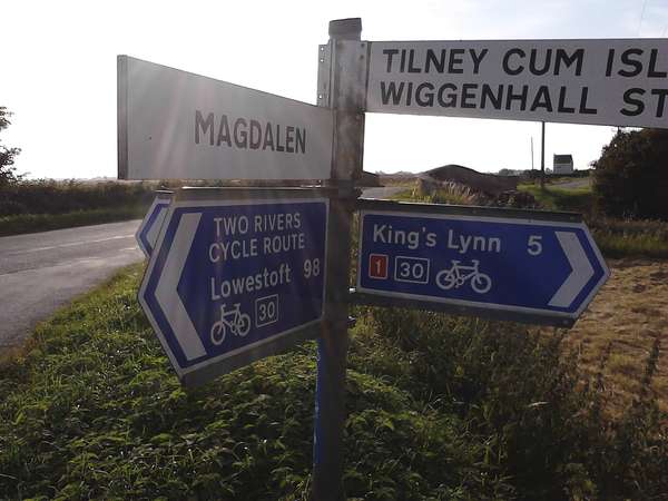
In Watlington, follow signs to the rail station (the cycle route signs are often misplaced) and then continue past, through Magdalen and out onto wide open fens for the only time on this route. The Two Rivers Cycle Route ends on Route 1 by this unusual pair of bridges with a slightly odd sign stating only "Lowestoft 98". There may not be many towns along it compared to the Norfolk Coast Cycleway, but there are a few nearer than Lowestoft! Follow the signs for King's Lynn to complete the journey alongside the Great Ouse (see 0 miles above).