
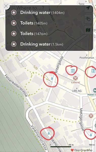
Hi,
Despite nearby water fountains and toilets appearing on the map, the app only lists ones that are farther away.
Screencap from Bad Ragaz, Switzerland. Maybe I’m missing something? Thanks.

Become a supporter
cycle.travel now has Ordnance Survey maps
Plan multi-day adventures easily
Thanks to Swaledale Outdoor Club!
We’re now in Australia and New Zealand too
Stick to tarmac with our new routing option
cycle.travel expands to Scandinavia and Eastern Europe
Smart Turns – new on cycle.travel's route-planner
Hi,
Despite nearby water fountains and toilets appearing on the map, the app only lists ones that are farther away.
Screencap from Bad Ragaz, Switzerland. Maybe I’m missing something? Thanks.


Made in the Cotswolds. Published by Éditions Système D Ltd.
Log in with your cycle.travel account:
| Password |
Or simply use your account on:
Comments
Thank you for spotting that – there’s been a slight change in how some of the mapping is generated and c.t wasn’t picking that up! I’ve worked out what’s happening and a fix will be in the next version of the app (iOS very soon, Android some time September).
Great — thanks Richard.
Apologies for bumping up an old thread, but I noticed a slight difference in how the app handles drinking water taps. The tap I've linked below is shown on the website no problem but not on the iOS app (v2.2), I assume because `access=permissive`? The node was last updated a year ago so it's not an issue with new map data. Thanks :)
https://www.openstreetmap.org/node/12762697950
Also, would you also consider displaying taps with ```drinking_water=yes``` on the website and app? I feel that the current system excludes some helpful permissive taps that could be used for drinking, such as this one by a church in Moffat.
https://www.openstreetmap.org/node/12947495963
Good idea - I’ll take a look.
This may be the same issue that D S reported, but I am still seeing fountains that exist in OSM that c.t website does not show. Example
Also, the app algorithm again doesn’t seem to report drinking water that the app mapping itself recognizes. Image below is Imst, Austria, where several nearby drinking water locations on the map do not show in the list. iOS v 2.2