

Hi, while plotting the established Torino-Nice gravel route, I found that cycle.travel would not allow routing on this segment. I am not familiar enough with OSM to understand why. Bicycles are permitted and I didn't think the surface condition would preclude routing. Perhaps the "very_bad" smoothness? https://www.openstreetmap.org/way/50894205
https://cycle.travel/map/journey/389779
Below is an image of the desired route (in light blue). Any insight would be appreciated, as it will help me to learn how to best use OSM and c.t routing. Thanks!


Comments
It’s actually the sac_scale=mountain_hiking tag (=Swiss Alpine Club classification T2) that’s causing c.t not to route over it. If https://www.dangerousroads.org/europe/italy/4142-colle-d’ancoccia.html is what the trail looks like in reality, the tag looks like a bit of a stretch – maybe sac_scale=hiking (which c.t doesn’t mind) would be more appropriate?
Thanks, that makes sense. Based on Google street view (!) the "hiking" scale does seem more appropriate.
Somewhat-related: how frequently does the routing engine fetch new data from OSM? Sorry if this is covered elsewhere already.
I found the answer to my question above - the routing engine updates monthly from OSM source.
It does (more or less!). I’m due to kick off a new update in the next week or so.
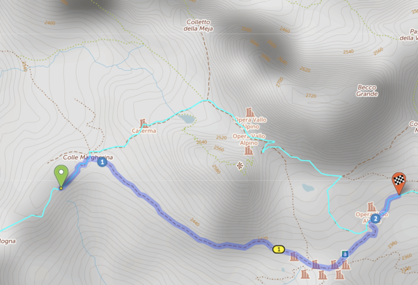
Hi, another question on what's routable and what's not.
In this route , c.t won't allow routing between via points 1~6 pictured below. (I don't even understand why c.t allowed me to create those via points.) On OSM, these trail segments have mtb_scale=0 and sac_scale=2. Even with 'gravel' routing the segments are not routable.
Should mtb_scale=0 segments be routable on the gravel setting (even with sac_scale=2)?
Thanks!
(I recognize that mtb_scale=0 and sac_scale=2 seem contradictory. I guess the question is: which should/does take precedence in deciding 'routability'?)
At present, if there’s any tag that signifies “impassable”, that takes precedence. But having a sac_scale and an mtb:scale that contradict each other isn’t something I’ve encountered before, and we should probably trust the mtb:scale tag over the sac_scale. I’ll have a play with that.
Thanks Richard. I couldn't find a description of how 'Gravel' routing is different, or perhaps I don't know where to look.
Does Gravel routing allow routing on segments that 'Any' routing forbids, or does Gravel routing just weight the surface / tracktype tags differently?
It’s a different set of weightings for everything (tags, elevation, etc.) but generally cycle.travel’s approach is that it’ll allow you along anything legally and physically passable anyway, it’ll just give it a bad weight if it merits it. So in theory everything that’s routable on the gravel graph is also routable on the standard graph, but you might have to try really hard to get it to do so :)
Got it, thanks for the explanation 👍
Hi, another routing/OSM tagging question I'll tack onto this thread.
In this route, I'm unable to route along the north and east ends of the lake as shown in the light blue GPX track. I can't see anything in the tags that should preclude routing here.
Cycle.travel renders them as green ('footpath - no cycling'), but I can't see tags consistent with that. What am I missing? Thanks.
www.openstreetmap.org/way/482710421
www.openstreetmap.org/way/482710424
www.openstreetmap.org/way/482710423
In the UK, cycle.travel doesn’t route over highway=track unless there are access tags like bicycle=yes (or another signifier, like a bike route relation or a designation= tag) to say that bikes are allowed.
highway=track is very often used for private farm tracks in the UK, and routing over them would generally cause an altercation with an angry farmer!
That said, Scottish access laws are different to England & Wales. I’ll have a look at tweaking this for Scotland, but as a general rule of thumb in the UK it’s best to add access tags.
Thank you. I do now recall seeing something about this on your help pages - apologies for the duplicate question.