
Strange behaviour on this route: https://cycle.travel/map/journey/182694
When I first open the route, it skirts west of Banbury:
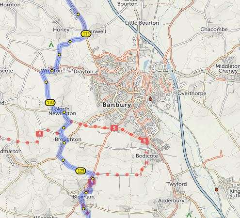
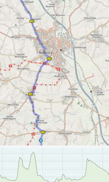
But then if I open the elevation pane, my route changes. It now goes through Banbury.

Become a supporter
cycle.travel now has Ordnance Survey maps
Plan multi-day adventures easily
Thanks to Swaledale Outdoor Club!
We’re now in Australia and New Zealand too
Stick to tarmac with our new routing option
cycle.travel expands to Scandinavia and Eastern Europe
Smart Turns – new on cycle.travel's route-planner
Strange behaviour on this route: https://cycle.travel/map/journey/182694
When I first open the route, it skirts west of Banbury:
But then if I open the elevation pane, my route changes. It now goes through Banbury.


Made in the Cotswolds. Published by Éditions Système D Ltd.
Log in with your cycle.travel account:
| Password |
Or simply use your account on:
Comments
There is an explanation but I agree it’s a slightly odd one!
When you click the elevation button, cycle.travel goes back to the routing server and says “give me this route again, but with elevation information”.
The issue here is that, since you originally planned the route, a new cycle path has been built beside the A361 between Bloxham and Banbury… and cycle.travel rates traffic-free, tarmac paths highly. So it now thinks that the best route between via points 7 (Edge Hill) and 8 (Hempton) is via this new path, and on re-fetching the route with elevation, it goes that way.
If you want to keep the previous route, you can just add an extra via point somewhere on the old line (e.g. at North Newington) and then open the elevation.
Thanks Richard.
If I wasn't watching closely, I might not notice that the route has changed. I'm not sure what the solution is here, but it's good to be aware that this can happen.