
Become a supporter
Hello,
I recently road in the UK by following routes suggested by Cycle.travel. I knew A roads were to be avoided at all cost, but even B roads were crazy to ride on with drivers passing very close and very fast :-/
Unless I missed it, it doesn't look like the router lets users choose to avoid riding on A/B roads. If it so, I suggest adding this feature.
Cheers,
Hello,
I think it'd be useful if C.T. showed steep hills as waypoints à la IBPIndex, as a way to plan for shorter days in hilly areas.
Cheers,
Hello,
While C.T. can display elevation data after drawing a route and hitting the "moutain" icon on the left, unless I missed it, it doesn't include elevation data in the output file. I had to use GPSVisualizer's to gather them from some other server and append them to a new GPX file:
ORIGINAL
<?xml version="1.0"?>
<gpx version="1.0" creator="cycle.travel"
xmlns:xsi="http://www.w3.org/2001/XMLSchema-instance"
xmlns="http://www.topografix.com/GPX/1/0"
xsi:schemaLocation="http://www.topografix.com/GPX/1/0 http://www.topografix.com/GPX/1/0/gpx.xsd">
<rte>
<name>Rennes to Le Ma</name>
<rtept lat="48.11133" lon="-1.68024">
<name>Ruedel'Hor</name>
</rtept>
<rtept lat="48.10934" lon="-1.68016">
<name>RueduPréBo</name>
</rtept>
</rte>
</gpx>
ELEVATION DATA APPENDED BY www.gpsvisualizer.com/elevation
<?xml version="1.0" encoding="utf-8"?>
<gpx version="1.1" creator="GPS Visualizer http://www.gpsvisualizer.com/" xmlns="http://www.topografix.com/GPX/1/1" xmlns:xsi="http://www.w3.org/2001/XMLSchema-instance" xsi:schemaLocation="http://www.topografix.com/GPX/1/1 http://www.topografix.com/GPX/1/1/gpx.xsd">
<wpt lat="48.11133" lon="-1.68024">
<ele>46.8</ele>
<name>Ruedel'Hor</name>
</wpt>
<wpt lat="48.10934" lon="-1.68016">
<ele>36.7</ele>
<name>RueduPréBo</name>
</wpt>
<trk>
<name>Rennes to Le Ma</name>
<trkseg>
<trkpt lat="48.11133" lon="-1.68024">
<ele>46.817</ele>
</trkpt>
</trkseg>
</trk>
</gpx>
Cheers,
Hello,
Unless I missed it, it seems like Cycle.Travel doesn't let users add legs to a trip.
For instance, I wanted to ride from Rennes to Vitré, and then up to Fougères:
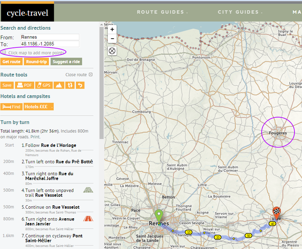
I tried the "Click map to add more points", but it draws routes in a straight line instead of following roads.
Is there a work-around, short of saving each leg in an independent GPX file and merging them all with eg. GpsBabel?
Thank you.
Hello,
I suggest moving the "switcheroo" icon/feature next to the from/to items à la Google Maps to make it more obvious to users: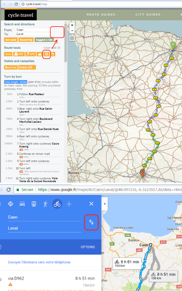
Cheers,


Made in the Cotswolds. Published by Éditions Système D Ltd.
Log in with your cycle.travel account:
| Password |
Or simply use your account on:
