
Become a supporter
Hello,
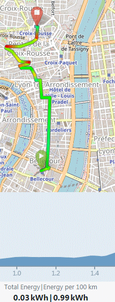
Unlike CT, BRouter doesn't show how steep a road is at such and such location, but it does compute how much energy is required for the whole trip. I suggest adding this feature, as it's especially useful when considering buying a cargo bike.
Cheers,
Hello,
I notice Cycle.travel, along with OSRM and BRouter (and the OpenCycleMap map), ignores one-way streets with contraflow bicycle lanes/tracks that are tagged with either "cycleway:left=opposite_lane/track" or "cycleway:right=opposite_lane_/track". It only understands "cycleway=opposite_lane/track".
As a result, cyclists are made to take a long detour needlessly.
The cycleway:(left|right) key is especially easy to add since this is the tags Id uses by default when editing OSM through a browser (you have to manually edit it to remove the ":left|right" part). But then, contraflow lanes/tracks are pretty rare in OSM, possibly reflecting their rarity on the ground:
https://taginfo.openstreetmap.org/keys/cycleway%3Aleft#values
https://taginfo.openstreetmap.org/keys/cycleway%3Aright#values
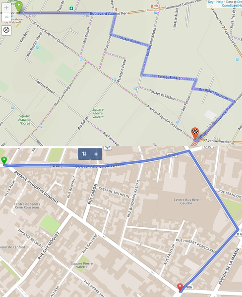
Here's an example in Cycle.travel and OSRM (avenue Augustin Dumont is tagged with "cycleway:left=opposite_lane"):
This seems to me like a serious issue.
Cheers,
Hello,
I suggest adding a Permalink somewhere when using /map so that users can share a route without having to 1) register and 2) save it. BRouter offers this, and it's pretty useful.
Even better: The URL should be short, so that it can be shared by eg. email without having to use a third-party like Bit.ly.
Cheers,
En passant par le Pont de Puteaux puis la Passerelle Jean Moulin, soit La Défense par la face sud sans mettre pied à terre
Hello,
When preparing a trip, I start by building a new map of things to see in Google My Maps (because its search engine is much better than OSM):
But since GMM's router is pathetic, I have to open a second tab where I'll use Cycle.travel to build routes to reach all those waypoints, switching back and forth with (SHIFT+)CTRL+TAB. It does the job, but is a bit cumbersome.
My suggestion: Make it possible to upload a file (GPX or KML: GMM only exports as KML) as an alternative to an empty map to get started.
Cheers,


Made in the Cotswolds. Published by Éditions Système D Ltd.
Log in with your cycle.travel account:
| Password |
Or simply use your account on:
