
Become a supporter
Another scenic loop from Lytham St Annes. Flat start and finish, hilly in the middle. Be careful on the descent off Waddington Fell - there are sometimes sheep wandering across the road. I also got caught out on one bend by going in too hot!
A nice loop from the flatlands to the lovely Trough of Bowland and back. Easy start and finish, and lumpy in the middle.
Hi Richard.
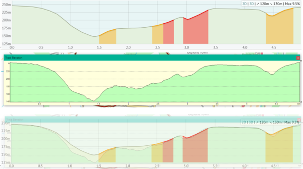
I find the elevation profile display can be a pretty rough approximation to reality at times. I was looking at a hilly little loop which I was going to simulate in Training Peaks Virtual. The loop includes a very steep descent into a dip at Mill Bank and a very steep climb out of the dip. Your elevation display smoothed all the difficulty out of it, claiming the maximum gradient to be 9.5% whereas in reality it is closer to double that! I would have been really caught out if I had chosen that road expecting less than 10% gradients.
This is the loop in question: https://cycle.travel/map/journey/894967
I have drawn the same loop in my old Memory Map software which uses OS mapping. The profile that came up with is much more like the real thing. The picture below shows the 2 profiles separately and then overlaid to make the difference obvious.
I have also noticed that your maximum gradient figure is often less than the figure that the software displays on the profile itself. Example below...
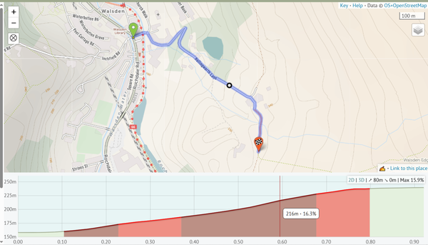
Max 15.9% but 16.1% shown on the climb itself! That is only a small difference but I have seen the max being displayed as being 5+% less than reality.
Do you think that you could improve the accuracy of the gradient figures and the elevation profiles?
I reported one dog leg junction turn by turn navigation problem in Devon a while back and that got fixed.
I just discovered another interesting one in the backstreets of Todmorden!
This route snippet goes along Stansfield ROAD, turns left down Wellington Road, then immediately right along Stansfield STREET. Cycle.travel is treating it as one road, apparently missing the junction altogether.
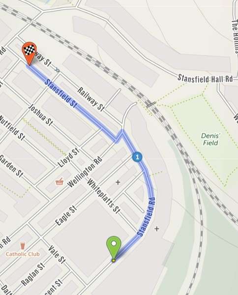
No cues are generated for the 2 turns.
Perhaps missed because the turns are so close together AND the first and last road names both begin with 'Stansfield'?
I sometimes notice that the combination of OSM/cycle.travel/my Wahoo Elemnt Bolt v2 doesn't handle parts of routes correctly but I don't know which is to blame!
I will give examples like this as I notice them.
Fortunately, I am familiar with the roads below because there was no cue at the crossroads at 1 km so I would not have had a clue which way to turn. I was just told at the start of the lane that the next cue was in 3 km time, which was after passing through the next village. I did not have priority at the crossroads - white lines to cross so I couldn't just follow the direction of the road. It probably isn't relevant (?) but the road opposite is no-through.


Made in the Cotswolds. Published by Éditions Système D Ltd.
Log in with your cycle.travel account:
| Password |
Or simply use your account on:
