
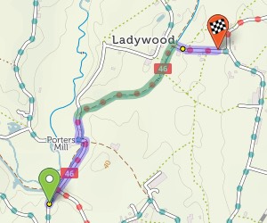
There’s a handy map key (or legend) that shows you what the road and symbol colours mean. Click the link at the corner of the screen, by the credits.
When you’ve planned a route, it’s highlighted in blue and green on the map. Blue for paved sections; green for unpaved.
You’ll see summary statistics on the left. These show how much there is of each road type:
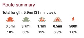
From left to right: busy road, other road, paved cycleway/trail, unpaved trail, pushing section.
The ‘layer’ icon on the map allows you to switch to the OpenStreetMap map style, which is less clear but shows more features.


Made in the Cotswolds. Published by Éditions Système D Ltd.
Log in with your cycle.travel account:
| Password |
Or simply use your account on:
