
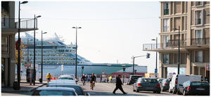
Le Havre At the mouth of the Seine, Le Havre is a ferry port of some antiquity, though at present the Brittany Ferries service from Portsmouth doesn’t take bikes unless on top of a car. Regardless of whether you arrive by ferry or train, you’ll want to head for the Boulevard Winston Churchill: the roadside cycle path is where the V33 cycle route begins.
The scale of the Le Havre port is something to behold. Not so much the town docks which you’ll pass at first, but the vast shipping complex that makes this France’s busiest container port. The result is that you won’t actually see the Seine until Tancarville, 45 (easy) kilometres into the journey. Instead, you follow good-quality cycleways at first, then the old road that has largely been supplanted by the parallel autoroute – still a bit busier than would be ideal, but tolerable.
The suspension bridge at Tancarville is an arresting sight; the port canal rejoins the Seine here. Industry hogs the riverside here, so your acquaintance with the Seine will be brief. The diversion inland is worth it for the pleasant town of Lillebonne with its extensive Roman remains.
Alternatively, if you’re approaching from the west (perhaps having taken the ferry to Ouistreham/Caen), you can enjoy the south bank route signposted V33b. This begins at the delightful old port town of Honfleur, without doubt a more attractive setting than Le Havre itself. Continue on quiet roads to Quillebeuf or Jumièges, where there are ferries to the north bank.
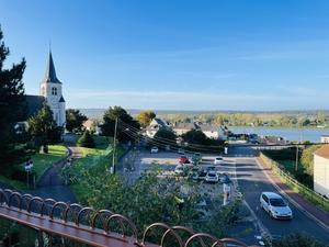
Port Jérôme (43km) At last, after Port Jérôme, the north bank route heads purposefully for the riverside on a tiny road across farmland. It clings to the shore through the pretty river-facing town of Caudebec en Caux. There’s a fascinating river museum here, MuséoSeine.
Saint Wandrille Rançon is just off the route, but worth the 1km detour for Fontenelle Abbey – a centre of learning for some 1500 years, and still an active monastic community despite the buildings being half-ruined. The third of the Seine’s great suspension bridges, the Pont de Brotonne, crosses here.
From here an outstanding railway path takes up the route, all beautiful smooth tarmac with benches for recuperation. The tree cover breaks for views over the sprawling ship-building town of Le Trait towards the river. It’s the most enjoyable part of the route so far. You can continue on it all the way to Duclair, but the main Seine à Vélo route loops south on-road after Le Trait to head for Jumièges.
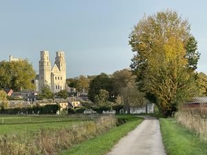
Jumièges (81km) Once the grandest monastery in all of France, Jumièges Abbey has been, since the Revolution, the grandest ruin. An astonishing amount is still standing, including the roofless church, cathedral-like in its scale. There’s a cyclist-friendly guesthouse and creperie directly opposite the abbey, a campsite nearby, and a couple of restaurants in town, making this a good overnight location.
Observant cyclists may have spotted the ‘Route du Bac’ a few miles earlier, a ghost road leading down to the site of one of the many ferries that once crossed the Seine. Bridge construction has cut their number, but a few still run – most commonly at 20 minute intervals though with occasional breaks. One of them is at Port Jumièges, where the V33b south bank route joins the main route: excellent food is on offer at the adjacent auberge.
From here, the route settles into a pattern of gentle country lanes past orchards and smallholdings. The river is never far away, yet often just out of sight. Another ferry, at Le Mesnil sous Jumièges, takes the route back to the left bank but the character of the lanes doesn’t change much. There’s an unexpected climb and sharp descent after Ambourville, where the road is lifted to the top of the cliffs for a few kilometres.
The D93 from here is a little busier, but it’s a fabulous road, clinging close to the riverside. One of the joys of the Seine in Normandy is the variety of houses – half-timbered, brick-built, modern concrete. You’ll see them all along here, particularly at the pretty port village of La Bouille, where a ferry takes you over to the right bank.
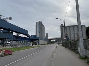
Sahurs (118km) From Sahurs to Rouen is a fascinating ride. Not always classically pretty – perhaps even a little wearing at times. But in just a few kilometres, you’ll see all the changing character of the river.
It begins with a riverside cycle path, peacefully following the right bank of the river. It would be a glissando-smooth ride were it not for the fallen apples and hazelnuts that litter the way. Châteaux adorn the first few kilometres: Trémauville, Soquence, Hautot, all built for the local nobility in the 18th century.
Glance across to the left bank, though, and you’ll see all the trappings of modern river industry: vast sea-going vessels moored up at sturdy wharves, river barges waiting for their upstream cargo, cranes, warehouses, stacks of containers. Rouen, the capital of Normandy, sprawls along the Seine, and these modern docks have long since replaced the city wharves as the centre of commerce.
At Val de la Haye, a ferry crossing marks the beginning of industry here on the right bank. The attractive riverside cycleway is replaced with a grimier roadside path, past the great grain silos and cereal mills that send Normandy’s arable out across Europe. Incongruously, along here is the Pavillon Flaubert – a little garden pavilion, all that remains of Gustave Flaubert’s riverside house. A final detour along the roads around the Saint Gervais river basin takes you to Rouen’s waterfront proper.
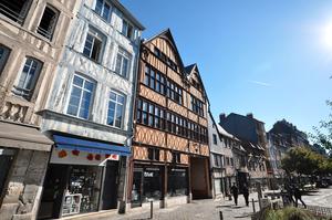
Rouen (135km) Rouen needs no introduction. The capital of Normandy, it boasts a breathtaking cathedral – as painted by Monet – and a castle, art galleries and museums. But the main appeal is its medieval streets, with some 2000 half-timbered houses, many beautifully restored. If at all possible, plan your trip to include an overnight stay here: hotels are plentiful, though the main campsite is out of town.
You’ll enter along the regenerated riverfront, now the chosen mooring for opulent cruise liners rather than sailing ships, and dotted with bars and restaurants. The signs take you back and forth along both banks as if to ensure you pay attention to the city. It’s only a few metres’ ride from the Pont Boieldieu, where you cross the Seine, to the cathedral.
Here we leave the Seine for a while. It’s a long, slow, uphill drag along suburban roadside cycle paths – several of which are currently (2022) being upgraded. The route takes you through the suburbs of Le Petit Quevilly and Le Grand Quevilly, the latter of which seems to comprise mostly drive-thru fast food restaurants.
After 3.5km, the route finally leaves the busy roads for the Forêt de Rouvray. A remnant of the woods that once covered this part of France, it’s blissfully quiet after the clamour of Rouen. Just two turns on straight forest rides take you towards a steep descent and the riverside town of Oissel.
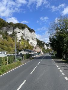
Oissel (150km) Oissel is an uneventful town, particularly on the cycle route’s chosen course through residential areas. But what follows is truly dramatic: the valley road of the Route des Roches. Giant stacks of white overshadow the deep green river meadows, with sought-after residences nestling below the cliffs.
A rather precarious footbridge beside the railway bridge briefly takes you over to the right bank, before crossing back again to the industrial town of Elbeuf – which actually has some fine buildings akin to Rouen’s if you venture into the centre. For our money the real charmer is little Criquebeuf sur Seine, a strung-out village delightfully preserved and unspoilt by traffic. You’ll reach it by a path alongside the river Eure, a tributary of the Seine that runs parallel for the first few km. There’s riverside camping at Pont de l’Arche.
Route V41 peels off along the River Eure into the 1970s new town of Val de Reuil, which has little tourist appeal except for devotees of 20th century architecture. Our V33 follows the Seine via Poses, location of the first lock on the river and a lovely narrow waterfront avenue. From here through Saint Pierre du Vauvray to Les Andelys, the agricultural landscape is dotted with lakes formed by gravel extraction. It’s easy riding as you follow the meanders in this twisty section of the river.
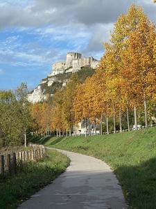
Les Andelys (204km) The Seine can’t match the Loire for châteaux, of course. But it has its moments, principally Château Gaillard at Les Andelys. Standing high above the river on the clifftop, the medieval ruin is of classic concentric design, making the most of its commanding position. A tourist destination for many years, the village is a charming jumble of shops and restaurants, and worth the 2km detour from the bridge.
New cycle paths thread the route south towards Courcelles sur Seine. From here, the Seine à Vélo is decidedly unfinished in a plot straight out of the Asterix books. Since 2018, the villagers of Pressagny l’Orgueilleux – a fairly inconsequential village with tenuous Monet connections and a population of just 700 – have been squabbling about the arrival of the cycle route since 2018. Local dignitaries have implored, cajoled, pleaded and lectured, but to no avail thus far. Just like the “little Gaulish village” facing off against the Romans, this hold-out is the one settlement stopping the whole entreprise being completed. This article (in French) has all the gory details.
The aim is for a riverside cycleway along here, but for now, it dodges Pressagny on farm roads before a 5km stretch on the busy(ish) D313 to Vernon.
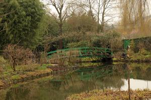
Vernon (224km) Harmony returns at Vernon, a busy town with a mixture of architectural styles, situated on the south bank of the river (there are cycle lanes on the bridge). The main tourist attraction is, of course, Monet’s garden at Giverny, a few kilometres further on. To see the same vistas made famous in painting is a startling, almost unsettling experience. The garden is predictably popular, so if you intend to visit, book your tickets in advance: the queues are notorious. Inexplicably, the signposts take the route along the main D5 past the village. Ignore them, and turn left at the roundabout to cycle – slowly! – through the centre of Giverny on the Rue Claude Monet.
A traffic-calmed D road nestles under the cliffs for an easy ride on to La Roche Guyon, where the 12th century fort towers over a manor house used as Rommel’s headquarters in WW2. At the next village, Haute Isle, the signposts take you through a field for no discernible reason before rejoining the main road: it’s fine to ignore them.
Finally, at Vétheuil, we leave for a patchwork of minor roads tracing the extravagant meanders of the Seine. At Méricourt, a gravel pit has been repurposed as a marina and port de plaisance, while a hydroelectric barrage makes good use of the drop in the river. The concrete surface along the wooded path is a little more jarring; the unsurfaced riverside path into Mantes la Jolie is narrow and can be very slippy after rain, so do consider diverting onto the parallel main road.
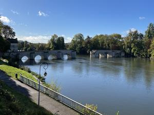
Mantes la Jolie (282km) Reputedly named “la jolie” after Henri IV’s affectionate diminutive for his favoured mistress, Mantes is a friendly provincial town best known for its towering church of Notre Dame (not actually a cathedral, but it deserves to be).
The route assumes a more prosaic character from here. Farewell châteaux; your companions now are power stations, river ports, rail yards and a Renault factory. It’s not uninteresting, and there are some enjoyable riverfront paths around Les Mureaux where you’ll be rubbing shoulders with pleasure boats. But we don’t think this leg will be the highlight of anyone’s tour.
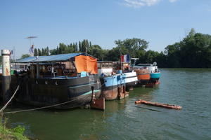
Conflans Sainte Honorine (328km) Conflans is exactly what it sounds like: the confluence of the rivers Oise and Seine. The town is the capital of French barge life, with a waterway museum and dozens of moored houseboats. Commercial barges ply the slow-flowing Seine night and day, loaded with coal, tanker liquids and containers, all with living accommodation on board and a little Citroen parked on the back deck.
Here we meet the Avenue Verte London–Paris (V16). For much of the entrance into Paris the routes run in common, but to begin with, the Avenue Verte takes a short-cut through the forest of St Germain while our V33 follows the river on residential roads with seemingly endless speed bumps. After the twisting route through Normandy and the outer suburbs, the route cleaves closer to the Seine here, rarely more than a few metres away.
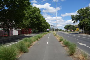
Rueil Malmaison (355km) Rejoining the river at Sartrouville, the route follows good quality bike paths along the right bank, then crosses to chic Rueil-Malmaison where there are cafés around a new square. The comfortable track takes you to the decidedly less chic port area, where a footbridge over a backwater is so steeply ramped (to preserve navigable headroom) that lifts have been provided for bikes!
At Argenteuil, the route heads inland on the busy Avenue de Stalingrad. In theory the passage through the port area of Gennevilliers follows segregated cycle lanes. In practice, parked lorries can block the route, and you may find it easier to stick to the road. Take care near the new tramway, where your wheels may fall foul of the tracks or the subtle ramps up to platforms.
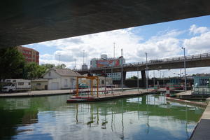
Saint Denis (373km) Like London, Paris has its urban canals, but the sheer size of the Canal St Denis is a world away from the little Regent’s Canal. The bumpy towpath gives a good insight into this multicultural area. Extensive regeneration projects are underway, so don’t be surprised to be diverted off the towpath now and then.
The St Denis meets the Canal St Martin at a T-junction. Turning right here, past an area used for the annual ‘Paris Plages’ (Paris Beach) summer festival, speeds you along segregated lanes into central Paris. The final approach to the Seine is along the Rue St Denis, a pedestrianised shopping street where cycling is permitted but, frankly, impossible due to the sheer number of walkers. You may find it easier to brave the parallel roads, or simply push.
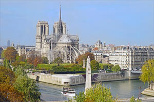
Paris (385km) Fin de la route? That rather depends whether you’re continuing above Paris. But if not, the Île de la Cité is a predictably grand setting to end your tour, in the shadow of Notre Dame. This is the classic view of the Seine… but you’ve seen it change through its many facets, all the way from the Channel.
So why not keep going? Route V33, shared with EuroVelo 3, continues directly along the riverbank, as the bustle of Paris slowly subsides and a gentle suburban peace returns. After Corbeil Essonnes, the Seine has well and truly shaken off the city. The tree-lined, sometimes gravelly towpath here provides some of the most relaxing moments of the ride.
Melun is an interesting historic town, spanning not just both banks of the river but an island as well. Or for true opulence, you could visit the Château de Fontainebleau, occupied by the French monarchy from medieval times through to the Revolution.
Champagne sur Seine (482km) In contrast, there’s nothing that special about Champagne sur Seine. But this is where the Seine cycle route finishes for now. In time, the route will continue along the canal towpaths of the Seine valley. The last section, along the Canal de la Haute Seine into Troyes, is complete already – but there’s a substantial lacuna between Champagne sur Seine and there.
So for now, catch the train back; there are suburban rail stations on both banks. Before you leave, take a look at the cheerful pleasure boats that throng this stretch of the river: passenger cruise boats, converted péniches, fibreglass cruisers and lovingly restored wooden craft. It’s a long way from the massive port of Le Havre, its expanses of tideway and ocean-going ships. There’s something quite special about cycling the course of a river, and it’s something France does particularly well.
Log in with your cycle.travel account:
| Password |
Or simply use your account on: