
Become a supporter
Just a suggestion that I think would be very helpful. A zoomed in window, either just at turns, or all the time.
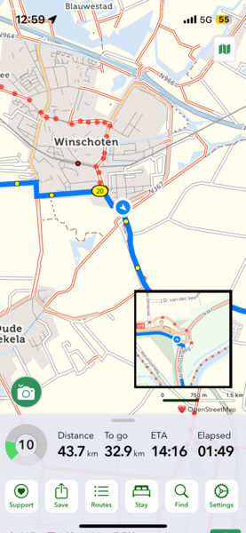
Made a very quick mockup of what I mean:
They're nearly the same color and it's sometimes confusing (e.g. around Rotterdam)
I have about 50 app store accounts (Apple makes it almost impossible to change countries so I just make new accounts instead)
CT is literally my only subscription, and it gets disabled all the time because of this. Is there any way to fix it? I’d be happy ton just purchase a lifetime license or whatnot :)
Thanks for making such an awesome app! I compiled a list of stuff that would be nice to have/a few bugs instead of making a million posts.
Elevation profile on desktop
- show day markers. It currently shows the days, but it’s either in the middle. You can’t tell where the start/end points are
- The box showing the altitude is weird. It shows the altitude at the mouse cursor, not at that point on the route
Mobile/General
- Add ability to add multiple specific places. You can search for “123 main st” and get directions to there, but you can’t search for an address for day 2 or 3 or 4 and make a long route like you can on desktop.
- Move the elevation profile off to the side in landscape mode
- There seems to be a positioning bug on iOS with the distance, to go, etc. info. The last two sometimes disappear, with “to go” being where ETA normally is
- Option to zoom in on elevation profile
- It would be nice to see how many km are remaining for the day. I know you can split routes into multiple days, but then I have 100 routes. I’d rather have “Berlin-Paris” or whatever.
- Option to navigate via the shortest/quickest path. Because sometimes you’re just tired. Or it’s about to rain.
- Option to highlight/exclude ferry crossings. Twice in Poland I had to make long detours because the ferry didn’t actually exist (not CT’s fault), and it’d be nice to be able to see those without having to zoom into every river and try to figure out if it’s a ferry crossing
- Being able to navigate via, or see, bike paths would be really nice. I don’t mean routes like EV, but actual paths.
- One random map tile occasionally flickers to black and back really fast


Made in the Cotswolds. Published by Éditions Système D Ltd.
Log in with your cycle.travel account:
| Password |
Or simply use your account on:
