
Become a supporter
Hello Richard, while planing a multiday trip, I noticed that gradient display (in the 2d view) breaks.
for instance on this route: https://cycle.travel/map/journey/306662 around kilometer 190, it doesn't show any color, and the tooltip on the line of the 2D view doesn't show the percentage like it usually does (can't screenshot the tooltip as it disapears). however this is actually a very steep climb albeit for my touring standards.
Now if I draw only that segment of the road in a new tab, it show correctly ( https://cycle.travel/map/journey/316733 ):
while experimenting I've noticed the tooltips start to break at around 150km as for the coloring, I haven't really found a logic as to when it breaks. Also note that zooming in on the elevation chart doesn't help.
hope this helps!
Hello, after intensively using Cycle.travel this summer I've gathered a small list of quality of life features I think would help my workflow and maybe other's as well!
1. share without saving. I often find myself brainstorming a route ideas with friends or recommending a route to someone. It would be nice if I could just plot the route then click "share" to get a (semi)perma-link to it without having to save it to my already large and disorganized list of routes.
2. Search Location without modifying the current route.
I often found myself looking for a small village or sight mid route and wishing I could just search for it and have a marker added to the map without breaking the route. For instance when some random person on the road tells you "you should take the route through X it's really lovely!". Maybe I just haven't found that feature yet but currently the only way I found was to add a via point or change the from/destination. which effectively breaks everything (especially if you don't know already know where that place is. I think in general it would be great to have the option to flag spots around a route for further reference, maybe even with a label.
3. Show elevation on the route as a color gradient. Especially on mobile, I think an option to display the elevation on the route (as shown on the linked https://imgur.com/a/bJnzK9n) would be great as the 3D view is but really cumbersome on a small phone.
Once again thanks for weeks of stressless cycling along gorgeous roads this summer!
Hello
I really love the new multi-day planing with overnight stops. Having the distance counter reset every day is very practical to pace the trip. However I can't find a way to view daily elevation. Am I missing something in the UI? Or would it be possible to add that info somewhere ? maybe in the elevation panel. or more broadly allow selecting slices of the elevation pannel to view local elevation.
Right now as a work around I'm spliting the trip day by day to view the daily elevation but that's not very practical
love your work
Thanks
Hello,
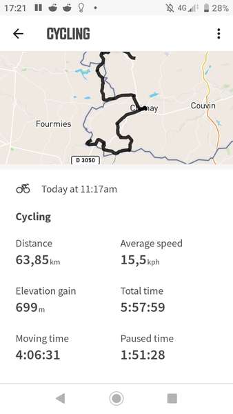
I've noticed high discepencies between the elevation gain shown on cycle.travel and the one recorded by my wahoo roam. for example in this trip https://cycle.travel/map/journey/217164 CT gives me 410m gain. while my wahoo gave me 699m gain. and I'm inclined to believe to later judging by the states of my legs :)
I've been traveling a lot around Belgium using cycle.travel but have only noticed this issue recently. the difference is sometimes up to a factor of 2.
I understand this might be due to the resolution of the elevation data but it makes planing a bit more hazardous. Has anyone else noticed this ? Or could there be an issue with the belgian elevation data specifically?
anyway thanks for the amazing website.


Made in the Cotswolds. Published by Éditions Système D Ltd.
Log in with your cycle.travel account:
| Password |
Or simply use your account on:
