
Become a supporter
Hola!
Can you elaborate on the difference between Private & Public markers, please?
I've played around a little and I'm not sure of the difference. For example, I've saved a marker as "Public", saved a route with that marker (Public), gone incognito (Chrome) and do not see the marker either on the map or when I open the (public) route.
The Patreon email suggests that the difference between Public & Private will become more distinct in the future. I'm just wondering if by adding markers now that are public will I be in danger of cluttering up the map for other users down the road? (Most of the things I'll be marking will be, how shall I say it .... eccentric :-) )
In a similar vein, I have placed three Markers close together, one saved to the route, one public, one private. I can see all three when I open the route, can see two when I open the map (not the one saved to the route) but when I open the map for a folder that contains this and other routes none of the markers display on that map. It's not a criticism, not a feature request just some feedback.
When this becomes available on the app it will be incredibly useful to travellers to mark off places that interest them live along the way. I've often stopped to add a POI on Osmand for some special place - this will be so much easier!
Hope you get out yourself for Easter!
I've been unable to properly dig into the app. First of all it was too hot :-) and my phone overheated. I picked up a cheap holder on the road but it's rubbish. I'm not going to use a phone on the handlebars regularly but would like to give the app a good run out so can anyone recommend a decent, secure holder for an android phone, preferably one that is adjustable for different phones. Security of the phone on the bike (I like the rougher stuff) is more important than being able to easily remove the holder. I don't want to spend a fortune - money is tight and I much prefer my gps unit - but I do want to play with the app.
Many thanks in advance.
Hi Richard, I've just noticed something and thought I'd bring it to your attention.
On the "my Journeys" page if I wish to download the GPX/TCX file I normally use the Download icon, then select "More Download Options"and choose the option I want. However, now I see that two options are "greyed out" (GPX route, small file etc. & TCX course).
If I open the map and try to download from the map then all options are open to me.
Strangely, I don't have this issue with older files - it seems (and I may be wrong) to only affect newer routes. Checking a route created in December (22) can be downloaded as "normal" but a route created in January (23) has the greyed out options.
This applies to my android phone and Chromebook, both running Chrome.
This is not a big deal for me because I can still download my preferred option (TCX course) from the map screen but it may be confusing or frustrating for some users.
As always, my gratitude for such a great tool
There are a whole load of features on CT to help us plan a great bike tour but there is also a feature that we can use to look back on a great bike tour.....
If we organise our routes in one folder, we can display them on a map like this....
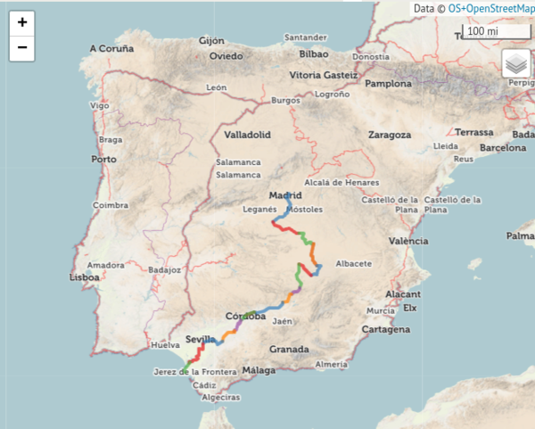
But..... we can also change the map..... like this.....
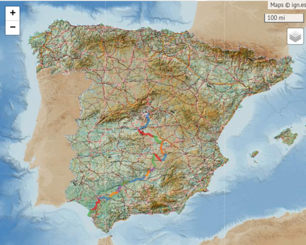
Or even ......
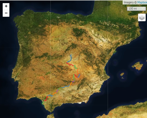
(Sorry for taking up the server space!)
This is a test note
I can access it anytime under "my posts"
I can edit it too at anytime by going to my posts


Made in the Cotswolds. Published by Éditions Système D Ltd.
Log in with your cycle.travel account:
| Password |
Or simply use your account on:
