
Become a supporter
The Loire Valley, a UNESCO World Heritage Site, boasts a rich cultural landscape and numerous castles and palaces. The Loire à vélo cycle route offers a pleasant journey with amenities like cyclist-friendly places and clear route markings. The region’s history and cuisine make it a popular destination for cyclists and tourists alike.
www.cyclingthread.com/alpe-adria-bicycle-route-cycling-through-alps-to-adriatic-sea
The Alpe-Adria Bicycle Route is a popular trans-Alpine cycling route spanning 415 kilometers through Austria and Italy. The route offers diverse landscapes, including the Berchtesgaden Alps and the Julian Alps, with a comfortable and safe journey. Cyclists can explore attractions like the Silent Night Museum, Hofbräu Kaltenhausen brewery, and the Eisriesenwelt ice cave.
Hi,
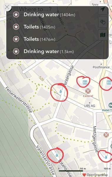
Despite nearby water fountains and toilets appearing on the map, the app only lists ones that are farther away.
Screencap from Bad Ragaz, Switzerland. Maybe I’m missing something? Thanks.
I just finished 3 weeks cycling in the UK, where I think I was using the cycle.travel website and app about 12 hours per day :) The route browser map — and maps of my own route folders — were so useful for planning, and of course the routing engine itself is brilliant.
A few comments on using the iPhone app for several trips over the past year.
I really love planning routes and riding them with the site and app. Thanks for making it possible!


Made in the Cotswolds. Published by Éditions Système D Ltd.
Log in with your cycle.travel account:
| Password |
Or simply use your account on:
