
Become a supporter
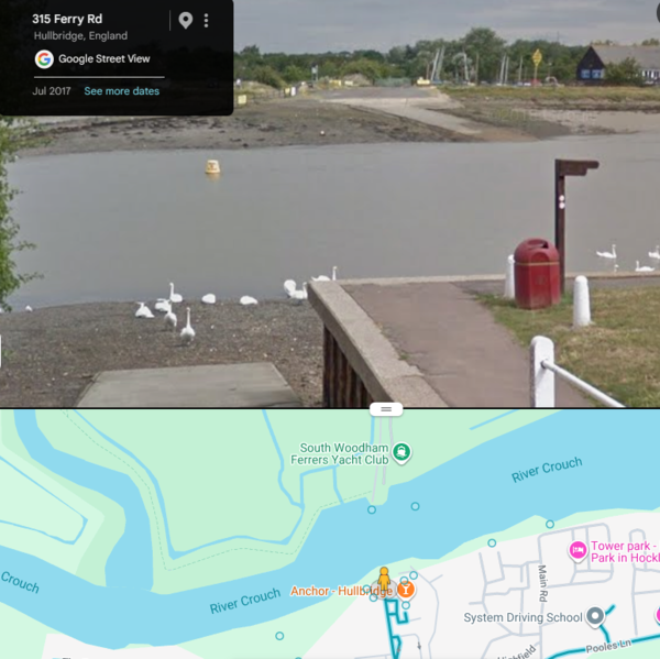
This journey is from a proposed ride in Essex. CycleTravel indicates an unpaved path crossing the river Crouch at South Woodham. But when I look with Google Street View this is what I see. My bike hasn't got water wings, so I had to re-route to Battlesbridge, two miles upriver. The street on the south side of the river is called Ferry Rd so there was once a ferry, but I don't think it still functions. Can someone modify OSM appropriately?
Here is a short part of my normal route to/from Winchester
https://cycle.travel/map/journey/151307
Travelling North-South the route is fine and exactly matches the situation on the ground. Now use the "reverse route" button. The route takes you on a hilly 3mile detour! In the real world there is no impediment in either direction, so I assume there is some wrongly-applied "one direction" message in OSM. It's really annoying because a lot of the many exercise rides we have ridden since lockdown go this way and I want to be able to choose freely which way round to plot. I have no experience of editing OSM and don't wish to make this error even worse by untutored meddling! Please help if you can.
I have just plotted a 256 mile route along the Mercian Way (mostly NCN 45). When I try to export as PDF it tells me the route is too long to export as a single PDF and asks me to split into chunks of less than 300km. Is there a way to do this without losing all my route tweaks or will I have to start again and plot it in two sections?
On a related topic, it would be nice to have more control over the scaling of PDF maps. I often have to do lots of fiddling with print magnification to get a usable printed map. Yes I know I ought to buy a Garmin, but I'm old-school and rather like paper maps ...


Made in the Cotswolds. Published by Éditions Système D Ltd.
Log in with your cycle.travel account:
| Password |
Or simply use your account on:
