


Today cycle.travel’s route-planner gets the biggest single improvement since it launched – a new feature we call Smart Turns.
cycle.travel now casts a forensic eye over every turn and junction on your route. Turns across busy roads get downrated; so does weaving from street to street in cities; so does any turn where you have to dismount. Routes with fewer turns are preferred, and safe crossings (e.g. ‘toucan’ crossings) get a bonus too.
The result is safer and simpler routes in both town and country. But, more than that, the turn-by-turn directions for each route are also clearer and more reliable.
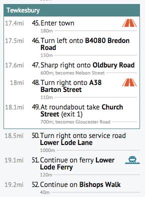
New instructions like ‘Cross major road’ and ‘Leave town’ help you navigate each step at a time. Two-stage turns, where the road flares past a central island, are shown as one clear instruction. So too are doglegs, where a left is followed immediately by a right. Plus there are new symbols to highlight unusual sections of route: unpaved trails, busy roads, ferries, and sections where you need to push.
We’ve also made it easier to follow long-distance cycle routes, such as EuroVelo or the National Cycle Network, without repeatedly dodging off-route and back on again.
But there’s more!
As well as this major new feature, we’ve made dozens of smaller improvements to cycle.travel’s route-finding. It’s now smarter about routing on unpaved tracks, particularly in mainland Europe. Roads with (legally) cyclable hard shoulders get a better rating. Cycle contraflows and other one-way systems are handled better.
We’ve made a concerted effort to improve OpenStreetMap’s minor road data in the rural US, so you can find a safe, enjoyable route without having to ride down an Interstate or other busy road.
Finally, we’ve added Croatia and Mexico to the route-planner. Mexico doesn’t yet have height data but we’re working on it!
Coming soon…
These improvements are partly laying the groundwork for two exciting new additions to cycle.travel this summer – watch this space.
As always, the foundation of cycle.travel’s route-planning is the wonderful OSRM project, and the data contributed to OpenStreetMap: big thanks to all the OSRM developers and OSM contributors for their hard work.


Comments
This is all fabulous. But how do I find the "key" for route maps? Sometimes the route is blue and sometimes red dots in blue circles and other times blue or red dots!! But can't find explanation about what these mean. Thanks for your help.
If you've not already found it, in the top right corner of the map (just below the search box), one of the links is "Key" which will give you the map info.
Hi
Just for interest, why does the routing sometimes ignore cycle routes? Attached is a small section of a France north-south I am planning. You can see the route takes a D road whilst bypassing the nearby cycle route.
In this case, it's because the cycle route in OpenStreetMap is marked as having a sand surface. Cycling through sand is no fun so cycle.travel chooses the tarmac road instead. I suspect this might be an error in the OSM data and that the surface isn't really sand!
That's probably it. Even the French would hesitate to surface a bike route in sand.
Is there a way to print the cues from "smart turns"? I can download pdf's of the map, but they don't contain the turn by turn cue sheet.
Re: "In this case, it's because the cycle route in OpenStreetMap is marked as having a sand surface."
It would be good if the routing prioritised cycle routes regardless of the (possibly incorrect) underlying data about the surface etc. Cycle routes are almost always the best way.
Re: "In this case, it's because the cycle route in OpenStreetMap is marked as having a sand surface."
It would be good if the routing prioritised cycle routes regardless of the (possibly incorrect) underlying data about the surface etc. Cycle routes are almost always the best way.
I disagree I'm afraid, I've seen some pretty awful cycle routes (including one through Thetford forest that you could have made sand castles on). I almost always reject them and stay on the road
II actually disagree that bike routes are always best. Having just done Toulouse-Bordeaux-St Malo, there were many days when I preferred to take a quiet road than stay on the more indirect bike route. The Velodyssee is great, but it utilises the local bike paths of towns, especially near resorts, and many of them are built on the "let's take tourists up this hill for a view" principle.
Be very circumspect about bike routes in France.
I live in France and I've learned the hard way that even European routes like La Loire à Vélo need to be processed on Cycle Travel - there's a part near Saumur, for instance where they take you up a 15% gradient because it takes you past a camp site... and don't talk about uneven surfaces on gravel or sand...
I always use the "Go Map!" app to update the raw Open Street Map data when I'm travelling, as others have said many cycle paths around the world leave a lot to be desired!
Right now, when I plan a GPS route, I do it so each day is a single leg going from the front door of my hotel to the front door of the next hotel. But that seems impossible as cycle.tour seems to only accept cities and towns and not street addresses. Am I right or is there a way to get around this problem? Many thanks.
Hi Bob – cycle.travel’s mapping is based on OpenStreetMap (the community-made map of the world). Although OSM has pretty much every street there is, it’s missing a lot of building/house numbers.
If you omit the house number – i.e. type “Market Street, Charlbury” rather than “7 Market Street, Charlbury” – it’ll usually find the right road. You can then drag the start/end point to the exact location once the route is planned!
It sounds really handy for planning multi-day bike trips. I've been thinking about cycling from Seoul down to Busan in South Korea and visiting some places along the way. Do you happen to know if cycle.travel's mapping covers South Korea at all? Being able to easily add accommodations and split the trip into stages would be really useful for planning a route there.I've been reading this article https://gowithguide.com/blog/tourism-in-south-korea-statistics-2023-all-you-need-to-know-5254 it mentioned some interesting spots between the cities like Seoul and Busan that I'd love to check out. This tool seems like it could help map it all out logistically.