

Nevers A country town at the confluence of the Loire and the Allier, Nevers is right on the edge of, but also capital of, the department of the Nièvre in the Burgundy region. The Palace of the Dukes of Nevers is a fine Renaissance château, and visits are free. The palace houses the city hall and also the tourist office as well as some exhibition rooms, an aquarium and displays about the city. The most stunning side of the Palace is the exterior, which is a fine example of Loire valley château architecture.
St Cyr & Ste. Juliette's Cathedral is a small gothic cathedral in the Burgundian style, which was bombed by the RAF in the second world war, and subsequently rebuilt.
Nevers is easily accessible by train from Paris Gare de Bercy. It can also be reached by train from Lyon, Tours, Orleans, Nantes and Dijon, among other French cities – and being on the EV6 Loire-Danube veloroute, it can be reached by cycle from as far away as Budapest and Nantes! From Paris, it can be reached by cycle via the EV3 which joins the EV6 at Briare.

Cuffy (14km) The V70 starts at Cuffy, a village just to the south of Nevers, where it branches off from the EV6 at the western end of the 320 metre Guétin aqueduct that carries the Canal Latéral à la Loire (and the EV6) across the Allier. Follow the cycleway signs for Apremont on the southwest side of the canal before turning sharp left to head south on a dedicated cycleway. This goes for 3km as far as the unusual – maybe unique – Écluse des Lorrains, a circular lock that once allowed sand boats to be pulled from the Allier into the canal system.
After this curiosity of the industrial age, the V70 follows the D45 road. The first village to be reached is Apremont sur Allier, one of the plus beaux villages de France. This medieval village has a Renaissance château and a superb parc floral, a 20th century flower garden inspired by the gardens at Sissinghurst in the UK.
Mornay sur Allier (31km) Carry on south on the D45, through the villages of Neuvy le Barrois and Mornay sur Allier. About a kilometre after Mornay, you leave the department of the Cher and enter the department of the Allier, where the D45 becomes the D101. You have now entered the Auvergne region through which you will cycle for another 400km.
The Via Allier winds slowly southwards on the left (eastern) side of the Allier, which is the quiet side – the main road (the N7) and the railway being over on the eastern side of the river. 45km after entering the Allier, it reaches the small city of Moulins, capital of the Allier department, with a fine historic centre.

Moulins (76km) The V70 skirts Moulins to the west, remaining on the left bank of the Allier. The historic city centre lies just across the river, and is reached by crossing the 18th century Pont Régemortes, still the only road bridge across the river in the city.
In spite of having 13 arches, this bridge has proved more resistant to Allier flood surges than a number of more recent bridges. Over 300m long, it provides a fine entrance to the old city. Moulins is a designated ‘Art and history’ town, and the historic centre between the cathedral and the town hall (hôtel de ville) offers a maze of narrow medieval streets, with many half-timbered houses and plenty of cafés and restaurants.
The cathedral is a fine example of late medieval Gothic architecture. It’s most famous for its renowned altarpiece known as the Moulins Triptych, painted in 1498 for Peter II Duke of Bourbon, by the Flemish artist Jean Hay – until recently known as the Master of Moulins. Just a short way north-east of the cathedral is the Anne de Beaujeu Museum of art and archaeology. Housed in the striking Renaissance wing of the former palace of the Dukes of Bourbon, it is noted for its collection of German and Dutch renaissance art, and 19th century French art. The Moulins tourist office website has more information.
Forêt de Moladier (85km) After Moulins, the V70 continues its route south and the landscape becomes gently undulating. After joining the D137 beyond the village of Bressolles, the route runs for almost 5km through the Forest of Prieurés-Moladier, a surviving part of the massive oak and hornbeam forests that once covered a large expanse of land to the west of the Allier.
After the villages of Besson and Bresnay, the V70 heads almost due south for 10km on the D 34 through typical ‘bocage’ countryside – fields, coppices and hedgerows. It could almost be like parts of rural England, though on a much bigger scale and with very little traffic on the rural byways.
Before reaching Verneuil, don't miss the left turn at a small crossroads in the middle of vast fields. Less than a kilometre after turning left, you'll see something new: the first vineyard. You are entering the wine-growing area of Saint Pourçain sur Sioule, Auvergne's largest wine area. After crossing the D2009 (the former N9), the V70 drops down into the Allier valley again before climbing back up onto slightly higher ground for the final kilometres into Saint Pourçain.

Saint-Pourçain (120km) Saint-Pourçain sur Sioule likes to brand itself the wine capital of Auvergne... or the most southerly of the Loire valley vineyards. 30 or 40 years ago it was maybe the best known wine from the Auvergne, having gained a VDQS (Vin délimité de qualité supérieure) label back in 1951, and its Appellation contrôlée label in 2009. The Saint Pourçain vineyard area is quite small, with 600 hectares of vines spread over a large area; but it's growing, and it's the only vineyard area you'll go through on this route. Local wines can be tasted on some estates, or at the Cave coopérative in Saint Pourçain (visits and tasting). Other than that there is little to see in Saint-Pourçain, which, with its 5000 inhabitants, is a typical small French town.
From Saint Pourçain, the V70 heads east then south through a bucolic landscape of fields and farms, eventually reaching the river Allier and crossing it at a village with the unlikely name of Billy. The small village is dominated by an impressive medieval fortress, dating from the 12th century. Guided visits are organised in the tourist season.
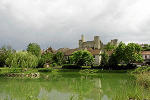
Saint Germain des Fossés (142km) Four kilometres south of Billy is the small town of Saint Germain des Fossés. Railway enthusiasts will want to stop off at the surprisingly grandiose station, with its great awning spanning five platforms. This fine structure dates from the days when Saint Germain des Fossés was a major railway hub, where the Paris to Clermont-Ferrand and Nîmes line crossed the Lyon to Bordeaux route.
Leaving Saint-Germain behind, the V70 runs close to the main Paris-Clermont railway line for the final 10km of this section into Vichy. At the entrance to Vichy, after crossing back onto the west bank of the Allier, the V70 runs through the extensive grounds of the national sports complex, past the golf course and horse-racing track (hippodrome), and along the banks of the great lake that divides Bellerive on the west bank from Vichy on the east.
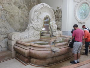
Vichy (153km) In 2021, Vichy acquired UNESCO World Heritage status, as one of the historic spa towns of Europe. To enter the heart of the town, cross the elegant Pont de Bellerive across the Allier, and you're there. If you turn right at the trarric lights after crossing the bridge, you'll find, 100 metres on, the Vichy Célestins spring, where you can replenish your water bottles for free with the naturally carbonated spring water to which Vichy owes its fame.
For many, though, the name Vichy is remembered as the seat of the puppet government of Maréchal Pétain, which ruled over the southern half of France during the Second World War. It is a memory that clings to the town, but one that it would rather forget. Indeed, Vichy was a popular spa town long before the Vichy Government set up in 1940, and it is for its mineral waters and its Belle Epoque ambiance that visitors come to Vichy in the 21st century. As a spa town, Vichy goes back many centuries; as an elegant place to stay and take the waters, it goes back to the late 18th century, blossoming like Cheltenham or Harrogate, its Regency counterparts in England.
The town was profoundly enhanced in the second half of the 19th century in the ‘English’ style, with the addition of landscaped parks and much eclectic Second Empire architecture. The Allier was dammed at the north end of the town, to create the famous plan d'eau or lake. During the Belle Époque period between the 1880s and the start of the Great War, Vichy was a fashionable resort. Monuments from this time include the Art Deco Opera House, completed in 1903; the famous wrought-iron covered walkway in the Parc des Sources, completed in 1900; and the 1902 Music Kiosk.
There is plenty to see in Vichy, including its small museums, thermal establishments, and attractive promenades along either side of the lake. Boats can be hired, and there is also a free passenger ferry that plies back and forth across the middle of the lake in the summer months. Find out more on the local tourist office website.
Limons (173km) South of Vichy you'll get the feeling that the mountains are closing in, but for the V70 there's still a good few kilometres of relatively easy cycling to go.
The River Allier runs along the eastern edge of a wide fertile plain known as La Limagne, at the other side of which you'll glimpse from time to time the first and most dramatic of Auvergne's volcanoes (dormant), the most impressive being the Puy de Dôme, rising to a height of over 1600 metres just to the west of Clermont-Ferrand. The Allier skirts the Clermont-Ferrand area well to the east, and the route south of Vichy remains generally close to the river for the next 60km.
Pont du Château (206km) The next small town to be reached after Vichy is Pont du Château, which has an interesting Romanesque church where the polychrome medieval decoration of the nave was re-created in 1994.
Just south of Pont du Château, the V70 crosses the Allier on an old single-track girder bridge, before turning away from the river and into the hills – giving a wide berth to the southwestern suburban sprawl of Clermont Ferrand and its inevitable traffic. The V70 has to leave the Allier valley here, as the first Allier gorge is coming up, and and the only road through it is the autoroute.
Vic le Comte (230km) 23km after Pont du Château is the town of Vic le Comte, famous for its 16th century Sainte Chapelle. This was built on the model of the Paris Sainte Chapelle for the marriage of Anne de la Tour d'Auvergne to John Stuart, Regent of Scotland and Duke of Albany. The Sainte Chapelle is among the finest Renaissance buildings in Auvergne, and has some stunning stained glass windows.
From Vic le Comte to Orbeil, on the outskirts of Issoire, is another 15km, taking in the V70's first col, the Col de la Croix des Gardes. At 654 metres, it's not one of France's great cycling challenges, but it's over 200m higher than the Allier as it winds through its most northerly gorge. Orbeil is 5km from the centre of Issoire, and there are a number of budget hotels close to the motorway intersection.
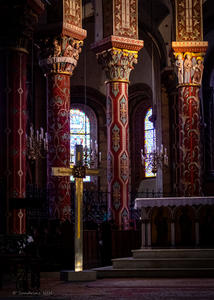
Issoire (244km) Issoire is a very attractive small town, huddled round the abbey church of St Austremoine, one of the finest medieval Romanesque churches in the Auvergne.
Built in the 11th and 12th centuries, the church is most famous for its richly decorated 13th century interior, which was extensively renovated and in part reinvented in the mid-19th century. While some of the artwork is of 19th-century Gothic revival inspiration, the interior gives a rare insight into how many medieval churches were at the time highly decorated and colourful. The various restorations of the church have been extensive. Even the two towers, which look very medieval, were in fact added in the 19th century, as was the southern facade. (Read more about the town’s attractions on their tourist office website.)
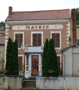
Auzat la Combelle (266km) The southern half of the V70, southwards from Issoire, is the more interesting, running through varied and dramatic landscapes as it leaves the Puy-de-Dôme department and crosses the Haute-Loire.
Brassac les Mines has an interesting small mining museum, with a replica coalface, but the opening times are very limited. After Brassac and Sainte Florine, two very small industrial towns, the V70 enters the Haute-Loire – and the Haut-Allier, one of the fourteen original ‘art and history’ areas in France, through which it will follow the Allier river for the next 70km.
The first noteworthy site is the medieval village of Auzon, a mile to the east of the V70. The historic village, with its Romanesque collegiate church with medieval frescoes, and its steep cobbled streets, stands on a rocky promontory at the foot of a narrow valley. After Auzon, it is another 15km of mostly flat cycling to reach the small town of Brioude, famed as one of the most interesting and attractive small towns in France.
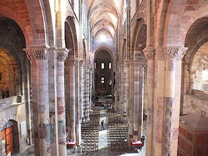
Brioude (292km) A small town of 7000 inhabitants, Brioude is the jewel in the crown on the Via Allier.
The town's historic centre is built around the magnificent St Julien's Basilica, a cathedral-sized Romanesque church which is one of just 260 sites and monuments in France to have been awarded the prestigious three-star rating by the Michelin Green Guide. Unlike the abbey in Issoire, St Julien's Basilica was never renovated or rebuilt in the 19th century, so the building that stands today is essentially over 800 years old. It contains some remarkable 13th century frescoes, fine medieval sculptures, and a unique late medieval mosaic floor. Of particular interest both from the inside and the outside is the 12th century apse, with its five chapels and remarkable polychrome stone decoration. The basilica has always been a site of pilgrimage for the relics of Saint Julien, who was martyred nearby.
The cobbled streets around the basilica are home to cafés, restaurants and arts and crafts shops. There is also a lace-making museum and, just outside the town centre, a freshwater aquarium. In the summer months, the Doyenné arts centre, a stone's throw from the basilica, hosts a major art exhibition (recent exhibitions have featured Chagall and Miro) - open July to October. There are also other art exhibitions, including the Watercolour Biennial (odd-numbered years) in July and the Painting Days (Décades de la peinture) in August. Find out what’s on at the local tourist office website.
The first stop after Brioude has to be the dramatically sited village of Vieille Brioude, standing at the entrance to the heart of the Haut Allier. Before crossing the fine stone bridge with its 45m span, visit the small Romanesque church and next to it the wine-growing museum. Though today there are just a few small vineyards to be seen here and there, this valley was once an important wine-growing area.

Saint Ilpize (305km) The V70 now follows the quiet D16 road up the east bank of the Allier, through fields, woods and small villages, as far as Saint Ilpize. The medieval château of Saint Ilpize is a kilometre (and a short climb) off the route. Perched on a volcanic outcrop and open all hours, it offers a birds-eye view down onto the roofs of Villeneuve-d’Allier on the other bank.
On the way down from the chateau, stop and look at the historic vineyard with its information board, before returning to the V70 to cross the Allier once again – this time on a historic suspension bridge high above the water below. Technically it's a cable-stay bridge, built in the mid-19th century by an architect who had been inspired by the new Brooklyn Bridge in New York.
Two kilometres after Villeneuve d'Allier, in the direction of Lavoûte-Chilhac, there is another show vineyard on the right of the road as you pass the village of Auzat. To learn all about wine growing in this area, take the discovery trail round the vineyard with information in English too. Before the village of Laboue, note the basaltic ‘organ rocks’ at the side of the road. Don't stop for photos yet, as there are far more interesting organ rocks to come as you continue through this volcanic landscape.

Lavoûte Chilhac (314km) The next gem is the small town of Lavoûte Chilhac, where for the third time you will cross the Allier on a historic bridge. The bridge at Lavoûte is a large 15th-century, three-arched, hump-backed stone bridge with a span of 45m. Beyond it is the historic centre, on a rocky peninsula in a 180° loop in the river; the 16th century Cluniac Benedictine abbey is free to visit, plus there’s a cluster of cafés, a kayak hire outlet, and a tourist office.
The V70 does not cross the bridge, but continues along the D585 on the west bank. Immediately after Lavoûte Chilhac is the village of Saint-Cirgues, whose church is well worth a visit on account of its magnificent 15th century frescoes which are in remarkably good condition. Three kilometres after Saint-Cirgues, the V70 turns left onto a very small road that cuts across the fields in the direction of the next small town, Chilhac; and this being the Haut Allier, you enter it across yet another historic bridge, this time a real suspension bridge. Before crossing, have your cameras ready to photograph the massive cliff face opposite with, at the top of it, the historic centre of Chilhac.
As you climb up to Chilhac, you'll see the first really impressive set of basaltic organ rocks, relics of the volcanic activity that formed the landscape in this area. Note also in places beside the road the wild cactus plants, small prickly pears, that are among the botanic quirks of the Haut Allier. Chilhac is a small historic village with a café-restaurant and a shop and not much else except a very interesting paleontological museum, showing some of the prehistoric remains and artifacts that have been discovered in the area.
Carrying on after Chilhac, stop to admire, as you pass below it, the remarkable Falaises de Blot (the Blot cliff face) with its extensive array of organ rocks. As you pass, think of the history, as shelters at the foot of the cliff have revealed some the very oldest signs of human habitation in Europe. Just after Blot, beside the village of Le Chambon, you again cross the Allier... though not this time on a historic bridge, to rejoin the D585 for the final 6km to Langeac. (More information about the Gorges de l'Allier at the local tourist office website.)
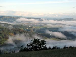
Langeac (331km) Langeac, capital of the High Allier gorge area, is a small town with a compact historic centre. The Saint-Gal collegiate church is a medieval Gothic church with plenty of charm, located on a picturesque square with a café and a brasserie serving local and organic produce. You'll need to take on energy at Langeac, as from now on the climbing begins.
The V70 continues southwards for 5km on the D585, rising out of the valley and then back down into it for the picturesque village of Chanteuges. The main attraction of Chanteuges is its Romanesque abbey church and ancient monastery (with cloisters), perched on a rocky plateau between the village and the Allier. The climb up to the abbey is worth it, and can be done on two wheels or – by a shorter route – on two feet.
Just 2km after Chanteuges, after the V70 leaves the D585, is Saint-Arcons, another very picturesque village. Perched on a rocky outcrop, this historic village was largely renovated in the 1990s from a cluster of tumbledown cottages to be made into a dispersed luxury hotel which sadly went out of business after 2007.
Prades (344km) From Saint-Arcons it is another 7km beside the Allier to the village of Prades, Shortly before Prades you'll cycle right beside the curious 13th century Romanesque chapel of Sainte-Marie-des-Chazes, once part of a monastery on one of the Compostela pilgrimage trails that pass through this area.
At 550m above sea level, Prades is the start of the real climb up out of the Allier gorge towards Saint Privat d'Allier at 900 metres, some 20km further on. Before leaving, you cannot fail to see the remarkable Prades cliffs, the most impressive set of basalt organ rocks in the area. After that, there's a 3km climb out of the Allier gorge on the D48, until it reaches the fields and pastures of the high land. At the hamlet of Vergues, turn right onto the D301.
From now on, cycling the V70 is all about fabulous views. The trail follows a spectacular corniche route, remaining at altitudes between 700m and 900m with panoramic views down into the gorge and to the mountains beyond.
Saint Privat (361km) At Saint Privat d'Allier, a large village with a medieval church, the V70 crosses the Via Podonensis, the now highly popular long-distance hiking trail from Le Puy to Santiago de Compostela. We continue on the corniche route, now the D40, before dropping gently down along wooded slopes to meet up with the Allier river at Alleyras, around 660m altitude. (Cyclists who are put off by climbs can avoid the stretch from Langeac to Alleyras by taking the spectacular train ride through the Allier Gorge – but check train times at the station in Langeac, as there are only a couple of trains a day.)
After Alleyras, the V70 continues south on the D40 and D31 to Saint-Haon, then back down to join the Allier again at Chapeauroux. Much of this part of the route offers spectacular views to the south and the west, with some dramatic steep volcanic rock formations around Le Nouveau Monde. After Chapeauroux, which lies at 740 m, the V 70 follows the D88 through some impressive rocky terrain, as it climbs for 8km to reach an altitude of 1000m near Jagonzac.
Summit (403km) From here, the trail remains at or around 1000m as it follows the D40 for the next 14 km as far as Pradelles – the highest village on the route at an altitude of 1100m. This is high plateau country, a French Altiplano, with sweeping views in all directions. In early summer, the fields are full of wild mountain flowers: narcissi, marguerites, scabius, daffodils and many more.
Pradelles is a historic mountain village, and classed as one of the plus beaux villages de France. For those who want to stop and enjoy the mountain air, there is a vélorail trail, 15km of old railway line now revived for use by pedal-powered carts. The railway being single-track, there are strict time periods for outward and return journeys.
From Pradelles, it is just a gentle 6km drop down through fields and woods to the end of the Haute-Loire department and the small town of Langogne.
Langogne (425km) This is not quite the end of the Via Allier, but it is the end of the trail down through the Auvergne.
From Langogne (of which more on the local tourism website), the V70 continues south for 5km on the D106, after which it is no longer marked. Cyclists can however continue their southward route on the D106, past La-Bastide-Saint-Laurent and on to the Col de Thort, at 1120m, before the start of a long gentle drop down towards the Mediterranean plains. Alternative options from Langogne include putting the bike on the train southwards to Nimes, or back northwards to Clermont-Ferrand. Alternatively, cycle westwards to Mende, where one can pick up the V86, then the EV3, for a long run down to the southwest Atlantic coast of France at Biarritz… or across the Pyrenees and on into Spain!
Log in with your cycle.travel account:
| Password |
Or simply use your account on: