
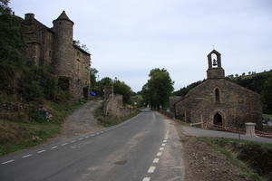
Mont Lozère Our downhill journey starts at the Col de Finiels, a lonely peak in the heart of the Cévennes. The area was popularised among English-speakers by Robert Louis Stevenson and his Travels with a Donkey. Mont Lozère, the source of the Tarn and the highest point on the Robert Louis Stevenson Trail, is just a short way to the west albeit not on a cyclable trail; you’ll cross the trail by a ski station a few kilometres into the ride. Here, the scrub of the higher slopes gives way to lusher woodland of the sort that will characterise much of the route.
At the sleepy village of Le Bleymard we cross the Lot for the first time, an easily missed stripling of a stream slowly gathering in the headwaters from the Cévennes. The D901 faithfully follows the twists and turns of the Lot downstream from here, at one point ducking into a tunnel to cut out a particularly extravagant meander.
Bagnols les Bains (19km) At the little spa town of Bagnols les Bains, you have a choice that will present itself again and again throughout this tour. The official cycle route heads uphill on quiet, scenic, but steep lanes. Or you can continue along the valley road, missing most of the climbing and enjoying views of the Lot, but rubbing shoulders with fast car traffic. Our guide follows the hillier quiet routes, but the choice is yours.
In this case, it’s a steady 5% climb from Bagnols to the Col de la Loubière, then a long fast descent through wooded hillsides to Lanuéjols. (It’s about the same gradient, but feels more!) At Rouffiac, the foot of the climb, you can either follow gravel tracks (sometimes very steep) through woodland – or perhaps more realistically, take the main road to Balsièges then climb for 4km on the D986 before equilibrium is restored on the peaceful, mostly flat D31.
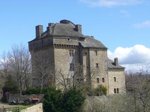
Chanac (58km) If your visit is lucky enough to coincide with one of the few times the Château de Chanac is open to the public, do take the opportunity to climb it (on foot!) for amazing views of the Lot valley. In any case, this pretty village is a handy stop with a boulangerie, campsite, and a few restaurants and hotels.
From here, the route gets up close and personal with the Lot, tiny roads and gravel tracks so close to the banks they could almost be a towpath. Sadly – after a short, sharp climb to the valley-side village of Le Villard – this doesn’t last forever. At Les Salelles (with its tiny SNCF station), you can either take another hilly excursion via Auxillac and Banassac, or venture onto the main roads.
In the absence of any signposting, we’d suggest gritting your teeth and going for the main roads. The N88, though deeply unpleasant, only has to be endured for 2km. Most traffic then leaves for the A75 autoroute, leaving the old Lot valley road for the cyclist, the occasional day-tripper, and the inevitable smallholder in a little Citroën van. After all, no satnav would choose so extravagantly looping a road, but that’s what makes this stretch so enjoyable – that, plus the steady descent all the way to Saint Laurent d'Olt.

Saint Laurent d'Olt (89km) The Olt (or Oltis) is the ancient name of the River Lot (what can we say? River names are weird), and the villages in this part of the valley have kept the old name. Saint Laurent d’Olt is the first such, perched on a high outcrop above a meander of the river.
It’s here that the cycle route signs finally appear, directing you not into the village, but up onto an absolutely tiny road following the northern valley side. Yes, it does involve a little climbing at first, a slow ascent to the hillside hamlet of Falguières. But this practically traffic-free road is undoubtedly worth it. The woodlands part here and there to give dramatic views down to the river below until, below the medieval castle village of Pomayrols, the road plunges down to the valley floor. From here it becomes towpath-like once again, shadowing the river’s south bank by just a few metres.
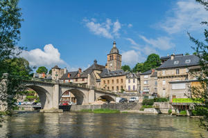
Saint Geniez d'Olt (108km) You may have been wondering where the tourists are in this, the famous Lot Valley. Here they are at Saint Geniez, a justly popular town full of pavement cafés, a riverside promenade, campsites and hotels. Remarkably, it’s none the worse for this, and coasting through on a bike is quite the best way to see it. The route stays on the south bank, but do ride across the bridge (and back again) if only to visit the impressive church.
After Saint Eulalie d'Olt comes a challenging 7km climb away from the river. Lassouts, in the first stages of the descent, has a very welcome café to catch your breath. Far below, the Lot is dammed to create a reservoir, though sadly it’s barely visible from the cycle route.
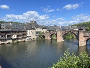
Espalion (135km) Espalion is an endearing town, just the right balance between a busy centre for locals (don’t miss the Friday market) and a tourist-friendly hub with some very decent restaurants. Do, however, ignore the signs on the way out of town that take you along a rather rocky and unnecessarily steep set of riverside paths, and just follow the D556 west instead. What might seem an annoying dogleg towards Bessuéjouls is worth it for the 10th century church of St Peter, with its unusual first-floor chapel.
Estaing is, quite rightly, one of the Plus Beaux Villages de France, its high stone buildings enclosing narrow streets nestled in a cleft in the hillside. The route stays on the south bank, but again, do ride over the medieval pilgrims’ bridge for a look – taking care not to mow down any weary backpackers on their way to Santiago de Compostela.
Here the choice of cycling the Lot Valley rears its head again. You can continue to follow the signposted cycle route, which hugs the valley side for 5km before climbing sharply – a 4km ascent at an average of 9%, complete with hairpins. Or you can follow the main road, where there’s barely a centimetre of climbing and where the views of the Lot remain delightful, but at the cost of dealing with traffic. Our experience is that the main road is not that bad, and at 10 miles (16km) it’s easily polished off in less than an hour. But if you do want to tackle the climb, you’ll be rewarded with a plateau of little farm roads, encouragement from the Camino pilgrims you meet, and a glorious descent down to Entraygues.
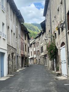
Entraygues sur Truyère (171km) The confluence of the Lot and the Truyère, Entraygues is a handy little town with cafés, a small supermarket, and a lovely spot by the riverbank where you can relax after the climbs of the last stage. It’s not in the slightest bit touristy, but the narrow streets, timber-framed houses and riverside castle are enjoyable to poke around.
From here, the riding couldn’t be any easier. A quiet D road, almost entirely devoid of traffic, follows the twisty wooded valley downstream. The delightfully pretty villages of Vieillevie and Saint Parthem are the only interruptions to this thoroughly enjoyable scenic ride, which continues all the way to the river bridge at Agrès. Fortified by the Truyère and the streams rushing down the steep valley sides, the Lot is by now much wider. It’s here at Port d’Agrès that the river formally becomes navigable. Restoration of the navigation is still incomplete and likely to remain so for several years, but as you head downstream, you’ll start to see occasional boats and all the navigation paraphernalia of locks and quays.
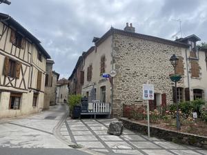
Flagnac (209km) At the end of July, the little village of Flagnac comes alive for ‘Hier un village’, a son et lumière spectacle telling the story of rural life at the start of the 20th century. 250 actors and 500 locals take part in the production which draws visitors from around France. The rest of the year, Flagnac is just a plain old gorgeous village with a handy supermarket on the way out – and a brief opportunity to exercise your climbing legs. An alternative braid of the route on the north bank takes in the equally attractive village of Livinhac le Haut, centred on a classic market square with church and traditional bistrot. The pillars of an abandoned bridge have been restored as riverside viewpoints: cross to the Livinhac bank to visit the boulangerie just by the river, and enjoy your morning pastry with a fine view of the Lot.
With most of the climbs over (but not quite!), the route takes on the style of a traditional French véloroute, piecing together short sections of cycleway and quiet lane. The route takes you past several locks, restored to navigation but seemingly unused: at Bouillac, the lock-keepers’ cottage appears to be inhabited by a whole family of feral cats. (There’s a children’s book in there somewhere…)
Once again, you have the choice of a climb or a busy road here. We’d suggest continuing along the signposted route, which climbs at 5% to Asprières before descending into the narrow valley of the Diège: the main scenic interest here are the impressive railway arches carrying an implausibly rural line. Alternatively, the D 840 along the river valley to Capdenac is busy but easy riding.
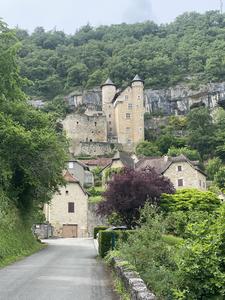
Capdenac (241km) Capdenac is two settlements, separated by the river, and both just off the signposted route. The original Capdenac (‘le haut’), on the north bank, is another of Les Plus Beaux Villages de France. Perched on a high outcrop overlooking a wild meander of the Lot, its medieval castle, clifftop viewpoints and impossibly narrow passages make it a worthwhile visit. But not, we’d suggest, on a loaded bike – lock it at the bottom and walk up the track from Les Peyrières. 80 Jewish children were sheltered in the convent here during the Second World War.
On the south bank, Capdenac-Gare sprang up around an important railway junction. It feels rather down-at-heel in comparison, but has some decent enough places to eat, a hotel near the river bridge, and a co-operative bike workshop.
Back on the route, a few little bumps in the road lead to more easy riverside cycling. Crossing back onto the north bank after Balaguier d’Olt, the two Toirac villages are prime sightseeing. To the right, Saint Pierre Toirac’s church dates to the 12th century; turning left, the similarly antique Château de Larroque-Toirac hangs from the valley side and is open for guided tours through the summer months.
You’ll also see a railway here, tracks still in situ but very much derelict. This is the former line along the valley from Capdenac to Cahors and Fumel, closed to passengers in 1980. A tourist service continued until 2003, when the railway authorities demanded expensive repairs beyond the volunteers’ budget. Twenty years on, it’s gradually being converted into a cycle route, though not yet here. Look out for the tunnels and viaducts which will one day make this a fabulous family-friendly ride.
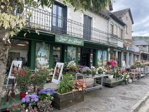
Cajarc (269km) Cajarc hides its secrets well. At first glance it’s just – just! – an elegant town of brasseries, florists, bars and restaurants, all arranged in a tree-lined loop. Step within the loop, though, and the wide boulevard gives way to a maze of narrow medieval streets with a 12th century church at their heart. The suspension bridge south of the town isn’t on the cycle route, but take a look anyway; this is a regular crossing point for Camino pilgrims. While you pass, peek along the former railway line to see an abandoned vintage train parked up at the old station.
The flailing meanders of the river give this next section of route surprising variety. One moment you’re riding across flat farmland formed by a loop in the river, the next you’re unexpectedly climbing as the road has nowhere else to go. Then, at Calvignac, the road finds a narrow space at the foot of the cliff with the village perched some 50m above. Approaching Cénevières, the old railway somehow manages to squeeze into the little space available, before heading to the other bank across an elegant bridge – one day, hopefully, to become a cycleway.
Finally, at the next bridge, we leave the river to turn up a steep 1.5km climb. But there’s a good reason for it, and that reason is…
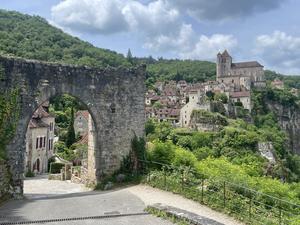
Saint Cirq Lapopie (291km) Saint Cirq Lapopie is, without doubt, the scenic highlight of the Lot. Voted France’s favourite village, it might also be its hilliest – high above the river with commanding views, yet itself set at several levels with steep paths between them. It’s undeniably touristy, with cafés, ice-cream stands and artisan perfume shops everywhere, but still magnificently scenic. It’s worth every metre of the climb.
The signposted route continues on quiet back roads away from the river, with a little more climbing before the descent begins. We think the best route, however, is to descend from Saint Cirq to the bridge at Bouziés. Although the D 662 on the north bank has a little traffic, the scenery is exceptional. Rock cliffs loom above, and on occasion, the road goes into short tunnels just a few metres from the river. The old railway flits in and out, boats slowly cruise up and down the river, and there are campsites, boulangeries and pleasant villages. It’s too good a length to miss.
(There’s a third option: descend immediately to the riverbank via the Chemin des Lezes, then follow the tiny road along the river. This becomes the old towpath, or chemin de halage, where you have no choice but to push – because it’s a narrow, low pathway dug into the rockface. It’s been photographed a million times, so why not make it a million and one?)
At Vers a busy road joins from the north, but we can cross over onto the south bank here following the Vagabonde V87 cycle route, a winding, undulating road with high rock sides and fine views. This rejoins the official route at the small village of Arcambal.
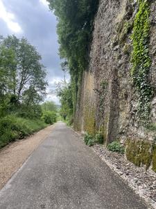
Arcambal (310km) At last! The abandoned railway that has taunted us for the last 70km becomes a cycleway here. It’s a fine example of the genre, with sturdy stone walls that would once have been blackened with smoke from passing trains.
This length was fully opened in 2025, the latest in the ambitious project to build a full voie verte along the Lot valley. In 2026, a route should open to the west of Cahors too. For now, enjoy this family-friendly, traffic-free – and, crucially, flat route.
Although the signposted route stays on the far bank, it would be a shame to miss the historic centre of Cahors. Cross on the busy main bridge and make your way into the old town, which is in the south-eastern quadrant of the peninsula. The highlight is the cathedral of Saint Etienne, but if you’re passing on a Wednesday or Saturday morning, do browse the magnificent market that sprawls from the Place Jean-Jacques Chapou down the Rue Nationale. This is a city of tall, medieval buildings lining narrow streets. As a result, most are one-way traffic, which makes exploring by bike rather frustrating. Lock your bike up instead and wander around by foot.
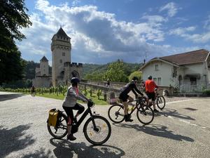
Cahors (320km) Cahors’ most photographed landmark is the 14th century Pont Valentré, a Unesco World Heritage Site. This three-towered bridge over the Lot is closed to cars, and though bikes are permitted, the cobbled surface makes pushing more appealing.
On the far bank we rejoin the signposted route for an uninteresting trudge through Cahors’ suburbs and light industry. Normal service is restored at Pradines, where a tiny road takes you right to the banks of the Lot; it might seem an unnecessary diversion from the direct route, but the fine views over to the Château de Mercuès are worth it. The moderately busy D 8 then retreats from the riverside until Douelle.
All of this is very much a temporary route: a brand new cycleway is being constructed on the north bank from Cahors to Mercuès, from where the old railway has already become a voie verte. It’s expected to open in 2026-27. We pick up the route at Douelle’s railway bridge, from where it’s traffic-free cycleway (almost) all the way to Luzech.
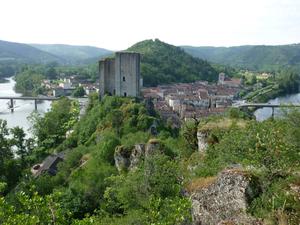
Luzech (342km) If you’re one of those cyclists who religiously follows every twist and turn of a signposted bike route, Luzech will test your resolve. At its narrowest, the peninsula is just 200m wide here – but the official route departs for a 4km tour along the meandering Lot, through vineyards on the appropriately named Route de l’Île. Luzech is a headache for those restoring the River Lot to navigation, with a sizeable hydroelectric dam blocking boat passage.
Just downstream is the railway bridge which immediately dives into a tunnel through the peninsula. This part of the railway hasn’t yet been reclaimed, so it’s back onto a succession of D roads, a little less busy here. This is quite the loopiest section of river, with repeated meanders enclosing yet more vineyards. Fortunately, there are several villages where you can sample the local wines.
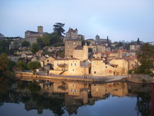
Puy l'Evêque (375km) The village of Puy l’Evêque, the local capital of wine tourism, is an opportunity to both work up and fulfil your thirst. It’s a sharp climb up from the river to the village square, with the slowly curling Grand Rue going some way to even out the gradient. The medieval streets around Rue de la Cale are the most photogenic part of town, while Grand Rue is where you’ll find the wine sellers. There are fine viewpoints back over the Lot, and conversely from the banks of the Lot up to the village.
We’re back on the railway from here; an enjoyable stretch of voie verte crosses the Lot before squeezing onto the narrow banks below the busy D 811. After a brief stretch on tiny roads that are practically traffic-free, the railway path takes us through the sprawling village of Fumel, notable mostly for some unexpectedly fine churches. The hitherto rural Lot is interrupted here by some unexpected riverside industry, while an ingenious solution has been found to the barrage that until recently obstructed boat passage – a transbordeur or boat transporter, where boats are lifted into a cradle and driven a short distance past the dam before being launched back into the water.
An operational railway has reclaimed the trackbed from here, so there’s no more voie verte for a while. Instead, tiny roads with occasional views of the river take a gentle course through farmland – mostly flat, though with an unexpected climb halfway to Saint Sylvestre. Look out for plum trees – prunes are an unexpected local speciality!
Saint Sylvestre sur Lot is a workaday village with useful facilities (boulangerie, supermarket etc.), after which the route departs from the river for a back-roads journey through vineyards to Villeneuve.
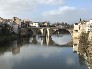
Villeneuve sur Lot (429km) The largest town on the route since Cahors, Villeneuve sur Lot is just as interesting and attractive. In fact, its 13th century bridge, the Pont des Cieutats, pre-dates the Pont Valentré in Cahors by a few years, though unfortunately the towers haven’t survived. The town spans both sides of the river, but the main draw is the old quarter on the north bank. Its charm comes from an eclectic mix of architectural styles rather than any one particular period: half-timbered buildings, arched passages, and a striking redbrick church, less than 100 years old.
Lucky Villeneuve also has not one but two voie vertes on former railway lines. We take the one that crosses the Lot on a narrow metal bridge towards Cassenueil, from where single-track lanes shadow the banks of the Lot closely. The wide river is appreciated by boaters, canoeists and picnickers alike, and every village is justly proud of its river frontage. This is easy, picturesque cycling, mostly untroubled by motor traffic, and well signposted throughout.
On the outskirts of Clairac the route forks. One branch heads off to Tonneins and a connection to the Canal des 2 mers à Velo cycle route, the towpath route from the Atlantic to the Mediterranean. But to say you’ve done the Lot, follow the slightly buesier D 271 towards Aigullon.
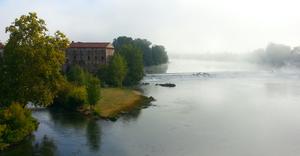
Aiguillon (478km) This is where the Lot flows into the Garonne, on its way to the Atlantic by Bordeaux. The (signposted) end of the road is the impressive lock and weir just above the road bridge, a fascinating complex of mill buildings and navigation works, though sadly not one that sees much river traffic. Carry on over the bridge to Aiguillon itself, a busy little town with a smart central square dominated by its mairie. There’s a railway station here for your return travels.
Log in with your cycle.travel account:
| Password |
Or simply use your account on: