
Become a supporter
On most topographic maps*, the shade used to reinforce relief assumes a light source at the North West (OpenCycleMap and OpenTopoMap are examples). Reality is otherwise, but this somehow is natural to the brain, and it gives a good impression of the actual landscape.
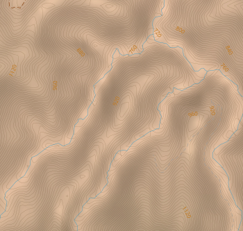
On cycle.travel however, the shade seems to only depend on the norm of the elevation gradient, i.e. the steepness of the slope. This results in pictures such as the one below, where valleys and ridges are hard to distinguish on first sight.
Would it be possible to modify the shading formula so that it gives better/more standard results?
*at least in the northern hemisphere.
I just noticed that the coverage was extended in Europe towards the East, with Slovakia and Hungary (at least), so I would like to say thanks!


Made in the Cotswolds. Published by Éditions Système D Ltd.
Log in with your cycle.travel account:
| Password |
Or simply use your account on:
