
Become a supporter
I'm curious how the cities in the turn by turn itinerary appear. Let's use this one here!
https://cycle.travel/map/journey/1013051
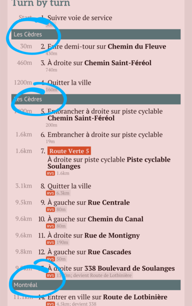
We see that Les Cèdres appears twice, and then it shows us Montreal even though we enter Vaudreuil... but not really, since we crossed the municipal border into Vaudreuil a few km earlier. The turn by turn shows us we're in Montreal until we kind of enter L'Assomption, skipping the mention of many other cities on the way.
I know the data comes from OSM, but is there any way one can correct that in OSM so that the cities can show properly?
Thank you!
See screenshot:
A simple feature request:
A search bar to look through forum posts, which would avoid duplicate posts and make it easier to find the answers yourself.
Hi,
This is relating a bug when viewing the elevation profile on the website. Let's take this previously done journey as an example: https://cycle.travel/map/journey/153632.
When looking at the elevation profile, on day 5, leaving quaint Frelighsburg, you notice there's a huge climb, perfect to showcase the bug in question. Point the mouse cursor to where the beginning of day (on the elevation profile) crosses the actual elevation at that point. You have the tooltip (popup) that shows an elevation of around 105 m, depending where exactly you point. Now, carefully move the cursor up and the tooltip will show a higher elevation, without even moving the cursor on the X-axis. It will show the elevation of where the cursor is at, regardless where the actual route passes.
That said, I realized you can't make the tooltip give you a lower reading if you bring the cursor down on the Y-axis below the actual route. So at least there's a way to confirm the elevation. Still, it would be nice if the reading didn't change as long as you stayed on the same Y-axis. I know this is probably a really complicated thing to code! Let me know if you need more information.
Thank you again for making such a great website!
Hi,
I read somewhere that the routing gets updated within weeks of updates being done on the map. There's a trail segment in Quebec (https://www.openstreetmap.org/way/384575735/history) that was damaged (that is, one of the tags got removed - the trail itself didn't get damaged), but I repaired it 4 months ago by putting the highway:cycleway tag back on it.
On this saved itinerary (https://cycle.travel/map/journey/620147), it is routed correctly, but that's because I created this route from a copy of another one, saved years ago. If I try to change the routing on that trail segment, I'd lose the correct routing and won't be able to bring it back.
I therefore can't route through it using cycle.travel. I was wondering if that was normal.
I have a routing question. There's a bridge in Montreal which is tagged as primary_link which c.t refuses to follow. Normally, that makes sense, but it's being temporarily used as a cycle bridge since the adjacent one is closed. It's been 9 months since the tagging has been changed on OSM. Here are the tags.
bicycle=yes
bridge=yes
bus=no
fixme=Accès de 06h00 à 23h00 tous les jours de la semaine. Réf.: https://shorturl.at/dmzRS
foot=yes
hgv=no
highway=primary_link
horse=no
lanes=2
layer=1
lcn=yes
lit=yes
maxspeed=20
maxspeed:advisory=20
motor_vehicle=no
note=temporary passage for pedestrian and cyclists until the cyclepath bridge is repaired
oneway=reversible
oneway:conditional=-1 @ (Mo-Fr 06:00-09:00)
shoulder=no
sidewalk=no
surface=metal
tourist_bus=no
truck=no
https://www.openstreetmap.org/way/652103133
I was wondering if there was a problem with the routing engine or if I could change a tag on OSM.


Made in the Cotswolds. Published by Éditions Système D Ltd.
Log in with your cycle.travel account:
| Password |
Or simply use your account on:
