
Become a supporter
Hello,
I am using c.t for planning routes in France, and switching between c.t. map and IGN classic has always been very useful. Since last trip (last week, via Rhona, from Geneva to Pérouges), the IGN maps are not displaying at all (white backgroung, both classic and digital). All other maps are. I am still connected, I tried restarting the app, and there is no pending update ... It works on the laptop, but I avoid caring it on a trip...
Thank you for your help and this wonderful app!
Cécile
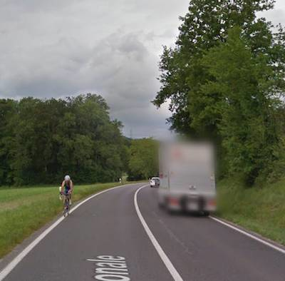
Hello, I wonder if there is a way (in OSM?) to document roads that are not "primary" according to definition (not connecting major cities), but very busy with lots of trucs and quite narrow, hence very unpleasant to bike on (to say the least). Screenshot from google street view.
Thanks!
Cécile
Hello!
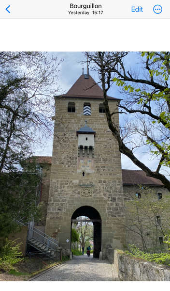
Yesterday I completed a nice ride from Bern to Fribourg, and realized that cycle.travel has a very strong aversion to a small section (c.a. 30m long), so that it will propose a detour of 4km, 100m climbing instead. I cannot figure out *why*, and if there is anything that can be improved on openstreetmap to help cycle.travel accept that small route (which is a very nice way to enter fribour, away from main traffic, through a historical gate and with a stunning view on the city...).
Can anybody help in identifiying the issue ? I tried to mark the roads and paths as access:cycle=yes and the gate as open, maybe this will then help?
Thank you!, Cécile
https://cycle.travel/map/journey/564911
A month ago, I did a bike tour usind CT for planning and was really stunned by how good the proposed route was! We just faced one challenge: a forest route that started nicely but was closed by a barrier and showed clear "no entrance" signs. As this was not documented on OSM, there would have been no way C.T would know of this. Therefore, I edited OSM changing the type of the road to "private" and adding the barriers.
Now that the OSM updates are take over in C.T, I tried to see if I would be directed through a different way, but C.T still wants me to take the "private" section and cross the closed barriers
https://cycle.travel/map/journey/501019
the closed section is between km 5 and 7, and there are barriers at the crossing with D469, which are visible on C.T map
As I continue editing OSM around my place, and still do not see effects on c.t, I was wondering if there is a simple way for me (besides asking;-) ) to know when did the last map update occur. This would help me deciding if I just need to be patient, of if I need to solve some caching issues on my side :-)
Thanks!


Made in the Cotswolds. Published by Éditions Système D Ltd.
Log in with your cycle.travel account:
| Password |
Or simply use your account on:
