Become a supporter
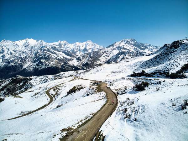
High in the Valais canton of Switzerland, Col du Sanetsch should be on anyone’s list of the toughest, most beautiful climbs in the Alps.
One weakness of the biggest/best Alpine cycling climbs? Sometimes the lower slopes are just “ok.” But the first seven kms of Col du Sanetsch are through rolling hills covered in vineyards.
These early kilometres have a touch of traffic due to a couple of perched villages, but it’s a wide, well-surfaced road. Above these villages, things get much quieter.
There are some fabulous hairpins. There are three tunnels, one of them almost a kilometre long. But this is Switzerland … it’s nicely lit.
It’s 26 kilometres and almost 1800 metres of ascent to Col du Sanetsch (or Sanetschpass). But things get even better over the top. The road descends for a couple of kilometres as Lac de Sénin (or Lac de Sanetch) comes into view. The route then rides beside the lake.
in summer, at the top is a tiny cable car that descends over the top down to Gsteig. They will take your bike. From here, one can make a gigantic route by climbing the easy but lovely Col du Pillon then descending to Aigle either directly or via Col de la Croix and riding back to the base of Sanetsch (it’s a long way) in the valley floor.
www.cycling-challenge.com/alpe-dhuez-oulles-and-col-dornon/
Oulles is the commune with the lowest population (12!) in the Isère Department. 8 kilometres cut into the edge of a steep gorge up to a little perched village. It’s a well surfaced road, with hairpins galore. And quiet: I saw no cars on the ascent or the descent. It’s quite steep.
www.cycling-challenge.com/col-du-solude/
Bring lights for tunnels on balcony road
A superb, near deserted, road with unbelievable views throughout. If you don't mind a few tunnels, this is a truly memorable loop. Remember only paved to the highest villages on each side.
some steep downhills, probably hike-a-bike
At Lac du Chambon, we turned up towards Besse, briefly following the climb to Col de Sarenne. The road remains paved until a few kms past Besse and then becomes a good quality gravel road. After Besse, we leave civilization – and keep heading up into the mountains – the fun really starts here. At 1900 metres we passed Col Nazie – but the road just kept going up. Finally we crossed over the Col Saint Georges (2245m) into a “secret” plateau: Plateau d’Emparis.”
Our next goal was Col du Souchet – this required a little detour onto hiking trails due to a misplaced ranch with unfriendly “do not enter” signs. Boo.
The Col is an amazing place. The glacier-filled peaks of La Meije dominate (these are the same mountains one sees lower down from Col du Lautaret). Sadly for our photos, the clouds had rolled in.
The 6 km descent down to Le Chazelet is not easy – it’s more a steep hiking trail than a road. Talented cyclists can ride most of it, but I had to push the bike for much of it. But again, a beautiful place.


Made in the Cotswolds. Published by Éditions Système D Ltd.
Log in with your cycle.travel account:
| Password |
Or simply use your account on: