

Hi, it would be nice to have the possibility to draw a track in a pathless area. This would be helpful in areas that are not fully covered in OSM (like the Bavarian Forest). Example:
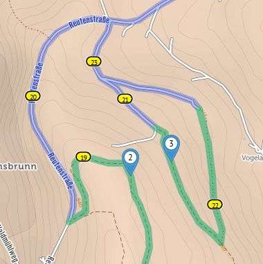
There is indeed a small path between the via-points 2 and 3 but I have found no solution in cycle.travel to draw my track directly between these two waypoints (as the path is missing in OSM). So instead of 200 m pushing I got a 2 km detour. (I will look for someone who can insert the path to OSM, but unfortunately it is not the only example.)
Best regards, Holger


Comments
Understood! It's something I'd like to do, probably by adding an option to say 'Go directly to next routing point'. But it's not trivial – it'll probably require a few changes to OSRM (the underlying routing engine) and that's never a walk in the park. Looking into it and hope to be able to implement this at some point.
Hello Richard,
thank you very much for your answer. I'm looking forward to the new feature.
By the way thank you very much for your work. The more I use cycle.travel the more I like it.
Best regards, Holger